Explorer I
Yes and yes!Or will you have the ability to create your own route down various roads/trails? And, if it's able to do the latter, will the selected route "snap to the road"?
Explorer I
Yes and yes!Or will you have the ability to create your own route down various roads/trails? And, if it's able to do the latter, will the selected route "snap to the road"?

Benefactor
0000
It’s not Google or Apple. Yes to both of your questions.@Michael Is the routing feature going to be Google/Apple maps based? Or will you have the ability to create your own route down various roads/trails? And, if it's able to do the latter, will the selected route "snap to the road"?
Thx
Trail Mechanic III
29878
@Michael - Looks awesome!It’s not Google or Apple. Yes to both of your questions.
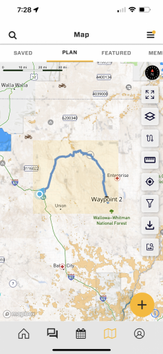
Here’s a run through I recorded Saturday while we were on the topic in another thread:

Trail Blazer III
20527
Great video! will there be capablity to switch route color as you move to a different type of routing, or just anytime you want to differentiate between sections? without stopping the route and creating a new one? I do this often in my routes and tracks and use standard colors to indicate paved, FS, two track etc.It’s not Google or Apple. Yes to both of your questions.
Here’s a run through I recorded Saturday while we were on the topic in another thread:

Advocate III
20990
Eventually… first app. Then later web page@Michael - Looks awesome!
Question, Will the route planning be available on the website as well? Us older guys can use the pixel real estate :)
-Dan
Advocate III
20990
Benefactor
0000
No, but we know that is a need. We will be doing that. First priority was making it mobile.@Michael - Looks awesome!
Question, Will the route planning be available on the website as well? Us older guys can use the pixel real estate :)
-Dan
Benefactor
0000
I'd like to learn more about this - currently it colors the whole track. Also, when you export your route as a GPX, you can import it as a Offroad Trailhead to share publicly (Routes are private for now), but then the GPX will honor our color by difficulty rules so people can quickly see the difficulty of the trail by its color.Great video! will there be capablity to switch route color as you move to a different type of routing, or just anytime you want to differentiate between sections? without stopping the route and creating a new one? I do this often in my routes and tracks and use standard colors to indicate paved, FS, two track etc.
Explorer I
Appreciate route coloring but also have a request after thinking about @OTH Overland's use case.Suggestions welcome!
Benefactor
0000
This is the communities software so I will always remain open! On last note - totally - need to have hex value entry. and "remember" recent colors used. This is in the backlog.Appreciate route coloring but also have a request after thinking about @OTH Overland's use case.
One example of how I use coloring is to make the main track one color and potential bypasses another color. This allows me to stay on track (pun intended) but also keeps me aware of what bypasses are nearby and where they end up. Its all about situational awareness with just a quick glance at the map for me. If I were to adopt @OTH Overland's methodology of coloring different types of roads with different colors (I like it!) then I _think_ that would introduce a lot of color confusion for me. Have you considered dashed lines as well as the current solid line for a route? For instance I could totally see making bypasses dashed thus reserving colors for a different use (road types).
Also, because there is always an also ;) For the route creation tool you have a color picker. Have you considered a palette of common colors or fields to enter RGB, etc., values to allow users to always get the same color? I dislike color pickers as the only way to pick a color because I am never able to get the same color between uses and would really appreciate the ability to have a standard set of colors. I do like the color picker as I see the flexibility that it offers but also like standard colors. Call me Mr OCD ;)
Thanks! For remaining open to our nits and responding!
Trail Mechanic III
29878
+1 on the solid primary, dashed secondary.This is the communities software so I will always remain open! On last note - totally - need to have hex value entry. and "remember" recent colors used. This is in the backlog.
Dashed vs solid - one thing we might do is have a setting during route creation - in addition to choosing routing method, choose "Primary", "Secondary" and style those differently (thinner line, 30% opacity, dashed, something).
Another consideration - remove color by difficulty all together and relegate difficulty to the summary card and detail page - they would still be searchable by difficulty type, and filterable by difficulty as they are now.

Advocate II
29953
changing the color of the line! huge! thank you Michael. still watching but had to pause just to post this haha.It’s not Google or Apple. Yes to both of your questions.
Here’s a run through I recorded Saturday while we were on the topic in another thread:
Advocate II
29953
Its important to keep the trail color by difficulty for the track, but also the ability for the trail color to be preference while navigating (perhaps color inside with trail difficulty outline [this is only during turn by turn nav style]. What I dont want to see is color spaghetti when looking around the app at others trails, but if I click on one and use it to navigate it should fill color to my preference while navigating it. I love the idea as well of having the color change from pavement to off road.I'd like to learn more about this - currently it colors the whole track. Also, when you export your route as a GPX, you can import it as a Offroad Trailhead to share publicly (Routes are private for now), but then the GPX will honor our color by difficulty rules so people can quickly see the difficulty of the trail by its color.
I'd like to accommodate the best thing for the community without being totally confusing. Suggestions welcome!
Benefactor
0000
Difficulty in the Details is already a thing - so the info is avail.+1 on the solid primary, dashed secondary.
Also (there it is @Ubiety) maybe just float a "4/10" like a trail name for the difficulty? Otherwise, the summary card option is probably mor fun... Surprise! it's a 9!
Benefactor
0000
This is done. It’s a one time pop up.Please make it some type of off-road truck or jeep. May I recommend a pop up window when you select that mode to remind anyone using it that it may route to bike paths etc (trails that shouldn’t be driven on) and require the user to press accept or go back to car/ paved road modeVery exciting! We are just about to release MVP of route planning in the OB1 app and it would be great to get a little feedback from you on one of the more challenging route planning options. The challenge is making it clear to you what is happening. We have four Route planning modes between waypoints and you can change modes any time. The modes are:
Car: This will route along maintained roads. Think Waze, Google, Apple maps.
Bike: This includes unmaintained roads like Forest Service roads and other paths - with a couple complications: 1. It will include paths you really should not be driving on 2. It optimizes routes in cities along roads with bike paths.
Walking: Hiking and walking paths.
Bird: As the bird flies. This is a straight line between waypoints.
View attachment 235560
The complication is bike paths. If you start routing with OB1 and start plotting points on a forest service road in "Car" mode, it will not route along the road. Switching to Bike mode, it will route. If we make that icon an offroad truck, it will route correctly, but also have the anomalies mentioned above. I thing the offroad truck will be most clear to the community and result in more happiness with OB1 users, but have the tradeoffs. The question is, leave it a bike or make it an offroad truck?
Thank you!

Pioneer II
24720
Sorry about that, it didn’t show any of the previous responses until after I posted a comment.This is done. It’s a one time pop up.Please make it some type of off-road truck or jeep. May I recommend a pop up window when you select that mode to remind anyone using it that it may route to bike paths etc (trails that shouldn’t be driven on) and require the user to press accept or go back to car/ paved road modeVery exciting! We are just about to release MVP of route planning in the OB1 app and it would be great to get a little feedback from you on one of the more challenging route planning options. The challenge is making it clear to you what is happening. We have four Route planning modes between waypoints and you can change modes any time. The modes are:
Car: This will route along maintained roads. Think Waze, Google, Apple maps.
Bike: This includes unmaintained roads like Forest Service roads and other paths - with a couple complications: 1. It will include paths you really should not be driving on 2. It optimizes routes in cities along roads with bike paths.
Walking: Hiking and walking paths.
Bird: As the bird flies. This is a straight line between waypoints.
View attachment 235560
The complication is bike paths. If you start routing with OB1 and start plotting points on a forest service road in "Car" mode, it will not route along the road. Switching to Bike mode, it will route. If we make that icon an offroad truck, it will route correctly, but also have the anomalies mentioned above. I thing the offroad truck will be most clear to the community and result in more happiness with OB1 users, but have the tradeoffs. The question is, leave it a bike or make it an offroad truck?
Thank you!
Benefactor
0000
Oh no problem at all!Sorry about that, it didn’t show any of the previous responses until after I posted a comment.This is done. It’s a one time pop up.Please make it some type of off-road truck or jeep. May I recommend a pop up window when you select that mode to remind anyone using it that it may route to bike paths etc (trails that shouldn’t be driven on) and require the user to press accept or go back to car/ paved road modeVery exciting! We are just about to release MVP of route planning in the OB1 app and it would be great to get a little feedback from you on one of the more challenging route planning options. The challenge is making it clear to you what is happening. We have four Route planning modes between waypoints and you can change modes any time. The modes are:
Car: This will route along maintained roads. Think Waze, Google, Apple maps.
Bike: This includes unmaintained roads like Forest Service roads and other paths - with a couple complications: 1. It will include paths you really should not be driving on 2. It optimizes routes in cities along roads with bike paths.
Walking: Hiking and walking paths.
Bird: As the bird flies. This is a straight line between waypoints.
View attachment 235560
The complication is bike paths. If you start routing with OB1 and start plotting points on a forest service road in "Car" mode, it will not route along the road. Switching to Bike mode, it will route. If we make that icon an offroad truck, it will route correctly, but also have the anomalies mentioned above. I thing the offroad truck will be most clear to the community and result in more happiness with OB1 users, but have the tradeoffs. The question is, leave it a bike or make it an offroad truck?
Thank you!
Benefactor
0000
This is what the pop up looks like when folks first use the off-road routing mode:Sorry about that, it didn’t show any of the previous responses until after I posted a comment.This is done. It’s a one time pop up.Please make it some type of off-road truck or jeep. May I recommend a pop up window when you select that mode to remind anyone using it that it may route to bike paths etc (trails that shouldn’t be driven on) and require the user to press accept or go back to car/ paved road modeVery exciting! We are just about to release MVP of route planning in the OB1 app and it would be great to get a little feedback from you on one of the more challenging route planning options. The challenge is making it clear to you what is happening. We have four Route planning modes between waypoints and you can change modes any time. The modes are:
Car: This will route along maintained roads. Think Waze, Google, Apple maps.
Bike: This includes unmaintained roads like Forest Service roads and other paths - with a couple complications: 1. It will include paths you really should not be driving on 2. It optimizes routes in cities along roads with bike paths.
Walking: Hiking and walking paths.
Bird: As the bird flies. This is a straight line between waypoints.
View attachment 235560
The complication is bike paths. If you start routing with OB1 and start plotting points on a forest service road in "Car" mode, it will not route along the road. Switching to Bike mode, it will route. If we make that icon an offroad truck, it will route correctly, but also have the anomalies mentioned above. I thing the offroad truck will be most clear to the community and result in more happiness with OB1 users, but have the tradeoffs. The question is, leave it a bike or make it an offroad truck?
Thank you!

Advocate II
29953
Theres no real way around this is there ("this" being single track or bike only use). Until enough members fill out the OB1 map with tracks that have the info. It would be nice to have either a bike icon for bike only tracks, or have the ability to filter out bike only tracks. But totally get thats complicated and not priority for quite some time as theres a lot of things on the list lol.This is what the pop up looks like when folks first use the off-road routing mode:

Protector III
20111
I think it's good! Such a similar text popup could also be used for the dispersed camping topic we recently exchanged on.This is what the pop up looks like when folks first use the off-road routing mode: