Trans America Trail Trip 2018

  • HTML tutorial

WIGGLE

Rank V
Launch Member

Enthusiast II

1,428
Carmel, IN
First Name
Patrick
Last Name
Hettle
Member #

10385

I can’t believe it’s finally here. Months of preparation and dreaming and it’s finally here. Tomorrow morning we set out to start the Trans America Trail. We are doing the “official” TAT using Sam Correro’s maps and will be hitting the NEW sections so we will be starting from the NEW trail head in Marlinton West Virginia. There’s not much if anything on the new sections that now precede the trailhead in Andrews, NC, at least that I’ve been able to find so I think we will be some of the first to ride this section. Can’t lie, that’s nerve wracking as I don’t know what to expect. The weather isn’t exactly what I’d hoped for but hey, it’s adventure.

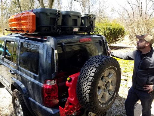
Our rig is a 2006 Jeep Commander Limited with QDII and a Hemi. Lifted about 2 ½” and running 32” KO2’s which raise it about another 1 ½”.

We’ll be camping as much as possible the whole route and I’ll be trying to snap as many pictures as possible along the way and update this thread as often as possible as we go. We’ll also be posting on our Instagram as we go along so please check that out as well @overland.in

Tomorrow morning we’ll begin our drive from Carmel, IN down to Marlinton to start the trail fresh on Saturday morning. The following Saturday we’ll have to head back home so we’ll see how far we get.

Pretty excited, this should be fun!

Stay tuned, many many pictures to come!
 

TonyC

Rank IV
Launch Member

Enthusiast III

1,146
Rochester, NY
First Name
Tony
Last Name
Correa
Member #

7661

Ham/GMRS Callsign
KD2PTJ
Service Branch
USAF, National Guard
I can’t believe it’s finally here. Months of preparation and dreaming and it’s finally here. Tomorrow morning we set out to start the Trans America Trail. We are doing the “official” TAT using Sam Correro’s maps and will be hitting the NEW sections so we will be starting from the NEW trail head in Marlinton West Virginia. There’s not much if anything on the new sections that now precede the trailhead in Andrews, NC, at least that I’ve been able to find so I think we will be some of the first to ride this section. Can’t lie, that’s nerve wracking as I don’t know what to expect. The weather isn’t exactly what I’d hoped for but hey, it’s adventure.

Our rig is a 2006 Jeep Commander Limited with QDII and a Hemi. Lifted about 2 ½” and running 32” KO2’s which raise it about another 1 ½”.

We’ll be camping as much as possible the whole route and I’ll be trying to snap as many pictures as possible along the way and update this thread as often as possible as we go. We’ll also be posting on our Instagram as we go along so please check that out as well @overland.in

Tomorrow morning we’ll begin our drive from Carmel, IN down to Marlinton to start the trail fresh on Saturday morning. The following Saturday we’ll have to head back home so we’ll see how far we get.

Pretty excited, this should be fun!

Stay tuned, many many pictures to come!
Safe journey Wiggle!
 
  • Like
Reactions: skip371

WIGGLE

Rank V
Launch Member

Enthusiast II

1,428
Carmel, IN
First Name
Patrick
Last Name
Hettle
Member #

10385

I did the NC and part of TN a couple of weekends ago. Excited for you! Have a great time and be safe!
Oh awesome! How were the NC sections? Was wondering about the hurricane Creek road part. Sam has it marked on the GPS and maps but also with a bypass. Ha ha the way point in the GPS from him is actually labeled "6 miles of hell". Is it really that bad?

Sent from my SM-G935V using OB Talk mobile app
 

killallninjas

Rank V
Launch Member

Enthusiast III

1,721
Atlanta, GA
Member #

7027

Oh awesome! How were the NC sections? Was wondering about the hurricane Creek road part. Sam has it marked on the GPS and maps but also with a bypass. Ha ha the way point in the GPS from him is actually labeled "6 miles of hell". Is it really that bad?

Sent from my SM-G935V using OB Talk mobile app
The sun was setting and it started raining when I hit Hurricane Creek road, and I was alone. I went a few minutes in. There were already mud holes and the terrain was definitely rougher than the rest of the route. I had never run that road before, so I wasn't familiar with it. I opted to turn around and take the bypass.
 

WIGGLE

Rank V
Launch Member

Enthusiast II

1,428
Carmel, IN
First Name
Patrick
Last Name
Hettle
Member #

10385

Hi guys, so sorry for the extreme delay in updating this. I’ve been bouncing around for work since we got back. Long story short, things did not go as planned, but we still had a GREAT time. We wound up with a blown radiator, cracked windshield and we lost three days in Virginia waiting on repairs. We wound up finishing the entire Virginia section for this trip but didn’t make it to the North Carolina section yet. Still hoping to get back down soon and pick up where we left off. I’ll be uploading the details here shortly.
 

Johnnyswell

Rank 0

Traveler I

Hi guys, so sorry for the extreme delay in updating this. I’ve been bouncing around for work since we got back. Long story short, things did not go as planned, but we still had a GREAT time. We wound up with a blown radiator, cracked windshield and we lost three days in Virginia waiting on repairs. We wound up finishing the entire Virginia section for this trip but didn’t make it to the North Carolina section yet. Still hoping to get back down soon and pick up where we left off. I’ll be uploading the details here shortly.
Hey man, what's your GPS setup looking like with Sam's maps and GPS files. I want to get his maps buy not sure what hardware and apps to use. I was thinking about grabbing an iPad mini for it. What do you think?
 

WIGGLE

Rank V
Launch Member

Enthusiast II

1,428
Carmel, IN
First Name
Patrick
Last Name
Hettle
Member #

10385

Hey man, what's your GPS setup looking like with Sam's maps and GPS files. I want to get his maps buy not sure what hardware and apps to use. I was thinking about grabbing an iPad mini for it. What do you think?
For GPS I used a Samsung Galaxy Tab A running Gaia GPS with Sam’s tracks loaded. That was my primary source of navigation, but I also had a Garmin inReach Explorer + with Sam’s tracks loaded as well but that was primarily used for tracking and staying in touch with friends and family. Something like an iPad mini would work just perfect too. Side note, there is almost NO signal for Verizon along the Virginia section of trail, but my girlfriends Sprint phone worked almost the whole time. Sam’s tracks are spot on through this section of the trail and actually very easy to follow. The tracks import just fine right in to Gaia and I didn’t have to do any work or editing on them at all. I also imported them into the inReach software and they worked great there too.
 

luchaDor

Rank VI
Launch Member
Member

Pioneer II

3,774
Urbandale, IA 50323, USA
First Name
Doran
Last Name
Else
Member #

2879

Bummer on the radiator. My Commander is an '08 and I'm planning on doing a complete cooling system swap this Fall. Radiator, hoses, water pump, thermostat, etc...the plastics just don't last forever. I wish there was an all aluminum replacement.
 

WIGGLE

Rank V
Launch Member

Enthusiast II

1,428
Carmel, IN
First Name
Patrick
Last Name
Hettle
Member #

10385

Things did not go as planned…… but more on that later!


TAT Day 0 – The trip to the trailhead: Carmel, IN to Marlinton, WV

We left Home around 2:00 PM on Friday to head down to Marlinton, no real rush as we were not planning to hit the trail that night and instead planned on getting a good night sleep, doing some final repacking of the Commander and getting our last shower and big breakfast for a while.

Here's me wondering if I packed the keys in one of those bins... 20180420_124945.jpg
About 45 minutes into our trip on I70, after hitting a bump we started to get pelted by what I’m assuming were rocks from a truck in front of us, several of them hit us and we received a pretty deep dime sized chip/crack in our windshield in addition to several other small chips. This sucked. Not even on the trail yet and we managed to hurt the Jeep…

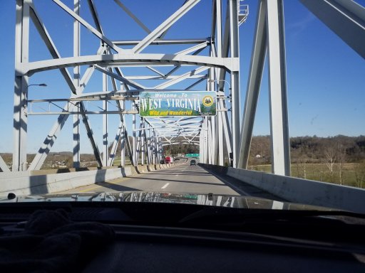
Welcome to West Virginia!!!


20180420_182322.jpg
Fast forward several hours… We arrived at the Marlinton Motor Inn which is located right at the start of the new Virginia sections of the trail. This is awesomely convenient. This was actually a pretty nice old motel, totally old school, wood paneling on EVERYTHING! Good place, friendly service and a really good restaurant. We unpacked our bags and settled in for a good night sleep.
 

WIGGLE

Rank V
Launch Member

Enthusiast II

1,428
Carmel, IN
First Name
Patrick
Last Name
Hettle
Member #

10385

Bummer on the radiator. My Commander is an '08 and I'm planning on doing a complete cooling system swap this Fall. Radiator, hoses, water pump, thermostat, etc...the plastics just don't last forever. I wish there was an all aluminum replacement.
Yeah it was tough. I know it's "all part of the adventure" but... that's still losing three days of your trip and that's a bummer.
 
  • Like
Reactions: luchaDor