Traveler III
Hey all,
I came upon a minor mystery while doing map recces of the area I often go exploring near my home. I found a location marked on Google maps as "Boundary." At first I didn't even realize it was a place, because it looked like the word "boundary" labeling the Canada/US border. Only once I realized I could click on it did I realize it was actually a name of a town, a ghost town, more specifically.
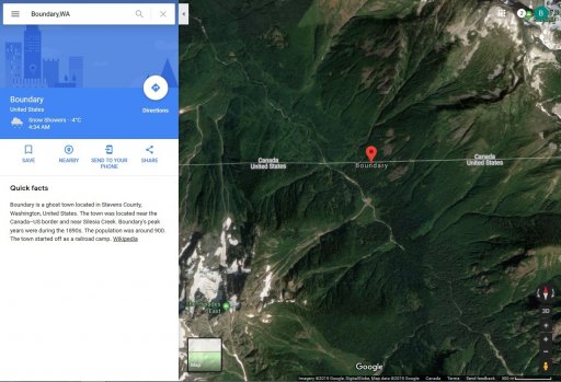
A little more research led me to the conclusion that its location is grossly incorrect on Google maps. The wikipedia article that google maps links to suggests that the town was located on the banks of Silesia creek, which seems to be the US name for Slesse Creek north of the Border near Chilliwack, however, all the scant online sources I could find including Wikipedia agree that Boundary, WA was located in Stevens County, far to the east of Chilliwack.
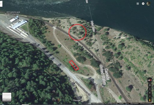
As you can see by the image attached, the satellite imagery shows absolutely no trace of any settlement in this area, but more tellingly, the terrain absolutely does not seem amenable to building a settlement. None of the other details match either, like the mention of "New Boundary" being built to the south later on.
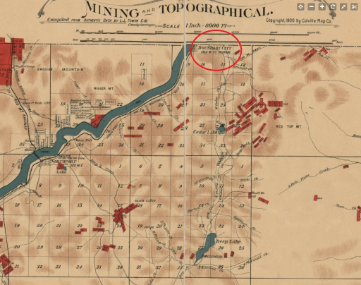
A website about ghost towns of Stevens County mentions that Boundary was between "The Little Flat" and the Columbia river. So far I'm unable to locate the former, and thus I have yet to find anything on the satellite map that looks to me like the ruins of Boundary.
I thought I'd hop on OB and put out the call - has anyone from the PNW ever visited Boundary? I know we have a lot of ghost town enthusiasts and explorers on here, so I figured I'd ask you guys. If you've been there, please post your experiences, pics, whatever. Perhaps we can get the location corrected on Google Maps somehow too!
I came upon a minor mystery while doing map recces of the area I often go exploring near my home. I found a location marked on Google maps as "Boundary." At first I didn't even realize it was a place, because it looked like the word "boundary" labeling the Canada/US border. Only once I realized I could click on it did I realize it was actually a name of a town, a ghost town, more specifically.

A little more research led me to the conclusion that its location is grossly incorrect on Google maps. The wikipedia article that google maps links to suggests that the town was located on the banks of Silesia creek, which seems to be the US name for Slesse Creek north of the Border near Chilliwack, however, all the scant online sources I could find including Wikipedia agree that Boundary, WA was located in Stevens County, far to the east of Chilliwack.
As you can see by the image attached, the satellite imagery shows absolutely no trace of any settlement in this area, but more tellingly, the terrain absolutely does not seem amenable to building a settlement. None of the other details match either, like the mention of "New Boundary" being built to the south later on.
A website about ghost towns of Stevens County mentions that Boundary was between "The Little Flat" and the Columbia river. So far I'm unable to locate the former, and thus I have yet to find anything on the satellite map that looks to me like the ruins of Boundary.
I thought I'd hop on OB and put out the call - has anyone from the PNW ever visited Boundary? I know we have a lot of ghost town enthusiasts and explorers on here, so I figured I'd ask you guys. If you've been there, please post your experiences, pics, whatever. Perhaps we can get the location corrected on Google Maps somehow too!
Last edited:


