Ask About Gaia GPS!

  • HTML tutorial

1Louder

Rank VI
Launch Member

Member II

4,187
AZ
First Name
Chris
Last Name
K
Member #

1437

Ham/GMRS Callsign
K1LDR
Thank you for your answer!

So, the guide me feature is useless for waypoints in the desert? This would seem obvious as I can’t image there are turn by turn directions.
It's not useless. It is just specific information your waypoint in a straight line is here, this distance and this heading. If you are on a really curvy trail then that information won't be that accurate. Straight line, as the crow flies, might be 2 miles and the trail 10. Just create a waypoint near you and try out the feature.

Would you say the Guide Me feature is mainly for city driving?
No again it is only straight line and has nothing to do with roads or trails. However, you can link out to Apple Maps or Google Maps from within the app to attempt to get driving directions. Let's say your starting point waypoint is 200 miles a way. For the most part Apple and Google can tell you how to get there. Arrive and then start using Gaia.
 

HappyOurOverlanding

Rank VI
Launch Member

Member III

3,402
Verdi Nevada
Member #

9206

Ham/GMRS Callsign
KI7RAM
So I downloaded Gaia on my new android and tested it out today. It tracked great on the normal curvy roads in Reno. I like the pause and restart track feature since I made several stops along the way. Tomorrow I will test it on the trail.

Before I invest in a tablet, I am trying to learn the Gaia maps and functions on the website. I must say....I have never used a GPS/cell Map system before so it is a slow learning curve. LOL.... but I'll get there.

Thanks for starting and monitoring this thread. I'm sure I'll have some questions on filing system and import from other maps (which I did from a Garmin track I saved). The Garmin import definitely seemed to track strange compared to the test track I did today.

Anyway....thanks again @1Louder
 
  • Like
Reactions: Road and 1Louder

Kent R

OB Executive Director
Staff member
Mod Team
Moderator
Member

Pathfinder III

5,200
El Dorado, Ca
First Name
Kent
Last Name
Reynolds
Member #

1632

Ham/GMRS Callsign
K6KNT
Service Branch
Retired Firefighter
So I downloaded Gaia on my new android and tested it out today. It tracked great on the normal curvy roads in Reno. I like the pause and restart track feature since I made several stops along the way. Tomorrow I will test it on the trail.

Before I invest in a tablet, I am trying to learn the Gaia maps and functions on the website. I must say....I have never used a GPS/cell Map system before so it is a slow learning curve. LOL.... but I'll get there.

Thanks for starting and monitoring this thread. I'm sure I'll have some questions on filing system and import from other maps (which I did from a Garmin track I saved). The Garmin import definitely seemed to track strange compared to the test track I did today.

Anyway....thanks again @1Louder
If you want you can take my iPad in your rig today and check out how it works on the trail. Ill bring an extra power cord.
 

stevenboise

Rank IV
Launch Member

Enthusiast III

1,221
Boise, ID, USA
Member #

4146

I bought Gaia Premium a few months ago and getting ready for a two week trip in May. I tried to upload maps for offline use last night and after doing a lot of them, I realized many never uploaded. I couldn’t figure out why as many did upload just fine and I was doing the same thing for each map.

After some frustrating time, I noticed an error message in my maps that wouldn’t upload. The error says there is a 160,000 tile limit to uploads.

I bought a 512GB iPad so I wouldn’t run out of space when I uploaded my maps. I assumed (I never saw any literature to counter this) I could upload as many maps as my device could hold. But now, that seems incorrect.

Can anyone confirm there is a max upload capacity from Gaia regardless of your device’s capacity?
 

James Deaton

Rank V

Pathfinder I

You are trying to highlight too big of a section. Each section has tiles in it. Highlight a smaller section, under 10,000 tiles. Once the tile count turns red that you know you have too many tiles highlighted in the section.
 

Dcwn.45

Rank IV
Member

Member I

1,338
Minnesota
First Name
David
Last Name
Nyman
Member #

30299

Ham/GMRS Callsign
KF0GNE
I bought Gaia for my Samsung tab3 and I don't have enough memory to install the maps, I can get a larger chip, how much memory do I need to load the us, Canada , and Mexico?
 

stevenboise

Rank IV
Launch Member

Enthusiast III

1,221
Boise, ID, USA
Member #

4146

You are trying to highlight too big of a section. Each section has tiles in it. Highlight a smaller section, under 10,000 tiles. Once the tile count turns red that you know you have too many tiles highlighted in the section.
I did make this mistake initially. Each map must be under 10k tiles. So I stayed under this limit for each individual map.

After uploading a number of maps, they stopped uploading. I didn’t catch this right away. Couldn’t figure it out till I found an error message in one of the maps that stopped uploading.

It said max tile limit 160,000. That seems to me to be a maximum tile download for my entire project, not just a specific map. That’s the number (question I have) I’m asking about.....is there some “hidden” max one can download for offline use?
 

stevenboise

Rank IV
Launch Member

Enthusiast III

1,221
Boise, ID, USA
Member #

4146

Make sure you change the resolution slider to high-resolution if you plan to read them off-line and want them to be legible
Yes, I made my resolution level 17 for that reason. But it does make the maps larger, both in tile size and memory size. But, I’m okay with that as I have the space....so I thought.
 

stevenboise

Rank IV
Launch Member

Enthusiast III

1,221
Boise, ID, USA
Member #

4146

I bought Gaia for my Samsung tab3 and I don't have enough memory to install the maps, I can get a larger chip, how much memory do I need to load the us, Canada , and Mexico?
There is a limit to the size of each individual map. Depending on your resolution. I’m still working on my project so I tested your question out. In order to download the entire US, you would have to drop to the lowest possible resolution (level 9) to collect the entire country. I doubt you’d get a very good read on that data, but I haven’t tried. At level 9, it used up 5,282 tiles. When I go to level 10, I jump up to 20k tiles. Level 9 is only about 167MB....so you can see how lously that resolution will be.

Same goes with Canada and Mexico.

Also, if my problem I’m outlining in my earlier post is correct, there is a total limit to the number of tiles one can upload (160,000). I have this question in to Gaia to confirm still. You might be able to do this by staying under level 12 zoom (I just played around a bit with this) but that would probably be pretty close. This is still just 2.58GB.

I can’t image you would have any sort of readablity at these zoom levels for those size maps. You will have to upload maps as you go about your trip and keep the zoom high, around 15 - 17 (17 is the highest).
 

stevenboise

Rank IV
Launch Member

Enthusiast III

1,221
Boise, ID, USA
Member #

4146

You are trying to highlight too big of a section. Each section has tiles in it. Highlight a smaller section, under 10,000 tiles. Once the tile count turns red that you know you have too many tiles highlighted in the section.
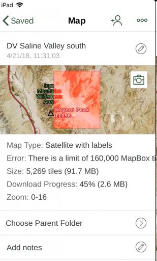
Here is a screen shot of what I’m referring to. As you can see, the tile size is just 5,269, I’m using just one map (Satellite with Labels) but it has stopped downloading at 45%. In order to get this error, I had to upload a bunch of maps to exceed the 160,000.

See that error? “There is a limt of 160,000 MapBox ti.....” the text goes off the screen (another glitch in the Gaia software) so I can’t read the entire error message.
 

Attachments

1Louder

Rank VI
Launch Member

Member II

4,187
AZ
First Name
Chris
Last Name
K
Member #

1437

Ham/GMRS Callsign
K1LDR
Splitting hairs but you are talking about downloading maps to your device and not uploading. I say this because if you contact support you want to use the proper terminology.

Some map layers have a 10k limit as someone else mentioned. (MapBox for example) There are some discussions on the Gaia community forum. I don’t remember the specific map layers. For a good overall view of a place the GAIA Topo map layer will require the least amount of space. There are more detailed maps like the USFS, where available, but you will need to take the time to play with the different map layers.

For those trying to download all of North America that really isn’t what Gaia is designed to do. I would use an app like Pocket Earth for that or Maps.me. They provide a good overview but will not have all of the off-road stuff like smaller forest roads and marked Jeep trails.

There is an article on my site which discusses how to add Google maps to your personal Gaia account. You might give that a read as well. 4XOA.com

The tile download limits have to do with server overhead, and licensing costs I believe but you could get a more detailed response from
Gaia support.

Also as mentioned if you don’t need a zoom level down to 50-100ft you can greatly reduce the download sizes.

Reference:
https://help.gaiagps.com/hc/en-us/articles/360000915488-Individual-Offline-Map-Tile-Limits

https://help.gaiagps.com/hc/en-us/community/posts/115007587827-Download-Tile-Limit
 

stevenboise

Rank IV
Launch Member

Enthusiast III

1,221
Boise, ID, USA
Member #

4146

Splitting hairs but you are talking about downloading maps to your device and not uploading. I say this because if you contact support you want to use the proper terminology.

Some map layers have a 10k limit as someone else mentioned. (MapBox for example) There are some discussions on the Gaia community forum. I don’t remember the specific map layers. For a good overall view of a place the GAIA Topo map layer will require the least amount of space. There are more detailed maps like the USFS, where available, but you will need to take the time to play with the different map layers.

There is an article on my site which discusses how to add Google maps to your personal Gaia account. You might give that a read as well. 4XOA.com

The tile download limits have to do with server overhead, and licensing costs I believe but you could get a more detailed response from
Gaia support.

Reference:
https://help.gaiagps.com/hc/en-us/articles/360000915488-Individual-Offline-Map-Tile-Limits

https://help.gaiagps.com/hc/en-us/community/posts/115007587827-Download-Tile-Limit
Holy cow, that's the information I needed!

I don't mind the splitting hairs.....I need to use the right terms. I totally understand that...thanks for pointing that out.

Man alive, they need to include those threads in the section on "How to download for offline use." That would have saved me endless hours of frustrations.

Thanks again!
 
  • Like
Reactions: 1Louder

1Louder

Rank VI
Launch Member

Member II

4,187
AZ
First Name
Chris
Last Name
K
Member #

1437

Ham/GMRS Callsign
K1LDR
Holy cow, that's the information I needed!

I don't mind the splitting hairs.....I need to use the right terms. I totally understand that...thanks for pointing that out.

Man alive, they need to include those threads in the section on "How to download for offline use." That would have saved me endless hours of frustrations.

Thanks again!
If you think that will help others pass that information on to the Gaia support team.
 

stevenboise

Rank IV
Launch Member

Enthusiast III

1,221
Boise, ID, USA
Member #

4146

If you think that will help others pass that information on to the Gaia support team.
I posted those two threads in the comment section in the "How to download maps for offline use" along with some suggestions as to what to add to those instructions. That's where I started last night to figure out how to do this. The instructions were good, just not complete.
 
  • Like
Reactions: 1Louder

jeep670

Rank IV

Pathfinder I

My problem with Gaia is that the track line is just a thin line of which thickness cannot be changed. Does not matter how much I zoom in the track is barely visible regardless of the colour of the line. This is a problem specific to the high resolution screens today's devices come with. Same behavior on my Android phones and my iPads due to high rez screens.
I have 3 levels of track thickness in BackCountry Navigator and I can actually see where I'm supposed to go when I pick a thicker line.
Is there such a setting in Gaia?
 
  • Like
Reactions: danl

1Louder

Rank VI
Launch Member

Member II

4,187
AZ
First Name
Chris
Last Name
K
Member #

1437

Ham/GMRS Callsign
K1LDR
My problem with Gaia is that the track line is just a thin line of which thickness cannot be changed. Does not matter how much I zoom in the track is barely visible regardless of the colour of the line. This is a problem specific to the high resolution screens today's devices come with. Same behavior on my Android phones and my iPads due to high rez screens.
I have 3 levels of track thickness in BackCountry Navigator and I can actually see where I'm supposed to go when I pick a thicker line.
Is there such a setting in Gaia?
There is not a setting for this. I think it has been suggested in the community forums. If it has you can vote on it. If not post up the suggestion there and encourage people to vote for your idea.