The OFFICIAL Trans NJ Trail Thread

  • HTML tutorial

Xplorr313

Rank V
Founder 500
Launch Member

Enthusiast III

2,421
Burlington, NJ
First Name
Leon
Last Name
Jones
Member #

0313

Ham/GMRS Callsign
WQYY816
Hey guys, and gals, I decided to create an “official” Trans New Jersey Trail thread. This is where you can find the “official” route and any route info you need to know. Also, this thread will be good for those to post info about the route; like road closures, detours, dangers, trees down, and anything else that may restrict access to the trail.

If anyone wants a copy of the route, it is FREE and available at the bottom of this post. I will accept donations if you feel inclined to donate to the beer fund. The donations can be sent to xplorr313@gmail.com. The donations are not required though!

Previously I charged for the route due to keeping the route out of the hands of those who were only looking to “off-road” or “wheel” illegally on state land. I received a lot of backlash from the off-roading / Overlanding community for charging for the route. I put over 2 years of my life into making this route, please stay on the path and DO NOT “off-road” or “wheel” off of the path. This could cause closures and could also land you in major trouble with the state, for example: a hefty fine or even vehicle impoundment. I’ve seen and heard about it happening. Do not think it won’t happen to you. The state does have trail cameras along some of the more “prone to off-roading” spots. You will get caught.

The route is current and up to date as of 1-16-2020. The most recent revision of the route was done on 1-16-2020. If you have any version older than 1-16-2020 please reach out to me for an updated version. I will keep this post updated with the most recent version of the route.

I HIGHLY RECOMMEND THE LEADNAV APP FOR THE BEST EXPERIENCE. LeadNav is only for iPhones and iPads. The route can be used on other devices, but the route was made with and for LeadNav.

For those of you who are just learning about the Trans New Jersey Trail, the trail is a 450+ mile route that spans from High Point, NJ to Cape May, NJ. The trail consist of asphalt, gravel, sand, dirt, and some mud. The trail is 100% legal for all street legal vehicles. This means you must be registered, insured, and compliant with all DOT regulations (headlights, taillights, seat belts, turn signals, and so on).

The TNJT can be completed in a Subaru as long as the driver is experienced. There is NOTHING complicated on this route. There ARE bypasses for those who do not have a snorkel or the ability to traverse deep mud holes. The bypasses are clearly marked as separate routes. The Zillon Bypass is recommended for those who do not wish to traverse down an extremely tight trail and do not want to risk the couple extremely sloppy mud holes along that part of the TNJT. The Zillon Bypass is 100% asphalt that bypasses the tight trail and sloppy mud holes.

The whole route CAN be done in 3 days. I completed the route in 4 days when I ran it start to end non stop in 2017. My 4th day on the trail only consisted of 50 miles and I could have just finished it on day 3.

The trail has 3 sections North, Central, and South. I consider the North section to go from High Point, NJ to Round Valley Reservoir (Spruce Run Recreation Area [campground]). The Central section to go from Round Valley Reservoir to Brendan T. Byrne State Forest (camping is available in Brendan T. Byrne State Forest). The South section to go from Brendan T. Byrne State Forest to Cape May, NJ. If you feel inclined to turn it into a 4 day trip, I recommend stopping at Belleplain State Forest for an overnight stay.

I do plan to offer 4 versions of the TNJT. A full length version, which is what I have been passing out to everyone, and the three sections. This will allow daytrippers to do the route one section at a time. I will post when the 4 versions are available. Right now just the whole route is available.

Anyone have any questions, please reach out to me by email or ask here!
 

Attachments

Last edited:

Virginia Overlander

Rank II
Launch Member

Off-Road Ranger I

301
Charles City, VA, USA
Member #

12980

Ham/GMRS Callsign
WRCJ633
Hey guys, and gals, I decided to create an “official” Trans New Jersey Trail thread. This is where you can find the “official” route and any route info you need to know. Also, this thread will be good for those to post info about the route; like road closures, detours, dangers, trees down, and anything else that may restrict access to the trail.

If anyone wants a copy of the route, it is free and available by sending me an email at xplorr313@gmail.com. I will accept donations if you feel inclined to donate to the beer fund.

Previously I charged for the route due to keeping the route out of the hands of those who were only looking to “off-road” or “wheel” illegally on state land. I received a lot of backlash from the off-roading / Overlanding community for charging for the route. I put over 2 years of my life into making this route, please stay on the path and DO NOT “off-road” or “wheel” off of the path. This could cause closures and could also land you in major trouble with the state, for example: a hefty fine or even vehicle impoundment. I’ve seen and heard about it happening. Do not think it won’t happen to you. The state does have trail cameras along some of the more “prone to off-roading” spots. You will get caught.

The route is current and up to date as of 9-12-18. The most recent revision of the route was done on 9-12-18. If you have any version older than 9-12-18 please reach out to me for an updated version. I will keep this post updated with the most recent version of the route.

I HIGHLY RECOMMEND THE LEADNAV APP FOR BEST THE BEST EXPERIENCE. LeadNav is only for iPhones and iPads. The route can be used on other devices, but the route was made with and for LeadNav.


For those of you who are just learning about the Trans New Jersey Trail, the trail is a 450+ mile route that spans from High Point, NJ to Cape May, NJ. The trail consist of asphalt, gravel, sand, dirt, and some mud. The trail is 100% legal for all street legal vehicles. This means you must be registered, insured, and compliant with all DOT regulations (headlights, taillights, seat belts, turn signals, and so on).

The TNJT can be completed in a Subaru as long as the driver is experienced. There is NOTHING complicated on this route. There ARE bypasses for those who do not have a snorkel or the ability to traverse deep mud holes. The bypasses are clearly marked as separate routes. The Zillon Bypass is recommended for those who do not wish to traverse down an extremely tight trail and do not want to risk the couple extremely sloppy mud holes along that part of the TNJT. The Zillon Bypass is 100% asphalt that bypasses the tight trail and sloppy mud holes.

The whole route CAN be done in 3 days. I completed the route in 4 days when I ran it start to end non stop in 2017. My 4th day on the trail only consisted of 50 miles and I could have just finished it on day 3.

The trail has 3 sections North, Central, and South. I consider the North section to go from High Point, NJ to Round Valley Reservoir (Spruce Run Recreation Area [campground]). The Central section to go from Round Valley Reservoir to Brendan T. Byrne State Forest (camping is available in Brendan T. Byrne State Forest). The South section to go from Brendan T. Byrne State Forest to Cape May, NJ. If you feel inclined to turn it into a 4 day trip, I recommend stopping at Belleplain State Forest for an overnight stay.

I do plan to offer 4 versions of the TNJT. A full length version, which is what I have been passing out to everyone, and the three sections. This will allow daytrippers to do the route one section at a time. I will post when the 4 versions are available. Right now just the whole route is available.

Anyone have any questions, please reach out to me by email or ask here!
Is the route a GPX file. I use Gaia for off road navigation
 

Xplorr313

Rank V
Founder 500
Launch Member

Enthusiast III

2,421
Burlington, NJ
First Name
Leon
Last Name
Jones
Member #

0313

Ham/GMRS Callsign
WQYY816
Is the route a GPX file. I use Gaia for off road navigation
Yes the route is in GPX format but due to the way LeadNav formats the route into GPX, some other apps and devices do not get the full effect that LeadNav offers. Others who have used the route and Gaia have not had an issue but LeadNav actually offers the users audioable turn by turn directions with ETA notifications and distance notifications before the next turn. Plus some of the waypoints do not show up on other devices. This is why I always recommend LeadNav for those who are looking to run any of my routes.

I have personally only ever loaded the file into google maps before and to do so I had to convert the file to a KML file and when I did that, it did not show any of the waypoints or markers. Only the line of the route. It didn’t have the notes I put on any of the routes or anything. The TNJT is made up of 7 different routes when you include the Sunrise Mountain Overlook Route, To Spruce Run Campground Route, To TNJT from Spruce Run Campground Route, Whiting Water Crossing Bypass, Mt Misery Water Crossing Bypass, and The Zillon Bypass. On google maps, this will all be jumbled and not shown what each route means. I can do the converting to KML and reload to google maps, maybe google maps has changed since the last time I did the conversion too. Who knows. I’ll give it a try in the next day or so.
 

Xplorr313

Rank V
Founder 500
Launch Member

Enthusiast III

2,421
Burlington, NJ
First Name
Leon
Last Name
Jones
Member #

0313

Ham/GMRS Callsign
WQYY816
I will load the GPX in my Gaia and see how it goes if you would be so kind to send it to virginiaoverlander@gmail.com. thanks in advance
It’s sent. If you don’t mind, after you load it into Gaia, please email me back screen shots of it in Gaia. I would like to see how it looks on that format. I like to try and stay away from subscriptions as much as possible and since Gaia is a subscription based system, from my understanding, I’ve never tried it. Gaia was an option back in 2015 but I choose LeadNav instead since it was a one time fee.
 

Rocksylvania

Rank V
Launch Member

Enthusiast III

2,890
Hatfield, Pennsylvania
First Name
Jason
Last Name
M
Member #

8196

Hey guys, and gals, I decided to create an “official” Trans New Jersey Trail thread. This is where you can find the “official” route and any route info you need to know. Also, this thread will be good for those to post info about the route; like road closures, detours, dangers, trees down, and anything else that may restrict access to the trail.

If anyone wants a copy of the route, it is free and available by sending me an email at xplorr313@gmail.com. I will accept donations if you feel inclined to donate to the beer fund.

Previously I charged for the route due to keeping the route out of the hands of those who were only looking to “off-road” or “wheel” illegally on state land. I received a lot of backlash from the off-roading / Overlanding community for charging for the route. I put over 2 years of my life into making this route, please stay on the path and DO NOT “off-road” or “wheel” off of the path. This could cause closures and could also land you in major trouble with the state, for example: a hefty fine or even vehicle impoundment. I’ve seen and heard about it happening. Do not think it won’t happen to you. The state does have trail cameras along some of the more “prone to off-roading” spots. You will get caught.

The route is current and up to date as of 9-12-18. The most recent revision of the route was done on 9-12-18. If you have any version older than 9-12-18 please reach out to me for an updated version. I will keep this post updated with the most recent version of the route.

I HIGHLY RECOMMEND THE LEADNAV APP FOR BEST THE BEST EXPERIENCE. LeadNav is only for iPhones and iPads. The route can be used on other devices, but the route was made with and for LeadNav.


For those of you who are just learning about the Trans New Jersey Trail, the trail is a 450+ mile route that spans from High Point, NJ to Cape May, NJ. The trail consist of asphalt, gravel, sand, dirt, and some mud. The trail is 100% legal for all street legal vehicles. This means you must be registered, insured, and compliant with all DOT regulations (headlights, taillights, seat belts, turn signals, and so on).

The TNJT can be completed in a Subaru as long as the driver is experienced. There is NOTHING complicated on this route. There ARE bypasses for those who do not have a snorkel or the ability to traverse deep mud holes. The bypasses are clearly marked as separate routes. The Zillon Bypass is recommended for those who do not wish to traverse down an extremely tight trail and do not want to risk the couple extremely sloppy mud holes along that part of the TNJT. The Zillon Bypass is 100% asphalt that bypasses the tight trail and sloppy mud holes.

The whole route CAN be done in 3 days. I completed the route in 4 days when I ran it start to end non stop in 2017. My 4th day on the trail only consisted of 50 miles and I could have just finished it on day 3.

The trail has 3 sections North, Central, and South. I consider the North section to go from High Point, NJ to Round Valley Reservoir (Spruce Run Recreation Area [campground]). The Central section to go from Round Valley Reservoir to Brendan T. Byrne State Forest (camping is available in Brendan T. Byrne State Forest). The South section to go from Brendan T. Byrne State Forest to Cape May, NJ. If you feel inclined to turn it into a 4 day trip, I recommend stopping at Belleplain State Forest for an overnight stay.

I do plan to offer 4 versions of the TNJT. A full length version, which is what I have been passing out to everyone, and the three sections. This will allow daytrippers to do the route one section at a time. I will post when the 4 versions are available. Right now just the whole route is available.

Anyone have any questions, please reach out to me by email or ask here!
Wow! Been waiting and hoping for some TNJT info. Will be sending an email shortly. You're time and effort are very much appreciated. I'm also a Gaia user. But it's totally ok if some stuff doesn't transfer. Then it'll be a bit more like exploring.

It's completely true, don't mess around in NJ. They don't play. I too highly discourage messing around, period. Responsible Use and LNT are part of the OB core beliefs.

When you say deep mud, how deep are we talking? I mean, I know it'll fluctuate with weather, but are we talking 1-3 feet or 2-5? I don't have a snorkel. However, I am lifted 6 and on 35s.
 

Xplorr313

Rank V
Founder 500
Launch Member

Enthusiast III

2,421
Burlington, NJ
First Name
Leon
Last Name
Jones
Member #

0313

Ham/GMRS Callsign
WQYY816
Wow! Been waiting and hoping for some TNJT info. Will be sending an email shortly. You're time and effort are very much appreciated. I'm also a Gaia user. But it's totally ok if some stuff doesn't transfer. Then it'll be a bit more like exploring.

It's completely true, don't mess around in NJ. They don't play. I too highly discourage messing around, period. Responsible Use and LNT are part of the OB core beliefs.

When you say deep mud, how deep are we talking? I mean, I know it'll fluctuate with weather, but are we talking 1-3 feet or 2-5? I don't have a snorkel. However, I am lifted 6 and on 35s.
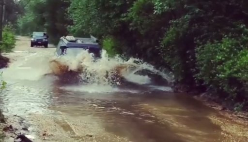
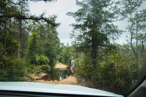
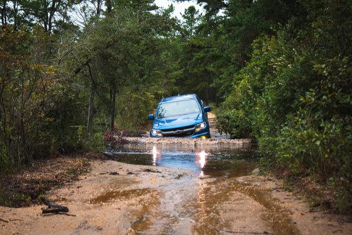
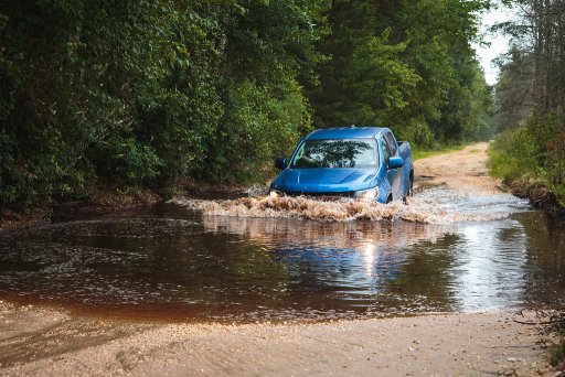
Well, the water crossings are hood deep at times. It’s best to take them slow and do not splash into them. Here’s a photo of the Mt Misery Water Crossing. You will be going the opposite direction than the direction these guys were going.

As for the sloppy mud, there are a few sections where you can sink a vehicle on 37s there. But luckily those sections have go arounds.

The Zillon Bypass will by pass a section of deep sloppy mud that has no go arounds. You are forced to go through those holes. One of them being a deep hole where I almost got my 4Runner on 33s stuck (bottomed out) and the other being where I got my FJ Cruiser on 34s stuck down to the doors. The spot where I got the FJ stuck, I highly recommend to go to the right and DO NOT go through the center hole unless you have a winch. Maxtrax and treds will not help you in this situation. If you go to the right, it is sloppy mud but it is not deep. Only issue with going to the right is that it’s VERY tight. You have to wiggle your Way between the trees. If I can squeeze a 5th gen 4Runner through there then anyone should be fine as long as they’re not a 4 door long wheel base truck lol.B054D6AB-4364-4AF3-8E95-11D3FEE89481.jpeg
 

Subarublu

Rank 0

Traveler I

60
NJ
Hey guys, and gals, I decided to create an “official” Trans New Jersey Trail thread. This is where you can find the “official” route and any route info you need to know. Also, this thread will be good for those to post info about the route; like road closures, detours, dangers, trees down, and anything else that may restrict access to the trail.

If anyone wants a copy of the route, it is free and available by sending me an email at xplorr313@gmail.com. I will accept donations if you feel inclined to donate to the beer fund.

Previously I charged for the route due to keeping the route out of the hands of those who were only looking to “off-road” or “wheel” illegally on state land. I received a lot of backlash from the off-roading / Overlanding community for charging for the route. I put over 2 years of my life into making this route, please stay on the path and DO NOT “off-road” or “wheel” off of the path. This could cause closures and could also land you in major trouble with the state, for example: a hefty fine or even vehicle impoundment. I’ve seen and heard about it happening. Do not think it won’t happen to you. The state does have trail cameras along some of the more “prone to off-roading” spots. You will get caught.

The route is current and up to date as of 9-12-18. The most recent revision of the route was done on 9-12-18. If you have any version older than 9-12-18 please reach out to me for an updated version. I will keep this post updated with the most recent version of the route.

I HIGHLY RECOMMEND THE LEADNAV APP FOR BEST THE BEST EXPERIENCE. LeadNav is only for iPhones and iPads. The route can be used on other devices, but the route was made with and for LeadNav.


For those of you who are just learning about the Trans New Jersey Trail, the trail is a 450+ mile route that spans from High Point, NJ to Cape May, NJ. The trail consist of asphalt, gravel, sand, dirt, and some mud. The trail is 100% legal for all street legal vehicles. This means you must be registered, insured, and compliant with all DOT regulations (headlights, taillights, seat belts, turn signals, and so on).

The TNJT can be completed in a Subaru as long as the driver is experienced. There is NOTHING complicated on this route. There ARE bypasses for those who do not have a snorkel or the ability to traverse deep mud holes. The bypasses are clearly marked as separate routes. The Zillon Bypass is recommended for those who do not wish to traverse down an extremely tight trail and do not want to risk the couple extremely sloppy mud holes along that part of the TNJT. The Zillon Bypass is 100% asphalt that bypasses the tight trail and sloppy mud holes.

The whole route CAN be done in 3 days. I completed the route in 4 days when I ran it start to end non stop in 2017. My 4th day on the trail only consisted of 50 miles and I could have just finished it on day 3.

The trail has 3 sections North, Central, and South. I consider the North section to go from High Point, NJ to Round Valley Reservoir (Spruce Run Recreation Area [campground]). The Central section to go from Round Valley Reservoir to Brendan T. Byrne State Forest (camping is available in Brendan T. Byrne State Forest). The South section to go from Brendan T. Byrne State Forest to Cape May, NJ. If you feel inclined to turn it into a 4 day trip, I recommend stopping at Belleplain State Forest for an overnight stay.

I do plan to offer 4 versions of the TNJT. A full length version, which is what I have been passing out to everyone, and the three sections. This will allow daytrippers to do the route one section at a time. I will post when the 4 versions are available. Right now just the whole route is available.

Anyone have any questions, please reach out to me by email or ask here!

Seriously, thank you for doing this!
 
  • Like
Reactions: Xplorr313

Xplorr313

Rank V
Founder 500
Launch Member

Enthusiast III

2,421
Burlington, NJ
First Name
Leon
Last Name
Jones
Member #

0313

Ham/GMRS Callsign
WQYY816
Seriously, thank you for doing this!
No problem!

And thanks to @Zillon again for the great photos, this is another shot of the Mt Misery Water Crossing. This time it’s going the direction you’ll be going if you’re doing the trail from top to bottom.F2C56FCA-4D71-4CE1-9038-7EF933E2959F.jpeg
 

Xplorr313

Rank V
Founder 500
Launch Member

Enthusiast III

2,421
Burlington, NJ
First Name
Leon
Last Name
Jones
Member #

0313

Ham/GMRS Callsign
WQYY816
UPDATE: The Route has been added to the original post. You can download it straight from there. The route will be updated periodically given if changes need to be made.
 

Zillon

Rank II

Enthusiast II

336
CNJ
First Name
Zack
Last Name
R
Gaia works great from my experience - I've been using it for my navigational purposes without any hitches. However, I am not using it as a turn-by-turn navigation, rather I'm using it as a track on a visual map. Works great for that.

@Xplorer313 has done a great job putting together this route for all of us - looking forward to seeing more people use it responsibly!
 

MuckSavage

Rank V
Launch Member

Member III

2,268
South Jersey, NJ, USA
First Name
Tim
Last Name
McG
Member #

15570

I had to take a run out to Laurie Road/Sooy Rd (per my map) just south of Rte 72 to Bear Swamp Hill in the southern portion of the TNJT. This stretch has many deep water crosses thanks to last weeks rain. Also, there’s some blow-down trees that may pose a problem. It was late in the evening or I would’ve cleared the trail.
 
  • Like
Reactions: Xplorr313

Xplorr313

Rank V
Founder 500
Launch Member

Enthusiast III

2,421
Burlington, NJ
First Name
Leon
Last Name
Jones
Member #

0313

Ham/GMRS Callsign
WQYY816
I had to take a run out to Laurie Road/Sooy Rd (per my map) just south of Rte 72 to Bear Swamp Hill in the southern portion of the TNJT. This stretch has many deep water crosses thanks to last weeks rain. Also, there’s some blow-down trees that may pose a problem. It was late in the evening or I would’ve cleared the trail.
Sooy Rd has always had deep holes along it. Sounds like you’re still running on one of my original versions of the TNJT Route. The route is different now and there is no more traversing down through Hidden Lakes or Sooy rd. Thanks for the update though!
 
  • Like
Reactions: Subarublu

GXOutlaw

Rank I
Launch Member

Traveler I

233
West New York, NJ
Member #

15016

@explorer313 thank you for putting all of this together. I cant imagine how much time it must have taken to plan and approve it.

I have an 06’ gx470 with all seasons. I’m planning on upgrading to Nittos ridge grapplers when a sale pops up, but until then, do you think I’d be ok on northern part of the trail? I was thinking of going this saturday to get a feel for things. This would be my first overlanding experience and the GX is my dd so I dont want to kill it, lol
 

MuckSavage

Rank V
Launch Member

Member III

2,268
South Jersey, NJ, USA
First Name
Tim
Last Name
McG
Member #

15570

@GXOutlaw on the northern portion you’ll be absolutely fine. I did it in a Commander w/265/70-17 Nitto Terra Grapplers & I’ll admit, I’m the guy that @Xplorer313 talked about that had to exit the trail for fuel. Thanks to him for routing me to a gas station. That was the only situation we ran in to. I ran the South portion (Rte 72 & South) on a Combo of the Commander & an XJ (31” Grabber AT2’s, Rear Locker winch) (no need for winch if you pick your seasons)
 
  • Like
Reactions: GXOutlaw

Bearmanpig

Rank I
Launch Member

Traveler I

233
White Marsh, MD, USA
Member #

14457

Thanks for doing all the work on this, can't imagine all the effort to plot out 450 miles. Looking at doing my first overland trip on this with a stock 2018 Tacoma. This would be a solo trip with the wife and would be doing it next week. I have a pair of maxtraxs but that's about it. Any advice or think i'll run into any issues?

Edit - How do you donate?