

Member III
We drove through there once a few years ago. Keep saying we are going back, but haven’t made it yet. I heard they have some nice hiking trails thoughthat’s exactly where we went.
Member III
We drove through there once a few years ago. Keep saying we are going back, but haven’t made it yet. I heard they have some nice hiking trails thoughthat’s exactly where we went.
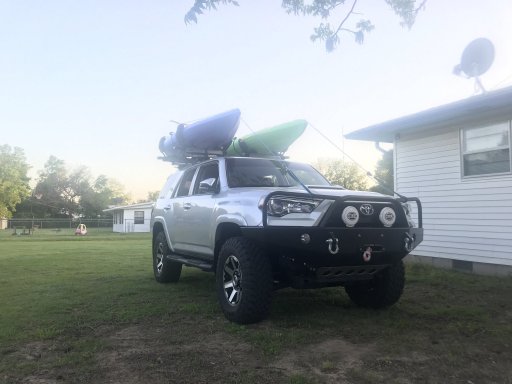
Nice set up.We should try and do a meetup and knock out the whole OAT in a weekend. Also Some pics of the camp setup from last weekends Social Distancing!View attachment 148607
View attachment 148608
View attachment 148605
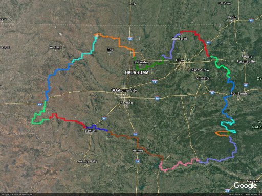
Here's a Google Earth picture of the Oklahoma Adventure Trail. I took off all the way points and markers to make the route easier to see. It's something like 1,700 miles.This may be a silly question, but I'm not familiar with "OAT". Can you tell me what that is?
Member III
the small section that we did awhile back was more fun than we expected. There was quite a bit of stuff to see along the way (ft washita/Denton dam/texoma/carpenters bluff bridge/multiple other old bridges) that made our section from sulphur to Boswell take about 7 hours. We also stop for photos of things along the way as we have that hobby too.Nice set up.
I want to do the OAT as soon as the shut down is over and we can travel. I also want to throw in a side trip to Black Mesa to finish out a trip that we didn't have enough time to make from a few years ago.
I've been looking at the OAT in Google Earth. I'm thinking it would take a good solid week to do.
I'm out of work until August so I need to get out of the house and clear my head once the shut down is over. My daughter wants to go, my wife is 50/50 right now.
Member III
Gaia puts it at 1509 miles...It's something like 1,700 miles.


Contributor I
I've never heard of it and I've lived in OK a long time. Learn something new every day! Thank you for sharing that with me. That would be a neat way to explore more of Oklahoma.Here's a Google Earth picture of the Oklahoma Adventure Trail. I took off all the way points and markers to make the route easier to see. It's something like 1,700 miles.
View attachment 148635
And the Google Earth KML file that I made.

Enthusiast III
Hello I just seen this and hope this is something maybe this fall.Ok ladies and gentlemen, I am aware of the current concerns going on around the world. At this point due to lack of commitment/interest, and the general safety of any and all involved I am thinking that the event needs to be postponed until a later date when the world is not freaking out and running out of TP.
Enthusiast III
Ive done the section from bartlesville to great salt plains in 2 seperate sections. started around stillwater both times.1 day for each section, our average speed was around 13mph. We were enjoying the journey. The next section on my list is from I-40 down to Hugo. With a stop around broken bow to finish my exploration of the Forestry trails.Here's a Google Earth picture of the Oklahoma Adventure Trail. I took off all the way points and markers to make the route easier to see. It's something like 1,700 miles.
View attachment 148635
And the Google Earth KML file that I made.
How long you reckon it would take to do it straight through? A week? give or take?Ive done the section from bartlesville to great salt plains in 2 seperate sections. started around stillwater both times.1 day for each section, our average speed was around 13mph. We were enjoying the journey. The next section on my list is from I-40 down to Hugo. With a stop around broken bow to finish my exploration of the Forestry trails.
Enthusiast III
To see everything and depending on time of year. some of the dirt roads become slimmy in the wet. When my tires hit the dirt I tend to slow down.How long you reckon it would take to do it straight through? A week? give or take?

Traveler III
16636

Enthusiast I
Is that like a state park or camp site? How would I get there? What do I google to get that place?that’s exactly where we went.
Enthusiast I
that’s exactly where we went.
 www.redrockcanyonadventurepark.com
Member III
Had no idea they had a website. We drove through years ago looked pretty nice. We were just passing through on way to great salt plains state park that day though so we didn’t look around a lot.Red Rock Canyon Adventure Park | glamping | 116 Red Rock Canyon Road, Hinton, OK, USA
Red Rock Canyon Adventure Park offers glamping, rv camping, overland camping, tent camping, 12 miles of trails, music, movies, swimming, fishing, and other outdoor activities.
Member III
Enthusiast I
www.redrockcanyonadventurepark.com
LUCKY!!We are headed out west on the OAT starting around turner falls in the morning! Planning to casually work out way around it, camping along the way. If anyone else happens to be out there and sees us, give me a shout! I’m not hard to spot. Lol
Enthusiast I
Member III
Welcome! i am in stratford. we are nearly neighbors!New member here just joined. I am in Oklahoma. Southern Oklahoma. 50 miles south of OKC
Enthusiast I
Awesome. Need to try to meet up sometime after this quarantine is over!Welcome! i am in stratford. we are nearly neighbors!New member here just joined. I am in Oklahoma. Southern Oklahoma. 50 miles south of OKC
