Mojave Road trip - March 2017

  • HTML tutorial

Best weekend in March 2017 to go?

  • March 3, 4, 5

    Votes: 1 14.3%
  • March 10, 11, 12

    Votes: 1 14.3%
  • March 17, 18, 19

    Votes: 2 28.6%
  • March 24, 25, 26

    Votes: 3 42.9%
  • During the week would work better for me

    Votes: 0 0.0%

  • Total voters
    7
  • Poll closed .

O.Dfj

Rank VI
Launch Member

Influencer III

3,689
Foothill Farms
Member #

1466

Agreed. I say we designate a few "leads" for different subjects and then have those "leads" have a phone call or something. Easier than trying to delegate to 20 people or someone taking up everything on their own.

Maybe something like this:

Permits:
Route:
Vehicles:
Requirements:
Roster:
Etc:
Etc:

Something like that? Without overplaying too much or anything so like you said, we don't lose the spontaneity that comes from these kind of events, but also so we don't neglect or let anyone feel left out? Thoughts?

I will be taking care of all the permit stuff. Once we have a final count I will call and sort everything out. I will also happily help in any other area that is needed, I have never navigated the trail, but by navigation skills are fairly good, so I can plot a few maps or draw out some routes with a set of waypoints or whatever it is we decide on doing.
The trail is easy to follow. The biggest issue I see is camp sites and a time schedule. There is a lot to see and a lot of trail to complete. When we broke down the trail into thirds. First day trail head to mojave camp second day mojave camp to afton canyon camp ground and the third day afton to camp cady.

Sent from my LGMS631 using OB Talk mobile app
 
  • Like
Reactions: pabloquiros

Scott

Rank VI
Launch Member

Influencer II

3,921
Bates City, MO, USA
First Name
Scott
Last Name
Heiser
Member #

2486

I have never run this trail but I am happy to help with Any logistics like rig count or required items to have for this run. Also we need to decide on comms. I hope to have my ham license by the trip but if not I will have frs radios and a cb.

Sent from my LG-H810 using Tapatalk
 

GregS

Rank I
Launch Member

Contributor I

233
Inland Empire, CA
Member #

2321

I most recently ran this trail on Veterans Day weekend (Nov, '16). I have 2 GPX files to contribute if needed. 1 of the files is the true course going east to west and the 2nd, also east to west, contains the detour around the washout just after Fort Piutte in case the winter rains wash that section out again after this winter's rains. Albeit, the Mojave only receives 5 inches of rain per year, but when it does rain it falls heavy and flash floods surge. So it's good to have alternate routes. When we ran it we crossed through the "washout" just fine. Also, I wouldn't dare cross Soda Lake with even a small amount of rain on the lake bed. It's not only corrosive but the mud is like quick sand and getting stuck in the middle of S.L. could possibly cost you your rig. Anyhow, looking forward to all the photos. Looks like a lot of rigs going. Interested how you all feel about such a large group on the Mojave when it's all said and done. Cheers!
 
Last edited:

VCeXpedition

Rank V
Launch Member

Off-Road Ranger I

2,932
Pleasant View, UT, USA
First Name
Dan
Last Name
Rich
Member #

0582

Ham/GMRS Callsign
K6DHR
@GregS I'd welcome those files, I have some others but they seem to be in bits and pieces, can you either post them or direct message me those? Thanks for your insight and I'm glad to hear that the washout is driveable again. This many vehicles will be a challenge for sure but what a great group!
Cheers.
 

GregS

Rank I
Launch Member

Contributor I

233
Inland Empire, CA
Member #

2321

@GregS I'd welcome those files, I have some others but they seem to be in bits and pieces, can you either post them or direct message me those? Thanks for your insight and I'm glad to hear that the washout is driveable again. This many vehicles will be a challenge for sure but what a great group!
Cheers.
Here you go, bud. You should have 4 routes in that file. 1 of them is the full run WITH detour. The other 3 are how I did the run without the detour and are broken down into 3 days (1 route per day). Days/Routes 1 and 2 stop at camp sights, and day 3 ends after the water crossing at the hwy. Its the day 2 route that's the only difference from the route with detour. Day 2 route goes through the washout which like I mentioned was easily passable last month. There were signs that said "road closed" prior to the washout but after talking with NPS they mentioned the signs are there to keep the mini vans out. Haha. Also, the permit is 80 bucks and I suggest filing for it early. When my pal called they told him to put in for the permit at the very least 2 weeks before your trip. Let me know if you have any issues with the file or have more questions. Cheers!
 

Attachments

Last edited:

pabloquiros

Rank V
Launch Member
Supporter

Advocate II

1,908
Morro Bay, California
Member #

1783

Here you go, bud. You should have 4 routes in that file. 1 of them is the full run WITH detour. The others are days 1, 2, and 3 with days 1 and 2 ending at camp sights, and day 3 ending after the water crossing at the hwy. Day 2 goes through the washout which like I mentioned was easily passable last month. There were signs that said "road closed" prior to the washout but after talking with NPS they mentioned the signs are there to keep the mini vans out. Haha. Also, the permit is 80 bucks and I suggest filing for it early. When my pal called they told him to put in for the permit at the very least 2 weeks before your trip. Let me know if you have any issues with the file or have more questions. Cheers!
Hey guys what software/app do you use to manipulate these files? Or are you popping them into an actual GPS?

Sent from my Nexus 6P using Tapatalk
 

GregS

Rank I
Launch Member

Contributor I

233
Inland Empire, CA
Member #

2321

I
Hey guys what software/app do you use to manipulate these files? Or are you popping them into an actual GPS?

Sent from my Nexus 6P using Tapatalk
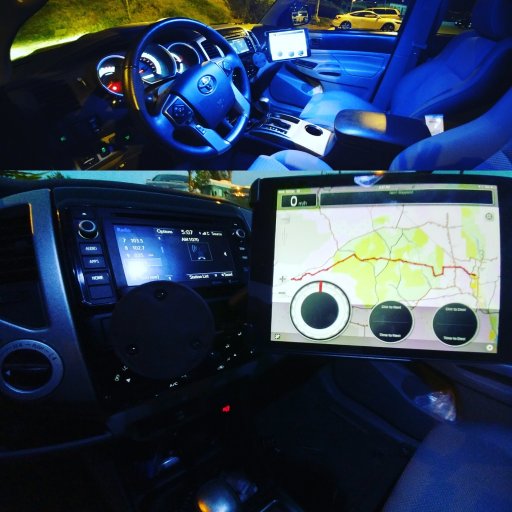
I use the LeadNav app on my iPad mini 2 and the map I press it against is California Trail Map. LeadNav app was 20 bucks and accurate within 6 feet. California Trail Map is like 50 or 60 bucks for all the maps they have out now, all maps they'll come out with in the future and all the map updates for LIFE. Both worth their price immensely. Google: California Trail Map for videos
My setup:

IMG_20161109_174932.jpg
 
Last edited:

VCeXpedition

Rank V
Launch Member

Off-Road Ranger I

2,932
Pleasant View, UT, USA
First Name
Dan
Last Name
Rich
Member #

0582

Ham/GMRS Callsign
K6DHR
Hey guys what software/app do you use to manipulate these files? Or are you popping them into an actual GPS?

Sent from my Nexus 6P using Tapatalk

I'm trying to familiarize myself with BackCountry Navigator on my Samsung Tab A. If that fails, as it seems to be not very intuitive, I may try Gaia app.

I'll check it when I have some time to go through it and understand Greg's comments. I'm glad to hear the "Detour" is not so much. Sounds like some fun actually, but it might be worth checking out the actual detour.

Dan.
 
  • Like
Reactions: Zargon and GregS

Zargon

Rank V
Launch Member

Pathfinder I

I'm trying to familiarize myself with BackCountry Navigator on my Samsung Tab A. If that fails, as it seems to be not very intuitive, I may try Gaia app.

I'll check it when I have some time to go through it and understand Greg's comments. I'm glad to hear the "Detour" is not so much. Sounds like some fun actually, but it might be worth checking out the actual detour.

Dan.
I ran the original detour earlier this summer and I didn't enjoy it quite as much as the rest of the trail imo.


Sent from my Nexus 6P using Tapatalk
 

GregS

Rank I
Launch Member

Contributor I

233
Inland Empire, CA
Member #

2321

I'm trying to familiarize myself with BackCountry Navigator on my Samsung Tab A. If that fails, as it seems to be not very intuitive, I may try Gaia app.

I'll check it when I have some time to go through it and understand Greg's comments. I'm glad to hear the "Detour" is not so much. Sounds like some fun actually, but it might be worth checking out the actual detour.

Dan.
Gaia is another great one. I was so impressed with LeadNav, however, that I don't think I'll go back to Gaia.
 
  • Like
Reactions: Zargon

VCeXpedition

Rank V
Launch Member

Off-Road Ranger I

2,932
Pleasant View, UT, USA
First Name
Dan
Last Name
Rich
Member #

0582

Ham/GMRS Callsign
K6DHR
Gaia is another great one. I was so impressed with LeadNav, however, that I don't think I'll go back to Gaia.

Does LeadNav work on Android as well as it does on iPad? I'm willing to buy in, sounds decent but I know HEMA doesn't work well on Android yet, so....
 
  • Like
Reactions: Zargon

Huerta32

Rank I

Contributor III

154
I'd like to tag along, a long trip before my daughter is born would be awesome

Sent from my SM-G900P using Tapatalk
 
  • Like
Reactions: Zargon