Mackenzie Trail BC - want to do it?

  • HTML tutorial

Ubiety

Rank VI
Member

Explorer I

5,221
Sammamish, WA, USA
First Name
Greg
Last Name
Ubiety
Member #

6193

Ham/GMRS Callsign
Ribs
I recall Bella Coola had the worst mosquitos I've ever seen, but that was on the coast,
the Caribou is much higher, Colorado style, closer to the stars and all.
On our AlCan trip the mosquitoes were not that bad (knock on wood). There was one spot before The Yukon where they were relatively small but were thick and bouncing off of our helmet face shields just standing there. We did not stick around long. Later is always better for bugs in our experience; one of the reasons that we do our annual trip in Sept.

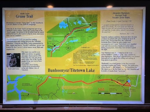
Ok, will save a post. Attached is the latest and greatest GPX file. I hope route colors are making it to you! My routes are purple and all lead out from Quesnel; there is a new one which is the bailout point near the Kluskus Village. This is the route EO took to go get gas mid trip. Added a bunch more waypoints including where EO camped each night and some of the water/bog crossings they showed. I turned all of the EO route chunks red and all the others black (left for reference). Added more mountain peaks because I am me and think those could be good reference points or at least give us the real name to yack about... Its a work in progress and continues to improve.

GPX viewer
 

Attachments

Ubiety

Rank VI
Member

Explorer I

5,221
Sammamish, WA, USA
First Name
Greg
Last Name
Ubiety
Member #

6193

Ham/GMRS Callsign
Ribs
The built in OB viewer here does not do a good job of showing everything in the GPX. Give the file a try in Gaia or Google Earth or you favorite nav software. I'm going to reorganize the structure of the fie a bit and made that will help...
 

shortbus4x4

Rank II

Enthusiast III

473
I spent part of one summer at my grandparents gold claim near Central AK and can remember how big and ferocious the mosquitos were. You did your business in the outhouse very quickly. Definitely will need long sleeves and mosquito netting.
 
  • Like
Reactions: Ubiety

Ubiety

Rank VI
Member

Explorer I

5,221
Sammamish, WA, USA
First Name
Greg
Last Name
Ubiety
Member #

6193

Ham/GMRS Callsign
Ribs
Just watched this video; some different perspectives. What is interesting is their video starts with this sign and I have seen the same in other videos - this sign is what I think of as the beginning when it is really a good way into the trail - just about where the red EO tracks start in the GPX file (by Pelican Lake). Based upon the "you are here" on the sign I have been able to mark it in the GPX file.

Our planning should include some common mech stuff and fluids. They did a lot of winching but did not see any tree cutting or mosquito netting... And Max Tracks, probably a necessity.

I thought the "grease'" in grease trail referred to the mud; not so. Read the sign!


1586060868151.jpeg
 

Ubiety

Rank VI
Member

Explorer I

5,221
Sammamish, WA, USA
First Name
Greg
Last Name
Ubiety
Member #

6193

Ham/GMRS Callsign
Ribs
Another good series that I have seen before; very informative. Just started re-watching and already they have helped me mark Sylvia's Truck Stop on the map. And they call the sign in my last post the "trailhead". I am thinking more and more that sign is the beginning for 4x4 folks.

A thought. I'll start a Google Sheet workbook to track stuff. Would be good to have provisions, supplies, needs all visible and accounted for.
Have a diff breather tube extender kit in the virtual cart and should add some Max Tracks. I need to figure out a way to cloak lift/rims/tires/snorkel and the checkbook so wifey does not notice these NEEDED upgrades. I am talking NEED and not WANT here ;)

Well at least I have something to do ;)
 
Last edited:

Munga Brown

US Northwest Region Member Rep Oregon
Launch Member

Enthusiast III

1,003
Central OR Coast
First Name
Martin
Last Name
S.
Member #

21803

Another good series that I have seen before; very informative. Just started re-watching and already they have helped me mark Sylvia's Truck Stop on the map. And they call the sign in my last post the "trailhead". I am thinking more and more that sign is the beginning for 4x4 folks.

A thought. I'll start a Google Sheet workbook to track stuff. Would be good to have provisions, supplies, needs all visible and accounted for.
Have a diff breather tube extender kit in the virtual cart and should add some Max Tracks. I need to figure out a way to cloak lift/rims/tires/snorkel and the checkbook so wifey does not notice these NEEDED upgrades. I am talking NEED and not WANT here ;)

Well at least I have something to do ;)
This is the series I've seen in the past. Good stuff all around.
 
  • Like
Reactions: Ubiety

Ubiety

Rank VI
Member

Explorer I

5,221
Sammamish, WA, USA
First Name
Greg
Last Name
Ubiety
Member #

6193

Ham/GMRS Callsign
Ribs
[/QUOTE]
This is the series I've seen in the past. Good stuff all around.[/QUOTE]
Super informative, enjoying the voice over explaining what and where is happening. Decided re-watch was good investment of time. A lot of the other videos are only action clips with no unifying story. ☹

(App .54 test)
 

Ubiety

Rank VI
Member

Explorer I

5,221
Sammamish, WA, USA
First Name
Greg
Last Name
Ubiety
Member #

6193

Ham/GMRS Callsign
Ribs
Interesting note on times. Expedition Overland’s GPS data is time stamped mid/late August and Off-road Origins signed their name in a cabin putting their start date at beginning of Sept.

In EO’s series they slept at an airstrip and a family came out in the morning. I think these are the Chadwells where the off-road origins guys rented and signed the cabin. It’s all in the GPX.
 

Ubiety

Rank VI
Member

Explorer I

5,221
Sammamish, WA, USA
First Name
Greg
Last Name
Ubiety
Member #

6193

Ham/GMRS Callsign
Ribs
Latest and greatest GPX files. Added purple route or two to highlight routes of ingress/outgress to the MT. Added a few more waypoints - Sylvia's Truck Stop!, bogs, water crossings, etc.

GPX viewer
 

Attachments

shortbus4x4

Rank II

Enthusiast III

473
Bringing this back up now that the Covid shut downs are over. Any interest in doing this? My summer of 2023 is booked but thinking maybe August/September 2024 timeframe.
 
  • Like
Reactions: Ubiety

Ubiety

Rank VI
Member

Explorer I

5,221
Sammamish, WA, USA
First Name
Greg
Last Name
Ubiety
Member #

6193

Ham/GMRS Callsign
Ribs
Maybe… Gotta go to YT and look up some videos to recall just what we would be getting ourselves into ;)
 

shortbus4x4

Rank II

Enthusiast III

473

 
  • Like
Reactions: Ubiety

shortbus4x4

Rank II

Enthusiast III

473
Is this still a go, if so what’s the date?
Probably the last two weeks of August or the last week of August/first week of September 2024. I plan on going all the way to Bella Coola and riding the ferry back to Vancouver. Thinking 3-5 vehicles for this. Of course this all depends on fire and rain, too much of either and it will be a no go.
 

frankspinz

Rank I

Enthusiast I

Probably the last two weeks of August or the last week of August/first week of September 2024. I plan on going all the way to Bella Coola and riding the ferry back to Vancouver. Thinking 3-5 vehicles for this. Of course this all depends on fire and rain, too much of either and it will be a no go.
There will be a traffic jam on the trail ! ;) Keep us informed of your planning . Cheers !