

Enthusiast III
Enthusiast III

Influencer II
Enthusiast III
100% correct. Garmin is trying to exploit the overlanding community with a ridiculously expensive GPS. Gaia works great on a pad or phone of your choosing. I still have a GPS as a back up, actually one I didn’t mount on one of my bikes so it’s a motorcycle Garmin in my JeepIMHO what is the point? Any of the 3rd party apps in the Overlander can be run on any smart device. If you like Garmin maps great. If not Gaia has plenty of other options equal to or greater than what Garmin offers. I have a Garmin InReach but never really use the maps from the Earthmate app I prefer what Gaia offers.

Member III
Enthusiast III
I'm running both. I just got them and am still learning how to use them. When I can afford it, I tend to overdo things a bit. Especially when it comes to safety/recovery, so I'm also looking at it as having them back-up more than complement each other. So far, I'm finding the Overlander easier to use/understand how to use and finding more detailed maps in Gaia. We just did the Titus Canyon Trail in Death Valley. It's a well known, well traveled, 27 mile dirt road through some amazing terrain. It did not (or I couldn't get it to) show up on the Overlander. It did show up on GAIA. One thing I do like about the Overlander is that I can use the "street map" side for getting me to the trailhead & then the "offroad" side to follow the trail. I think this will be great for areas we aren't familiar with.
Enthusiast III
Read this and save yourself $600That's good to know. I'll admit that I struggle with GAIA and hope that I can use the Garmin as my "safety net". Especially if I haven't downloaded any areas that I may wish to explore.

Enthusiast III

Member I

Explorer I
Create a route in Gaia and then tell it to download maps along the route. Simple and gives pretty good coverage on either side of your route. Make sure that all of the map layers that you want are currently active in Gaia or they will not be downloaded.The down side, however, is you have to download the maps, which can be pretty unrealistic for a long distance OTR trip.
Explorer I
Explorer I
I believe so but have been paying for so long that I don't remember. Pretty sure what you get from paying is more/better maps and not additional app functionality.All in the free version? Wow, ok, thanks. I'll try it as soon as I have an opportunity
I believe so but have been paying for so long that I don't remember. Pretty sure what you get from paying is more/better maps and not additional app functionality.
Let us know what you figure out!

 help.gaiagps.com
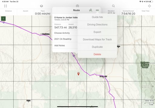
Found it. Ok. When you tap on the map, on the route, the menu pops up and scroll to Guide Me. Takes you from wherever you are, to the route and then along it. Nice feature. I was getting tired of moving that map, but didnt want to try and feature hunt while I was out there.I believe so but have been paying for so long that I don't remember. Pretty sure what you get from paying is more/better maps and not additional app functionality.
Let us know what you figure out!
Tap this icon and it will center the map as well as change orientation of the map.Found it. Ok. When you tap on the map, on the route, the menu pops up and scroll to Guide Me. Takes you from wherever you are, to the route and then along it. Nice feature. I was getting tired of moving that map, but didnt want to try and feature hunt while I was out there.
Thanks!
Yep. I'd figured that and some other things out. Mainly the Guide Me feature was what I was looking for- something the ON road gps units do automatically. So it's a win!Tap this icon and it will center the map as well as change orientation of the map.
View attachment 180933


