Continental Divide Trail

  • HTML tutorial

KonzaLander

Rank VI
Member

Traveler II

3,402
Junction City, Kansas, USA
Member #

15814

Ham/GMRS Callsign
KE0EBF
Just finished running the route about a week ago. We were on the trail for three weeks. Fantastic route.
I spent a week along part of the CDR and part of my own routing in Colorado not to long ago. I don't understand why most of the CDR tracks send folks so far east in Southern, CO... away from the divide.

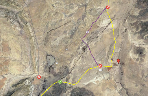
I did have a problem with private property postings about 30 miles outside Grants, NM as we were headed north. Not wanting to risk it, we turned around and drove highway through the Navajo Reservation towards Cuba, NM. I had researched the heck out of the route and determined that portion should have been on public county roads. Did you encounter any similar issues? The private property sign was posted next to a cattle guard right here: Google Maps

We met many riders from the Great Divide race. Ironically, they were usually sitting under a shade tree :sunglasses:
 
Last edited:

Rollin Dirty Overland

Rank III
Launch Member

Enthusiast III

676
Mesa, AZ
First Name
Jim
Last Name
G
Member #

14740

Ham/GMRS Callsign
W7RDO
Yep. I know the area. It's a case of private ranch with public road access through it. General rule on ranch land is leave gates how you found them, unless there is a sign stating how they would like the gate to remain. If it's not a public road, you'll almost always find a sign informing to stay out.
 

KonzaLander

Rank VI
Member

Traveler II

3,402
Junction City, Kansas, USA
Member #

15814

Ham/GMRS Callsign
KE0EBF
I am very familiar with public roads through private property. The best roads and views Kansas has to offer are the same deal. My assumption was the same for this road in NM. The part which turned me away was the sign stated, 'No Trespassing for ANY reason!' I had also missed a turn before this and encountered no trespassing signs that mentioned the use of explosives. I'll make a note on my map about the public road through ranch land.

 

Rollin Dirty Overland

Rank III
Launch Member

Enthusiast III

676
Mesa, AZ
First Name
Jim
Last Name
G
Member #

14740

Ham/GMRS Callsign
W7RDO
I am very familiar with public roads through private property. The best roads and views Kansas has to offer are the same deal. My assumption was the same for this road in NM. The part which turned me away was the sign stated, 'No Trespassing for ANY reason!' I had also missed a turn before this and encountered no trespassing signs that mentioned the use of explosives. I'll make a note on my map about the public road through ranch land.

Doh!

Well then they should post a corresponding sign on the north end. Also they should tell the Continental Divide mountain bike race that they need to re-route as well. We were travelling north to south--for the second time in three years--and saw no such warning.

Looking at the map, hooking around on 75, a couple hundred yards behind the cattle guard, would put you right back on the "official" route in a mile or two. Through that cattle loading facility is an unnecessary routing anyway.
 
  • Like
Reactions: KonzaLander

KonzaLander

Rank VI
Member

Traveler II

3,402
Junction City, Kansas, USA
Member #

15814

Ham/GMRS Callsign
KE0EBF
Doh!

Well then they should post a corresponding sign on the north end. Also they should tell the Continental Divide mountain bike race that they need to re-route as well. We were travelling north to south--for the second time in three years--and saw no such warning.

Looking at the map, hooking around on 75, a couple hundred yards behind the cattle guard, would put you right back on the "official" route in a mile or two. Through that cattle loading facility is an unnecessary routing anyway.
I thought the routing through the cattle pens was odd (and intrusive) so I planned to go around. Next time I am through the area I'll trust my research a bit more through the ranch land.

The sign referencing explosives is the left "x" on the map. Looks like some sort of mining/excavation work north of there on the aerial view.

1563824377524.png

Thank you for the feedback and discussion. I am looking forward to running the whole route someday.
 

Tudelum48

Rank I

Traveler I

Our CDR trip got sidetracked this year due to medical issues. Made it to El Paso and had to turn back. Going to attempt it again this July. My route is the same as the yellow track shown above. Is the consensus its OK to use that track?
 

Rollin Dirty Overland

Rank III
Launch Member

Enthusiast III

676
Mesa, AZ
First Name
Jim
Last Name
G
Member #

14740

Ham/GMRS Callsign
W7RDO
I've finally cut through my queue of videos and have started on our CDT trip. I don't know how many parts it will break out into, at least five, possibly more. The first will be out in a couple weeks...hopefully less. I'm a slow video editor. I'll post a link here as I get them published.
 

Rollin Dirty Overland

Rank III
Launch Member

Enthusiast III

676
Mesa, AZ
First Name
Jim
Last Name
G
Member #

14740

Ham/GMRS Callsign
W7RDO
@Rollin Dirty Overland - Looking forward to your video clips. I am planning to run the route again this summer/fall, starting at Salida and heading north. Any got-ya's in WY?
Not in Wyoming that I can recall. The only real trouble from the GPSKevin route is in lower Montana and upper Idaho. Montana has a bit of trail that is so steep, it is very unlikely a truck can climb it, and in Idaho there is a section that is OHV only. Easy re-routes on both.
 
  • Like
Reactions: KonzaLander

Rover7284

Rank VI
Launch Member

Influencer I

3,201
Shorewood, IL
First Name
Brandt
Last Name
Fick
Member #

7284

Howdy Everyone, just catching up with this thread. OB member Brandon Jones has done both the TAT and continental divide trails. Documented both on his You Tube channel. Can check him out at Trailspin TV on YT.
 

Rollin Dirty Overland

Rank III
Launch Member

Enthusiast III

676
Mesa, AZ
First Name
Jim
Last Name
G
Member #

14740

Ham/GMRS Callsign
W7RDO
Ok, the first of I don't know how many parts is done. Have a look. This is the run up from Phoenix to the Canadian border. The real goodies will be starting on the next part as we get rolling off road, headed south.


Rollin Dirty Overland

Rank III
Launch Member

Enthusiast III

676
Mesa, AZ
First Name
Jim
Last Name
G
Member #

14740

Ham/GMRS Callsign
W7RDO
Here is Part 2. Our first couple days were....interesting. Mostly just great, rolling along the trail, taking in the scenery, but then things got interesting.


Rollin Dirty Overland

Rank III
Launch Member

Enthusiast III

676
Mesa, AZ
First Name
Jim
Last Name
G
Member #

14740

Ham/GMRS Callsign
W7RDO
Part 3 of the Great Divide Trail series is (finally) up. I hope you like it. We're starting to get into a stride now that the first few days on the trail are behind us. No more overcrowded camp sites (for now). No more shifty looking folks following us up a dead-end trail. And, most importantly, no more lost wallets!


Rollin Dirty Overland

Rank III
Launch Member

Enthusiast III

676
Mesa, AZ
First Name
Jim
Last Name
G
Member #

14740

Ham/GMRS Callsign
W7RDO
A new video is finally loose.

Yeah! Yeah! Its been a while. We decided to take a break from editing and get some other behind-the-scenes stuff sorted out with our COVID downtime. Well, here we are back on track and hitting it!


Be sure to subscribe to our YouTube channel to keep up with the latest disfunction that is Rollin Dirty Overland.
 

BROGAN

Rank I
Launch Member

Member I

233
Texas, USA
First Name
Logan
Last Name
BROGAN
Member #

16772

So I looked through this old thread. Id like to pick up the "Continental Divide" trail from Durango, CO and take it North to Yellowstone next July 2021, so Im in the planning phase. But as far as I can tell, no one has actually posted any actual trail routes at all here. Are these routes some sort of guarded secret? I suppose it takes work and effort to map your own trail, so I would be willing to pay for that service if its not freely available somewhere on the internet. Is the Hema App the way to go? Do they have a good trail mapped out?
 
  • Like
Reactions: Laud

Laud

Rank VI
Launch Member

Influencer I

3,145
Southeast Arlington TX
First Name
Laud
Last Name
Maroney
Member #

7010

Ham/GMRS Callsign
-KG5QHC-
Service Branch
Air Force and Army
So I looked through this old thread. Id like to pick up the "Continental Divide" trail from Durango, CO and take it North to Yellowstone next July 2021, so Im in the planning phase. But as far as I can tell, no one has actually posted any actual trail routes at all here. Are these routes some sort of guarded secret? I suppose it takes work and effort to map your own trail, so I would be willing to pay for that service if its not freely available somewhere on the internet. Is the Hema App the way to go? Do they have a good trail mapped out?
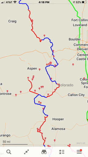
A bud of mine mapped it with Hema. He was the photojournalist that captured the story. I have it on file, but it’s not mine to give. And even though I share lots of routes, I can tell you, it is much more gratifying building and following your own route. The CDT and BDR share a lot of roads. This would be a great start.
You should be able to work with this though...E2EB1F8B-F6D0-49DE-8F5A-4A484A1DBF1C.png
 
Last edited:

BROGAN

Rank I
Launch Member

Member I

233
Texas, USA
First Name
Logan
Last Name
BROGAN
Member #

16772

Yeah no worries. I was just a little frustrated yesterday I suppose. A little more internet searching and I have the CDR from Hema. He posted them freely available online, on this youtube clip. So I will be posting them here for the future people who come here looking for help finding the CDR route.

Link to the YouTube clip from Hema

Link to the GPX, KML on Hema, CDR Pt 1

Link to the GPX, KML on Hema, CDR Pt 2

Like you said, I have shared routes, I have made routes, others have shared routes with me. That's what the overland community is all about, and the gent who started this thread came here specifically requesting route info and nobody really gave him any, they just suggested blogs to check out.

I also agree that making your own route is incredibly gratifying and rewarding. But I also have a new baby who will be 14 months when I take this trip, a full time+ job, and many responsibilities on my plate at the moment, so time is precious to me. If I can get GPX files like the ones I posted here, it is a huge help getting started. I will probably alter the route some. Also having files on a route that I know has been driven multiple time gives me a sense of security when I'm planning to have a 14 month old on the trail with me. Making my own trail wouldn't give me that security.
 

Rollin Dirty Overland

Rank III
Launch Member

Enthusiast III

676
Mesa, AZ
First Name
Jim
Last Name
G
Member #

14740

Ham/GMRS Callsign
W7RDO
Well that was a long and inexcusable delay, but it is what it is (was what it was?). Either way, priorities re-shifted and I'm able to get back to this little hobby of creating these videos. Hope you enjoy as we continue on our Continental Divide trip.