7 Hour Plane Crash Trail

  • HTML tutorial

laufer

Rank I

Contributor III

184
Chicago, IL, USA
First Name
Konstantin
Last Name
Läufer
Ham/GMRS Callsign
KD9IOJ
As an ORV route classified as > 12' wide, it's open to full-size vehicles. You can check on this map and click on individual route segments:


I'm not sure of its current condition, though.
 

GPG3

Rank II

Enthusiast III

473
Wisconsin
First Name
George
Last Name
Papageorge
7 Hour Plane Crash Trail (CRANDON to KEWEENAW)
 
  • Like
Reactions: coosabass2013

piratekiller

Rank I

Enthusiast I

201
Door County, WI, USA
First Name
scott
Last Name
smith
My wife and I are heading up to do this trail tomorrow. Anyone know of any current trail closures or current trail conditions? If not I will report back once our trip is done.
 
  • Like
Reactions: GPG3

piratekiller

Rank I

Enthusiast I

201
Door County, WI, USA
First Name
scott
Last Name
smith
We survived most of the trail. There was a lot more snow than I thought there would be and one section in northern WI was completely flooded out. We went as far as we could but eventually got stuck in the snow and spent 3+ hours digging ourselves out. Once we got out we dove a little further up trail and the snow just got deeper so we decided to call it as we don’t have a winch yet. There was a Jeep sized spot to pull off the trail so that was camp for the night. The next morning we turned around and made it back to the highway and ended up taking that the rest of the way to Copper Harbor. I am hoping to make another trip this summer to finish the trail and do some more exploring. Over all it was a blast and I would highly recommend this trail for anyone that wants an adventure.
 
  • Like
Reactions: Tyhaines421

abeta040

Rank 0

Contributor II

38
Madison, WI, USA
First Name
Albert
Last Name
Betancourt
@piratekiller Thanks for the update! Did you end up using that updated map in the comments above? I'm trying to coordinate an outing later this summer/fall and would love to start mapping and planning out my route now.
 

piratekiller

Rank I

Enthusiast I

201
Door County, WI, USA
First Name
scott
Last Name
smith
I did not. I ended up just using onX to map my route. I pretty terrible at remembering to start tracking my route and marking waypoints so I don’t have anything to share. I am planning on going back at some point this summer to do it again.
 

BMoris

Rank III

Enthusiast I

710
Wisconsin, USA
First Name
Bridger
Last Name
Moris
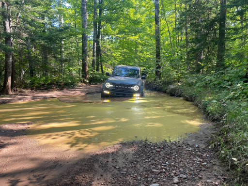
My wife and I just completed the trail. We didn't start in Crandon. Instead, we started just west of Pound, WI. This added around 100 miles of trail. I'll include the GPX file for anyone interested (I use Gaia for my mapping software). We were able to complete everything except the section of trail in northern Wisconsin by the UP border. We made it past the first creek crossing, but the second one was really bad. The creek diverted onto the trail and was about 50-75 yards of knee and thigh-deep water. We did not attempt it because we were alone. However, we did go around and backtracked to the other end. We cleared some downed trees, so if anyone makes it across it should be smooth sailing.

Update - I had the wrong GPX file for the +100. It's been updated to the correct one.

Update 2 (9/10/2023) V2 - I've updated the +100 to have more dirt roads and trails. All of the changes are south of Benson Lake Road. Route is approximately 65% gravel road, 25% dirt road/trail, 10% paved. Additionally, some of these roads are seasonal (closed late fall through early spring), so make sure they are open before using them.

Update (10/7/2023) V3 - Did some more exploring and added 15 miles of technical trails as well as some minor updates to the route.

GPX viewer
 

Attachments

Last edited:
  • Like
Reactions: piratekiller

spymoto

Rank 0

Contributor I

68
Watersmeet, MI, USA
First Name
Myk
Last Name
Brau
My wife and I just completed the trail. We didn't start in Crandon. Instead, we started just west of Pound, WI. This added around 100 miles of trail. I'll include the GPX file for anyone interested (I use Gaia for my mapping software). We were able to complete everything except the section of trail in northern Wisconsin by the UP border. We made it past the first creek crossing, but the second one was really bad. The creek diverted onto the trail and was about 50-75 yards of knee and thigh-deep water. We did not attempt it because we were alone. However, we did go around and backtracked to the other end. We cleared some downed trees, so if anyone makes it across it should be smooth sailing.

GPX viewer
A friend and I will be doing this trail in 2 weeks, over memorial weekend. I am wondering if I need to buy an ORV License and/or trail permit? Do you think it's a good idea to bring a chainsaw if there are any downed trees?
 

BMoris

Rank III

Enthusiast I

710
Wisconsin, USA
First Name
Bridger
Last Name
Moris
My wife and I just completed the trail. We didn't start in Crandon. Instead, we started just west of Pound, WI. This added around 100 miles of trail. I'll include the GPX file for anyone interested (I use Gaia for my mapping software). We were able to complete everything except the section of trail in northern Wisconsin by the UP border. We made it past the first creek crossing, but the second one was really bad. The creek diverted onto the trail and was about 50-75 yards of knee and thigh-deep water. We did not attempt it because we were alone. However, we did go around and backtracked to the other end. We cleared some downed trees, so if anyone makes it across it should be smooth sailing.

GPX viewer
A friend and I will be doing this trail in 2 weeks, over memorial weekend. I am wondering if I need to buy an ORV License and/or trail permit? Do you think it's a good idea to bring a chainsaw if there are any downed trees?
I didn't purchase any license, but I'm also not sure if one is required for any sections of the trail. The only section that might require one is the section on the Bill Nicholls trail. I think you'd be fine with a hand saw (I use a Silky), but a chainsaw would obviously make things faster. We only had to clear trees on the section in northern Wisconsin by the UP border.
 

THATCAMPINGGUY

Rank II
Launch Member

Member I

327
MO, USA
Member #

17613

My wife and I just completed the trail. We didn't start in Crandon. Instead, we started just west of Pound, WI. This added around 100 miles of trail. I'll include the GPX file for anyone interested (I use Gaia for my mapping software). We were able to complete everything except the section of trail in northern Wisconsin by the UP border. We made it past the first creek crossing, but the second one was really bad. The creek diverted onto the trail and was about 50-75 yards of knee and thigh-deep water. We did not attempt it because we were alone. However, we did go around and backtracked to the other end. We cleared some downed trees, so if anyone makes it across it should be smooth sailing.

Edit - I had the wrong GPX file for the +100. It's been updated to the correct one.

GPX viewer
How would you describe that extra 100 miles terrain wise? Headed up now from Tomah
 

Contributor III

124
Iowa, USA
First Name
Dan
Last Name
Dan
I just ran this last week. To anyone using ONX to follow the route, whoever logged the trail into Onx logged it wrong in several places(took highway when its supposed to be on trail, wrong trails altogether especially near copper harbor.) If you follow Onx route, you will hit a locked gate near copper harbor(because it has you on the wrong trail) I marked it on the app as a closed gate.

Other than that, I dont see any way that anyone could do this in 7 hours unless you are doing 60mph most of the time.(most of the way you will find that 30mph is more suitable depending on your vehicle)
I spent about 10 hours before bailing onto US41 to make some miles and catch sunset over the lake.(then I caught the rest of the trail the next morning)

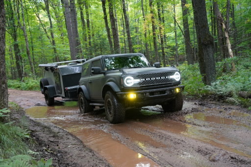
The only challenge I ever hit was near the WI/MI border, the trail got tight, rutted, and there were several fairly deep mud holes. I was in a Stock JKU on this trip instead of my normal rig, the water was deep enough that it came close to bottom of doors and exhaust was bubbling underwater but I made it.
One of the final sections out near rocket range has lots of water holes with firm bottom, they were all passable (for reference a suburu was following me) but some of them have the potential to be 4-5 feet deep or more if there is enough rain/melt to fill them all the way. All in all this was a very fun adventure. Being from the midwest I had no idea that we had a route like this even remotely close.


You can get fuel in Sidnaw but it was $5.69 per gallon 91 octane 0 ethanol. (for reference everywhere else the normal cheap gas was $3.69) they didnt have normal pump gas but she said 6 miles up the road there was
 
Last edited:

Guest_434f8d

Rank I

Traveler III

218
First Name
Guest
Last Name
Adventurer
To anyone that has done the trail do you need an OHV and trail permit to do it?
 

piratekiller

Rank I

Enthusiast I

201
Door County, WI, USA
First Name
scott
Last Name
smith
Anyone planning on doing the trail this weekend? I’m pretty sure we are going to give it a whirl. Anyone possibly have any info on current trial conditions?
 

bennjess

Rank I

Contributor III

124
Wisconsin, USA
First Name
Jesse
Last Name
Bennett
Just came across this forum, I am going to be heading out to the trail over the July 4th Weekend. Hopefully the holiday won't make it too crowded. Most likely leaving with a two vehicle (so far) party early Thursday morning. No fancy rigs, just 2 mostly stock JLs and some basic gear. Should be a good time, I never knew this trail existed and I've been in Wisconsin for 20+ years.
 

BMoris

Rank III

Enthusiast I

710
Wisconsin, USA
First Name
Bridger
Last Name
Moris
Just came across this forum, I am going to be heading out to the trail over the July 4th Weekend. Hopefully the holiday won't make it too crowded. Most likely leaving with a two vehicle (so far) party early Thursday morning. No fancy rigs, just 2 mostly stock JLs and some basic gear. Should be a good time, I never knew this trail existed and I've been in Wisconsin for 20+ years.
Shouldn't have any problems with most of the trail. However, I'd highly recommend using caution on the section of trail off of Hwy A on Kaine Lake Road (forest road 2461) in northern Wisconsin. It's pretty rutted up and a creek has diverted onto the trail. My wife and I checked it out again a few weeks ago when we were exploring the Nicolet National Forest. It was pretty bad and we decided to turn around like we did last year.