Enthusiast II
- 1,178
- First Name
- Letyce
- Last Name
- Moore
- Member #
-
40291
Enthusiast II
40291

Protector III
20111
If I remember correctly, this is how it is. Have a look at the OB 1 App How To subforum, please. There is also already a topic about the offline functions, look here:Are you able to view the maps on the app if you don’t have service?

Educator I
12989

Advocate III
20990
Yes you can view trails In offline mode… but first you have to download the area in which the trails are located.Are you able to view the maps on the app if you don’t have service?
Enthusiast II
40291
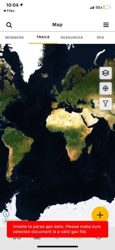
I have a friend that uses wikiloc. I just downloaded it. I saved a trail to my phone as a file but now I have no idea where on my phone it is. HahaYou need the right app for the job.
For Offline Offroad Orientation is maps.me nice , to see where you are, for the big picture. You have to download the map bevore you start.
For offline Road navigation is here the way to go. "Turn righ in the colorado road in 50m" is possible. You have to download the map bevore you start.
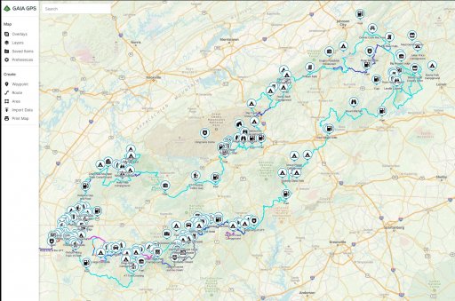
For offline offroad Navigation severall Apps are able to. Onx, GaiaGPS, Mapout, Locuspro, and severall more. You have to download the map bevore you start.
For offline Track-Navigation I like wikiloc. The "Member" Account allows to use it better offline - but it is usable too without. You have to download the Track bevore you start.
You probably will like my personal list of favorite travel-apps too.
All apps has their pro`s and cons.
trippin
Enthusiast II
40291
You seem to know your trail apps so I’m hoping I can get your help. I downloaded the wikiloc app and saved a trail as a file to my phone. When I open it i am brought to OB maps and I get this error.You need the right app for the job.
For Offline Offroad Orientation is maps.me nice , to see where you are, for the big picture. You have to download the map bevore you start.
For offline Road navigation is here the way to go. "Turn righ in the colorado road in 50m" is possible. You have to download the map bevore you start.
For offline offroad Navigation severall Apps are able to. Onx, GaiaGPS, Mapout, Locuspro, and severall more. You have to download the map bevore you start.
For offline Track-Navigation I like wikiloc. The "Member" Account allows to use it better offline - but it is usable too without. You have to download the Track bevore you start.
You probably will like my personal list of favorite travel-apps too.
All apps has their pro`s and cons.
trippin
Advocate III
20990
I responded to your other post.You seem to know your trail apps so I’m hoping I can get your help. I downloaded the wikiloc app and saved a trail as a file to my phone. When I open it i am brought to OB maps and I get this error.

Influencer I
27195