Trail Maps

  • HTML tutorial

Eric Haltom

Rank V
Launch Member

Advocate III

1,493
Mesa, Maricopa County, Arizona, United States
First Name
Haltom
Last Name
Family
Member #

6339

So I follow a popular mountain biking forum and one of the cool things that they have that I don't (or haven't) found here is a sort of trail forum that gives specific directions to get to the trail, the difficulty of the trail and a map of the trail. I think that's a great tool, but I think it could be improved if there were gpx files that could go with it. Looking around, we have the rally point, but I have failed to find a consolidated trails effort.

The idea I have in my head is that a member can submit a trail and another member (ranked member) can acknowledge or approve the trail. Then each member can filter the trails by state and difficulty.

I am a web developer, so if there is interest in this idea, I'd be happy to throw in a helping hand for the team!
 

Michael

Rank IX
Staff member
Founder 500
Member

Benefactor

15,584
Auburn, California, United States
First Name
Michael
Last Name
Murguia
Member #

0000

Ham/GMRS Callsign
KM6YSL
So I follow a popular mountain biking forum and one of the cool things that they have that I don't (or haven't) found here is a sort of trail forum that gives specific directions to get to the trail, the difficulty of the trail and a map of the trail. I think that's a great tool, but I think it could be improved if there were gpx files that could go with it. Looking around, we have the rally point, but I have failed to find a consolidated trails effort.

The idea I have in my head is that a member can submit a trail and another member (ranked member) can acknowledge or approve the trail. Then each member can filter the trails by state and difficulty.

I am a web developer, so if there is interest in this idea, I'd be happy to throw in a helping hand for the team!
What website are you referring to? I'd love to see what they have! Do you develop on WordPress? :)

M
 
  • Like
Reactions: fireyota30

Eric Haltom

Rank V
Launch Member

Advocate III

1,493
Mesa, Maricopa County, Arizona, United States
First Name
Haltom
Last Name
Family
Member #

6339

What website are you referring to? I'd love to see what they have! Do you develop on WordPress? :)

M
Hey Michael,
Here is the mountain bike website I was referring to. But I think there is sooo many oportunities to build upon this. http://trails.mtbr.com/

On this page they sort the trails by state. I think that you could use google maps (like the member map) to make this much more polished and user friendly, giving the opportunity to sort by zip, state city proximity. I actually worked for a bank a while back where I set up their branch location finder this way... it turned out great. It's too bad that bank was bought out, I'd have an example to show you what I am talking about.

I've worked on WP quite a bit in my web life. I currently have quite a few WP sites that I work on. My career is built on ASP.NET and PHP (which is what WP is built with). I am pretty familiar with all forms of development. One skill I think that would be pretty applicable in this project would be the google maps integration. I haven't done a whole bunch with gpx or klm files, but it's not even fun unless you're doing at least one new thing.
 

Laud

Rank VI
Launch Member

Influencer I

3,145
Southeast Arlington TX
First Name
Laud
Last Name
Maroney
Member #

7010

Ham/GMRS Callsign
-KG5QHC-
Service Branch
Air Force and Army
I do this within our local FB Group. I run them, then share with notes if applicable. I build in GE and share as KML. The hard part is maintaining the files, roads change and close and become impassable, leading to other issues. Yes, I have used the above mentioned site and built around it.
 

1Louder

Rank VI
Launch Member

Member II

4,187
AZ
First Name
Chris
Last Name
K
Member #

1437

Ham/GMRS Callsign
K1LDR
Not that I want to take ANYTHING away from Overland Bound but check out TrailsOffroad.com

I believe it has what you are looking for and there are currently 1000 trails available. It is all crowd sourced by TrailsOffroad writers and kept up-to-date! which is the most important piece.
 

browndirtcowboy

Rank I
Launch Member

Traveler I

271
Manteca, California
Member #

11606

I agree and will also add it would be nice to see more trails on the map. I see tons of members and meetups but trails are very few and far between. Acutally the main reason I joined was to find access to more trails ran by others to explore. Since Adventure is neccesary.
 

Lenneth T.B.O.

Rank I
Launch Member

Traveler I

233
Osage MN
Member #

13534

Can you not mark trails on the OB map? I thought that would be nice, and part of why I joined the group. I don't see much marked on the map. I feel it could be utilized way more by members to help other members get out. I am still figuring things out so let me know if I am wrong.
 

Crossoverlander

Rank I
Launch Member

Contributor I

233
Indianapolis, IN
First Name
Scott
Last Name
Manners
Member #

19457

What website are you referring to? I'd love to see what they have! Do you develop on WordPress? :)

M
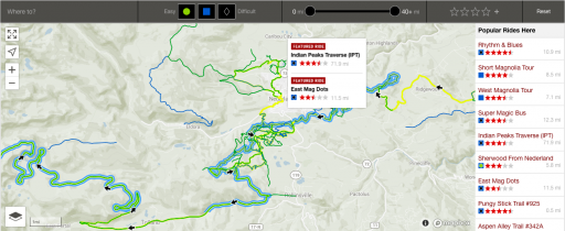
Hey Michael, new here and I just got my OB badge and number yesterday! I thought membership might unlock a map similar to the gpx trail maps on the REI MTB Project or AllTrails App (go to map section on either app). You simply zoom in and around the map and it shows the entire linework gpx of the route. These are mountain bike trails of course but I thought a similar map might be possible. Approved routes can get published on the map and you can zoom to your area and find stuff visually instead of searching and typing, showing the entire line of the route (not just a marker of the beginning). When you click on the line of the route, info pops up like length, trail terrain, gpx download link, difficulty etc...(Extreme difficulty rock crawler -- easy awd crossovers haha) This wouldn't have to be a map or app that tracks current location, it could just be a pre-planning type of map where you zoom in to explore your area, say "oh this route looks good", and then click the line of the trail and a gpx file download is also in the description. It would be super helpful, and more in-depth for members than a badge at the beginning of the trail, where we can't visually see the route. Hope this helps, just some positive criticism in growing OB! The pic below is the REI MTB Project App1_dswMMap3GdWEmuEPBsVESw.png
 
  • Like
Reactions: Ronin1057