The OFFICIAL Trans NJ Trail Thread

  • HTML tutorial

Xplorr313

Rank V
Founder 500
Launch Member

Enthusiast III

2,421
Burlington, NJ
First Name
Leon
Last Name
Jones
Member #

0313

Ham/GMRS Callsign
WQYY816
UPDATE:

I have created 4 new sub routes and deleted 1 old sub route. Here’s the details for each:

1: BUTTERMILK FALLS WINTER BYPASS, this short route will completely bypass the Buttermilk Falls section that is normally closed during the winter months. Usually Buttermilk Falls opens at the end of March or beginning of April.

2: HIGH POINT STATE PARK WINTER BYPASS, this short route will completely bypass the High Point State Park section that is normally closed during the winter months. Usually the park opens at the end of March or beginning of April.

3: SUNRISE MOUNTAIN WINTER BYPASS, this short route will completely bypass the Sunrise Mtn section that is normally closed during the winter months. Usually Sunrise Mtn opens at the end of March or beginning of April.

4: HB (Hacklebarney State Park Bridge) OUT DETOUR, this short route will take you on a very scenic detour around the bridge that is out and back to the TNJT.

THESE 4 ROUTES PLUS ANOTHER 5 ROUTES MUST MANUALLY BE STARTED AND STOPPED IF USING LEADNAV. YOU MUST REFER BACK TO THE TNJT MAIN ROUTE AND START THE ROUTE AGAIN AT THE END OF EACH BYPASS.

A few more changes made:

1: REMOVED SUNRISE MTN LOOP, I rerouted part of the TNJT main route to make the Sunrise Mtn more streamline and I actually made it part of the TNJT main route.

2: NEW TRAIL THROUGH STOKES STATE FOREST, this trail was open on 3-21-19 and it doesn’t look like it closes for winter either. It eliminated a lot of asphalt and made for a more scenic gravel part of the TNJT.

3: REMOVED A SMALL SECTION IN THE PINE BARRENS, removed a small section to make the route more streamline.

4: REMOVED A SMALL SECTION IN THE PINE BARRENS, removed the route that goes up Mount Rd to Mount and then right onto Washington Quakerbridge Rd. As stated in previous post, large trees are down and cause this part of the TNJT to not be traversed until further notice. Rerouted this section to continue straight on Washington Turnpike until you reach Ironpipe Rd.

New version of the TNJT is finished and will be uploaded to the original post soon. I will make a post when it’s loaded to the original post.

Thanks for your reports on the trail, they help keep the route flowing without issues.
 

NJ-Surveyor

Rank III
Launch Member

Enthusiast II

539
Gloucester County NJ
First Name
Mike
Last Name
Zimmerman
Member #

24731

Ham/GMRS Callsign
KD2SVY
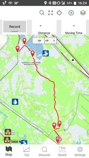
Cool. The Makepeace Lake area is a nice area with nothing difficult. Was all well with that section?
It's wasn't bad, there were a few sloppy sections. My 17 Tacoma OR didn't have any problems. I've seen the lake from the road, but didn't realize it was that big. Is the airport for small planes or remote control planes or both?
 
  • Like
Reactions: Xplorr313

Xplorr313

Rank V
Founder 500
Launch Member

Enthusiast III

2,421
Burlington, NJ
First Name
Leon
Last Name
Jones
Member #

0313

Ham/GMRS Callsign
WQYY816
It's wasn't bad, there were a few sloppy sections. My 17 Tacoma OR didn't have any problems. I've seen the lake from the road, but didn't realize it was that big. Is the airport for small planes or remote control planes or both?
The airport is for RC planes. I’ve never seen anything bigger than them there. That whole area is kinda cool to explore. If I remember correctly there’s an old barn and some buildings back behind the airport. Yeah the lake is pretty big, kinda shallow too in the summer months. I kayaked it once and I was literally bouncing off of tree stumps every couple feet lol
 

Adrian Peterson

Rank II
Launch Member

Contributor III

327
Danby, VT, USA
First Name
Adrian
Last Name
Peterson
Member #

14538

Hey All!

I drove a bit of the Trans NJ Trail last weekend and it was super easy. The only part that gave a challenge was a Jeep parked in the middle of a trail so I had to drive up a huge bank around him. LOL

Can anyone speak to the more difficult areas are? I’d like to shoot straight out to that area next time!

I ran the top 80 miles from High Point down if that helps narrow it down.

Thanks!
 

Xplorr313

Rank V
Founder 500
Launch Member

Enthusiast III

2,421
Burlington, NJ
First Name
Leon
Last Name
Jones
Member #

0313

Ham/GMRS Callsign
WQYY816
Hey All!

I drove a bit of the Trans NJ Trail last weekend and it was super easy. The only part that gave a challenge was a Jeep parked in the middle of a trail so I had to drive up a huge bank around him. LOL

Can anyone speak to the more difficult areas are? I’d like to shoot straight out to that area next time!

I ran the top 80 miles from High Point down if that helps narrow it down.

Thanks!
To be honest, if you want technical go to Rausch or go to Vermont. You’re not going to find anything technical on the TNJT. Once you get to the pine barrens then you will come across some water crossings and deep holes. Other than that, that’s all there is. You can thank the strict NJ laws against off roading for the easiness of the trail.
 

JerseyJohn

Rank I
Launch Member

Off-Road Ranger I

263
Easton,Pa
First Name
John
Last Name
Feckete
Ham/GMRS Callsign
N3AEI
If the new trail through Stokes is the one that come out at the end of the road for the falls and runs to Rt.560 that is Brook Rd and it is actually part of the Flatbrook Fish and Wildlife management area and is a public rd. My son and I were up there this past weekend and a State forest ranger was there so I asked just to be sure.

And according to the Ranger all STATE gates should have been opened on April 1, He said the National gates may take till April 15th
 
Last edited:

Xplorr313

Rank V
Founder 500
Launch Member

Enthusiast III

2,421
Burlington, NJ
First Name
Leon
Last Name
Jones
Member #

0313

Ham/GMRS Callsign
WQYY816
If the new trail through Stokes is the one that come out at the end of the road for the falls and runs to Rt.560 that is Brook Rd and it is actually part of the Flatbrook Fish and Wildlife management area and is a public rd. My son and I were up there this past weekend and a State forest ranger was there so I asked just to be sure.

And according to the Ranger all STATE gates should have been opened on April 1, He said the National gates may take till April 15th
Yeah part of the new route is Brook Rd. Thanks for the update on the gates.
 

bryantc3

Rank 0

Contributor I

Ran high point to a little past buttermilk yesterday. Looked like part of Bridge road off of Brooke (where there is a little bridge and fisherman) was still locked off (green gate).
 
Last edited:

JerseyJohn

Rank I
Launch Member

Off-Road Ranger I

263
Easton,Pa
First Name
John
Last Name
Feckete
Ham/GMRS Callsign
N3AEI
Ran high point to a little past buttermilk yesterday. Looked like part of Bridge road off of Brooke (where there is a little bridge and fisherman) was still locked off (green gate).

From the NJDEP Division of Fish and Wildlife page

The Three Bridges area on Mountain Road within the Flatbrook-Roy Wildlife Management Area is closed to vehicular traffic indefinitely. The decision to close the road was made based on concerns from Department of Transportation engineers regarding the structural integrity of the bridges. The area is accessible via foot and parking is along Mountain Road before the bridge closures. The public can also use alternate routes via Roy Bridge on Rt. 615 or Brook Road from Rt. 560. (View map)
 

bryantc3

Rank 0

Contributor I

From the NJDEP Division of Fish and Wildlife page

The Three Bridges area on Mountain Road within the Flatbrook-Roy Wildlife Management Area is closed to vehicular traffic indefinitely. The decision to close the road was made based on concerns from Department of Transportation engineers regarding the structural integrity of the bridges. The area is accessible via foot and parking is along Mountain Road before the bridge closures. The public can also use alternate routes via Roy Bridge on Rt. 615 or Brook Road from Rt. 560. (View map)
Ah, i was not aware of that. I had just been falling GAIA. Fortunately if you turn left instead of right, it all works out.

Brook Road off of tuttles was very nice though, it was definitely a change of pace from the scenic pavement drive heading down from high point.
 
  • Like
Reactions: JerseyJohn

Xplorr313

Rank V
Founder 500
Launch Member

Enthusiast III

2,421
Burlington, NJ
First Name
Leon
Last Name
Jones
Member #

0313

Ham/GMRS Callsign
WQYY816
From the NJDEP Division of Fish and Wildlife page

The Three Bridges area on Mountain Road within the Flatbrook-Roy Wildlife Management Area is closed to vehicular traffic indefinitely. The decision to close the road was made based on concerns from Department of Transportation engineers regarding the structural integrity of the bridges. The area is accessible via foot and parking is along Mountain Road before the bridge closures. The public can also use alternate routes via Roy Bridge on Rt. 615 or Brook Road from Rt. 560. (View map)
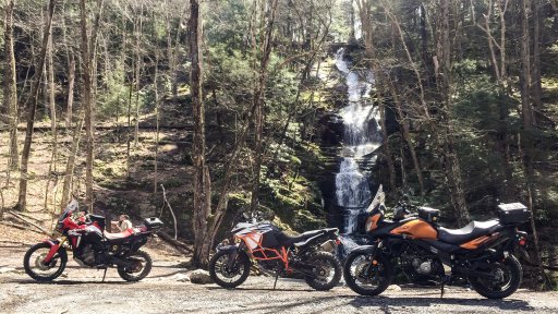
I really appreciate this info. I was just up there on the motorcycle yesterday but I didn’t go north of Brook Rd. I was heading north from Buttermilk Falls and turned right onto Brook Rd. I’ll make an edit to the route again and post it shortly. Thanks guys for all the updates!

508618B0-999C-493B-BB14-667CE144D956.jpeg
 
  • Like
Reactions: Nftyper

bryantc3

Rank 0

Contributor I

what time were you at buttermilk? i passed a solo guy on a dirtbike (or a street/dirt hybrid, don't really know them) but that was it. it was a nice ride through stokes and buttermilk. I think i'm gonna do the brook road down to maybe a little past hackle next weekend.
 

Xplorr313

Rank V
Founder 500
Launch Member

Enthusiast III

2,421
Burlington, NJ
First Name
Leon
Last Name
Jones
Member #

0313

Ham/GMRS Callsign
WQYY816
what time were you at buttermilk? i passed a solo guy on a dirtbike (or a street/dirt hybrid, don't really know them) but that was it. it was a nice ride through stokes and buttermilk. I think i'm gonna do the brook road down to maybe a little past hackle next weekend.
The exif of my Buttermilk Falls photo says we were there at 1:08pm on Saturday. Was the solo guy on a bright orange bike and looked more like a dirt bike? If so then that may be the guy that my group passed on Brook Rd. Remember that guy @MuckSavage ?
 

bryantc3

Rank 0

Contributor I

The exif of my Buttermilk Falls photo says we were there at 1:08pm on Saturday. Was the solo guy on a bright orange bike and looked more like a dirt bike? If so then that may be the guy that my group passed on Brook Rd. Remember that guy @MuckSavage ?
Ah we were there a bit later, around 5:45. I think the bike had some green accents. Rider was blacked out. I was in a white 2 door JK
 

MuckSavage

Rank V
Launch Member

Member III

2,268
South Jersey, NJ, USA
First Name
Tim
Last Name
McG
Member #

15570

@ xplorer313.....yeah, that guy was On it, ripping hard! It was shortly after my get-off/reality check that I was on basically Street Tread (Michelin Anakee 3’s) Kudo