Rothrock to Bald Eagle connection
- Thread starter DevilDodge
- Start date
-
Guest, UPDATE We went through the site migration runbook and completed all steps. We will need to complete the migration next week, but will leave the forums up for the weekend. A few days after maintenance, a major upgrade revision to the forum site will occur.


Starting to plan a trip. Debating the camping location.
So, all trips to Bald Eagle will begin in Rothrock(unless I have a specific reason to head to the northern section of BESF first)
I will begin as I have each trip on Colerain RD. Going to try to hit a few of the driveable trails in Rothrock and some of the roads I havent been on.
Still also need to see site 6 and 7.
Debating on staying at site 5 in Rothrock or staying in BESF. This decision may be made easy with the current pandemic as I am not sure if Rothrock is open to camping yet.
Most of my exploring will be in BESF as I have hit most all of this section of Rothrock. I do want to also make the connection to Sproul, Elk, and Moshannon. So I may head up that way aswell.
On this trip I will just be taking the truck. We have a plan to take our travel trailer in the next few weekends.
Not sure if I will just sleep in the truck or try out our new tent. Wife and son are to visit a friend and I may just go my self that weekend.
Either way. I can not wait to get into the Forest. Camping these past 2 weekends has been great...but I am ready for more wild life and less humans.
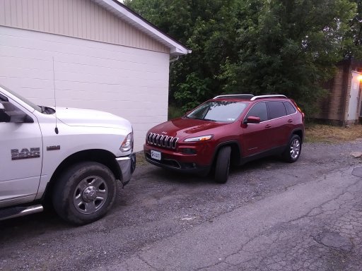

We are making the connection today with our new to us Jeep Cherokee.
Wife wanted to hit some Dollar Tree stores so I said...lets go through the forest.
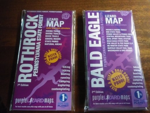
We started our adventure in Huntigdon and headed past Pulpit Rocks, a purple lizard on their Maps. Interesting to see. Another day would like to explore.
This was the maiden trip with the Purple Lizard Maps and the Jeep. We used them to plot the full course...headed by 2 of the Motorized camping sites. Site one was unoccupied...site 3 was occupied. hoping to hit more in BESF.
Then maps are very easy to read and are quite detailed. The awesome thing was the Navigation in the Jeep showed the roads we were on. That was very helpful.
I did forget about a road closure and we had to spend more time in the forest(or did I forget lol)
Wife was driving this trip...so I got to navigate and sight see.
We are finishing up at Quaker Steak and Lube and then heading to Bald Eagle.
Wife wanted to hit some Dollar Tree stores so I said...lets go through the forest.
We started our adventure in Huntigdon and headed past Pulpit Rocks, a purple lizard on their Maps. Interesting to see. Another day would like to explore.
This was the maiden trip with the Purple Lizard Maps and the Jeep. We used them to plot the full course...headed by 2 of the Motorized camping sites. Site one was unoccupied...site 3 was occupied. hoping to hit more in BESF.
Then maps are very easy to read and are quite detailed. The awesome thing was the Navigation in the Jeep showed the roads we were on. That was very helpful.
I did forget about a road closure and we had to spend more time in the forest(or did I forget lol)
Wife was driving this trip...so I got to navigate and sight see.
We are finishing up at Quaker Steak and Lube and then heading to Bald Eagle.
So, this is now my favorite way to get from where I live to the Susquehanna River. So relaxing to just meander from home to the larger cities through the forest.
Sure it takes a bit more time, but it sure beats blowing down the hiway at 70 and missing all the beauty.
The connection of the 2 forests can be made a few ways. Completely dependant on what you want to accomplish. You can do the whole thing with only crossing the hiway, or you can sneak out and back in going to see some of the cultures in the area.
The forest definitely has its busy spots, but for the long stretches of the trip, no other people.
You can do just about anything from driving to hiking. From mountain biking to dual sport motor cycles. From tubing to boating. And there is plenty of history and knowledge to learn.
Can not wait to get back.
Hopefully, weather permitting and a email to the office, my son and I will hopefully be spending the night in the forest.
We will definitely be exploring the forest. Both Rothrock and Bald Eagle.
Not sure if we will be taking the Jeep or the RAM.
We will be tent camping. Doing some hiking, but mostly exploring in the vehicle.
Right now I am thinking we will be staying at a motorized campsite. Probably in Rothrock, but may be Bald Eagle. If no motorized sites are available...we will probably make a stop at Poe Paddy.
As we have made this connection a few times, we will be putting emphasis on hitting trails we haven't been on.
If the weather isn't nice and we do make a reservation...i guess we will be taking the RAM sleeping in it.
I want to make the best experience for my son I can. It would be the first time my son camped in the wilderness....he is an old pro at campground camping though.
Gonna work some more on the plan after I make contact tomorrow with the office.
Can not wait to get out.

Enthusiast III
Looking forward to trying this connection out. I've been working on my jeep on and off for the last few months since COVID hit, so I have been out of commission. I need an alignment but once that's done I'll be ready to get back out on the trail. I also didn't know that the MABDR was open to 4x4, so that's awesome. I go to WV a lot so maybe I will follow it down one of these days.
Email is sent. Waiting for a reply and then can go onto a better plan.
My goals this trip is to test out our new tent and see how my son takes to know amenities or light.
1st in the explore list is to hit site #6 and #7. We haven't seen them yet. If we stay in Rothrock, this will be first on the list.
2nd is to enjoy the trails and area near were we camp. Try to learn about the wildlife and culture of human use there. Hope for more wildlife and less humans.
The biggest decision so far is Jeep or RAM. Wish I could drive both lol.
Got the campsite approval about 5 mins after I sent the request.
We are camping in Bald Eagle.
The campsite I settled on was a little bit further into BESF than I wanted. But it atleast was one we liked. Probably about 10 down the list of favorites.
We will be starting in Rothrock on Colerain RD as we have in the past.
There are a few things in Rothrock I want to explore. But, because of the distance to our campsite, we may have to skip them for another day.
We will be trying out our new tent. It is quite big for just me and my son...but ultimately my wife and daughter will join us on our trips.
Not sure what else i will bring. Guess our chairs, cooler and firewood.
We are taking our bikes and plan to hike.
Also going to do some geocache if they are in the area.
Can not wait to get out and enjoy
Got the permits printed out. Ready to go. Still got to get through today and tomorrow.
I hope the weather cooperates.
Good times
I hope the weather cooperates.
Good times
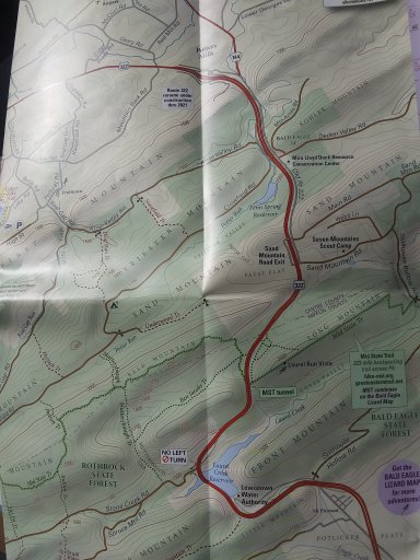
So an update on the connection. Route 322, which divides Rothrock and Bald Eagle has been under construction for some time.
The crossover we used the last time is now closed and you are rerouted along the highway.
As fate would have it...i needed the other road anyways. We were losing air out of my rear driver tire and I needed to get to an air pump.
I was able to complete the connection and hit a Sheetz for air.
So. If you have a vehicle with a smaller tank or didn't top off before Rothrock but wanted to before Bald Eagle...or snacks etc...you can leave Rothrock drive a short distance to Old Fort and have a choice between a Snappys or Sheetz.
As we have done a few times...State College is also right there and you could immerse yourself in the culture there and have many choices of fuel food and drink.
And now this other road is blocked as well. Hopefully they will open it soon. It seems they are doing road work. It will be very annoying if they permanently close it like the cross over
For anyone who cares about the connection here is the changes
Originally you just crossed over.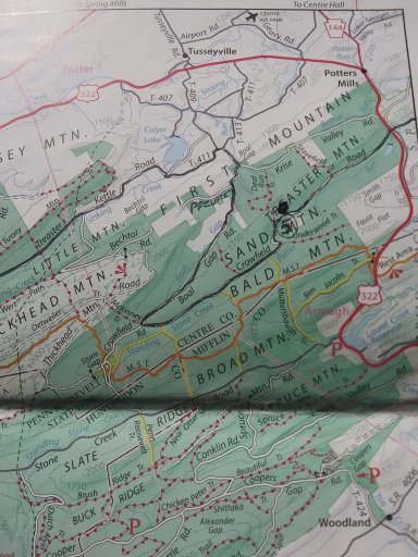
Then they did a run around.
This will be the end result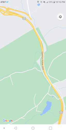
And this is the current situation. The red lines are the current road blocks and the green line is the route that is blocked. As well as up the other side to the red line.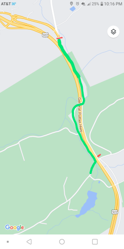
Any questions just ask and I will do my best to make it clearer.

Hey @DevilDodge, I am looking to do my own route after seeing your idea of traversing the forest. I planned my own route last night. I have no idea if I'm hitting ALL of your roads, but I imagine I am hitting quite a few.
I'm wondering how it went for you? Specifically the gated roads on the Lizard Map. Are those closed? I'm a bit confused how often they are closed or what they are limited to. I have backup roads if I run into any, but am wondering if I should expect them to be blocked.
I'm wondering how it went for you? Specifically the gated roads on the Lizard Map. Are those closed? I'm a bit confused how often they are closed or what they are limited to. I have backup roads if I run into any, but am wondering if I should expect them to be blocked.
The gated roads are closed. During hunting season some do open. They can be seen here...(click the link)
The best thing about the lizard maps is...if you see a road...and it isnt on the map...you should avoid it.
Any specific roads you have a question on, let me know.
Remember...the original crossing at 322 I posted about in the begining is no longer there. I am not sure if they finished construction yet or not. But it is easy to go around.
Good luck. Let me know how it goes @Sigs
Last edited:
Perfect, thank you. Shaver Creek Road is the one I'm looking at in Rothrock, not on your list, but goo to know I'll expect it closed. I did miss that 322 entrance closing. I was planning on taking that up to Bellefonte, but I see the other route too so that's easy enough.
Actually, one more question, any idea how long it took you to go through Rothrock? I'm leaving from Ebsenburg area, taking I99 up to Tyrone then doing this route to Bellefonte to meet some friends for dinner. I've done the I99 route hundreds of times at this point, but have no idea the kind of time these backroads will add. I plan on leaving plenty early, but some estimate would be great.
Actually, one more question, any idea how long it took you to go through Rothrock? I'm leaving from Ebsenburg area, taking I99 up to Tyrone then doing this route to Bellefonte to meet some friends for dinner. I've done the I99 route hundreds of times at this point, but have no idea the kind of time these backroads will add. I plan on leaving plenty early, but some estimate would be great.
Shared route
From To State Forest Picnic Area Rd to Bellefonte via Colerain Rd.
1 hr 40 min (43 mi)
1 hr 40 min in current traffic
Avoiding tolls
1. Head east on Colerain Rd/To State Forest Picnic Area Rd toward Brady Rd
2. Turn right onto Tram Rd
3. Arrive at location: Logan Township
4. Head northeast on Tram Rd toward Colerain Rd
5. Arrive at location: West Township
6. Head west on Tram Rd toward Harrys Valley Rd
7. Turn right onto Harrys Valley Rd
8. Arrive at location: Barree Township
9. Head east on Harrys Valley Rd toward PA-26 N
10. Turn right onto PA-26 S
11. Turn left onto Mt Rd
12. Turn left onto Forest Rd/Pine Swamp Rd
13. Arrive at location: Huntingdon County
14. Head northeast on Laurel Run Rd toward Bear Gap Rd
15. Slight left onto Bear Meadows Rd
16. Turn left onto Boal Ave
17. Take the I-99 N/US-220 N exit toward I-80/Bellefonte
18. Take exit 78B toward PA-150
19. Turn right onto Stoney Batter
20. Turn right onto W Bishop St
21. Turn left onto S Allegheny St
22. Arrive at location: Bellefonte
For the best route in current traffic visit To State Forest Picnic Area Rd to Bellefonte
Here is the no nonsense route I take to State College...tweaked to Bellefonte. @Sigs
This is starting at Colerain road and heading to 322 out Tussy Mountain.
Says 1 hr 40 mins. It will be more cause you will probably slow for a vista or 2.
I would say that is the bear minimum time.
Now. If you want to incorporate other roads...you could be there all day. This is the best I can do without knowing the route you want.
My avg speed in the forest is 11.5 mph. With some urgency I would bet that 20 mph would be achievable....avoiding 4x4 HC trails and sightseeing.
Hope this helps.
The 4x4 HC roads are out of the way from a direct route...but could easily be driven if you got the time. Let me know...i can give a route with them of you like.
Edit...i hate how this site does links. There is a link at the end of the directions to load the route on google maps.
Last edited:
