Places for Overlanding in/near Alabama

  • HTML tutorial

bamakojon

Rank III

Enthusiast III

503
Hueytown, AL, USA
First Name
Jonny
Last Name
Cochrane
Ham/GMRS Callsign
KI5DGM
Hello fellow southeasterners! Does anyone know of any good trails that are within a reasonable distance from the Birmingham, Alabama area? There's not a whole lot of public land around here (read: no BLM land), so I'm not really sure when I'm allowed to go and where I'm not. Any suggestions are very much welcome!
 
  • Like
Reactions: Neal A. Tew

Biker Eagle

Rank V
Launch Member

Member III

2,306
Chelsea, AL, USA
First Name
Steve
Last Name
Culbertson
Member #

9519

Service Branch
Former NOPD LEO
Talladega National Forest. 600-1 and 600-2 are the best but they're others. About 10 miles east of Sylacauga, off HWY 280.
There's also a trail at Little River Canyon out from Ft. Payne. And numerous roads in the Bankhead NF out from Double Springs. And there's an off road park at Hawks Pride Mtn in northwest Alabama. Another off road park west of Dodge City, just south of Cullman.
 

Neal A. Tew

US Rocky Mountain Local Expert
Mod Team
Member
Member

Member III

3,817
Pueblo West, CO
First Name
Neal
Last Name
Tew
Member #

12384

Ham/GMRS Callsign
N1TEW
Hello fellow southeasterners! Does anyone know of any good trails that are within a reasonable distance from the Birmingham, Alabama area? There's not a whole lot of public land around here (read: no BLM land), so I'm not really sure when I'm allowed to go and where I'm not. Any suggestions are very much welcome!

Just go ahead and make the move west like many of us have. You won't regret it! War Eagle, BTW. :D
 
  • Like
Reactions: Overlanding Lawyer

Cj13

Rank II
Member

Contributor II

327
Mount Olive, AL, USA
First Name
Chris
Last Name
Johnson
Member #

25839

I live just north of Birmingham in mount olive. There are tons of riding by my house and a bunch in pinson. Really depends on what type of riding you are looking for. Light trails to rock crawling. I'd be happy to show you some spots
 
  • Like
Reactions: Olyller

Tundracamper

Rank VI
Launch Member

Influencer I

3,068
Tuscaloosa, Alabama, USA
First Name
Steve
Last Name
Shepard
Member #

22670

Depends on what you want. For National Forests, there’s Talladega as mentioned above. There is the Oakmulgee District of Talladega down near Brent. Most roads in these two districts are mild gravel. However, the 600-1 and 600-2 mentioned above are pretty challenging and have some really nice scenic overlooks. Gaia has maps for all these roads.
 

Jackn123

Rank IV
Member

Advocate III

1,016
Birmingham, AL, USA
First Name
Jack
Last Name
Noble
Member #

25743

Hi all - picking this thread back up - I was thinking about exploring Bankhead this weekend with my family. I was doing some youtube research to see if I could find any footage from rides up there to get a sense of what it's like, but most of the footage looks like the roads are supper muddy and rutted out. I'm looking for more something a little less technical since I'll have my two young kids and will be riding solo and don't want to get stuck and have to deal with getting myself out with them in the car. Does anyone have any recommendations of specific areas that would be better to visit, or areas I should avoid? I gather there are some waterfalls up there, and I was hoping we could take a quick hike to one of them.
 

Tundracamper

Rank VI
Launch Member

Influencer I

3,068
Tuscaloosa, Alabama, USA
First Name
Steve
Last Name
Shepard
Member #

22670

Hi all - picking this thread back up - I was thinking about exploring Bankhead this weekend with my family. I was doing some youtube research to see if I could find any footage from rides up there to get a sense of what it's like, but most of the footage looks like the roads are supper muddy and rutted out. I'm looking for more something a little less technical since I'll have my two young kids and will be riding solo and don't want to get stuck and have to deal with getting myself out with them in the car. Does anyone have any recommendations of specific areas that would be better to visit, or areas I should avoid? I gather there are some waterfalls up there, and I was hoping we could take a quick hike to one of them.
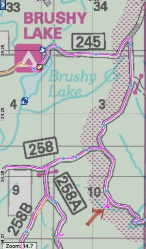
What part of Bankhead were you planning to visit? I don’t recall many, if any, roads being rutted out. In fact, I think most of the main FS roads were in pretty good shape last time I went. There are several horse/hunter camps you could stay at - or some place like Brushy Lake. There is a pretty little waterfall southeast of Brushy Lake. I don’t recall the name, but marked it with a red arrow in the map below. There is a pull off big enough for 2-3 cars and it’s a quick 5 minute hike down to the top of the falls. Follow the trail to the left to get down to the bottom.

C2CF81AB-7FDF-4584-A3D0-C3982CE52269.jpeg

Upper Caney Falls is also a pretty place that’s about a 20 minute hike from then road
 
  • Like
Reactions: Olyller

Jackn123

Rank IV
Member

Advocate III

1,016
Birmingham, AL, USA
First Name
Jack
Last Name
Noble
Member #

25743

What part of Bankhead were you planning to visit? I don’t recall many, if any, roads being rutted out. In fact, I think most of the main FS roads were in pretty good shape last time I went. There are several horse/hunter camps you could stay at - or some place like Brushy Lake. There is a pretty little waterfall southeast of Brushy Lake. I don’t recall the name, but marked it with a red arrow in the map below. There is a pull off big enough for 2-3 cars and it’s a quick 5 minute hike down to the top of the falls. Follow the trail to the left to get down to the bottom.

View attachment 166759

Upper Caney Falls is also a pretty place that’s about a 20 minute hike from then road
@Tundracamper thank you so much! This is incredibly helpful. I have never been to Bankhead, so I did not have a clear plan. I'm coming from Birmingham so I was focused more on the southern approach. Maybe Kinlock Falls and also I was thinking Upper Caney as well. Great to have some validation from you and the Brushy Lake area looks awesome. Thanks again!
 

Tundracamper

Rank VI
Launch Member

Influencer I

3,068
Tuscaloosa, Alabama, USA
First Name
Steve
Last Name
Shepard
Member #

22670

@Tundracamper thank you so much! This is incredibly helpful. I have never been to Bankhead, so I did not have a clear plan. I'm coming from Birmingham so I was focused more on the southern approach. Maybe Kinlock Falls and also I was thinking Upper Caney as well. Great to have some validation from you and the Brushy Lake area looks awesome. Thanks again!
Gaia has USFS maps that cover the area well. There are also hard copy maps, but they’re hard to find. Kinlock Falls are super easy to get to by car.

Holmes Chapel Falls is the one I referenced above - couldn’t remember name. Just south of there, off FS 255, is Capsey Creek crossing. I seem to recall that being a popular area with a trail, though I haven’t hiked it. Have fun!!
 

Jackn123

Rank IV
Member

Advocate III

1,016
Birmingham, AL, USA
First Name
Jack
Last Name
Noble
Member #

25743

Gaia has USFS maps that cover the area well. There are also hard copy maps, but they’re hard to find. Kinlock Falls are super easy to get to by car.

Holmes Chapel Falls is the one I referenced above - couldn’t remember name. Just south of there, off FS 255, is Capsey Creek crossing. I seem to recall that being a popular area with a trail, though I haven’t hiked it. Have fun!!
Thanks! I have been pouring over the different maps on Gaia. We may wind up going down to Talladega this weekend instead since it is a tad closer for us, but i'm planning my itenerary for when we head up there to Bankhead in the next few weeks. I just created a bunch of waypoints with the info you gave me last night. Much appreciated!
 

Jackn123

Rank IV
Member

Advocate III

1,016
Birmingham, AL, USA
First Name
Jack
Last Name
Noble
Member #

25743

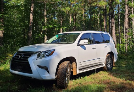
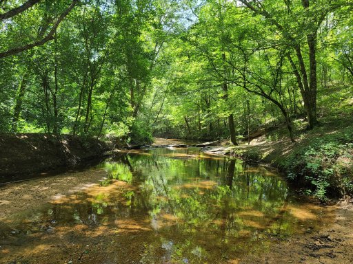
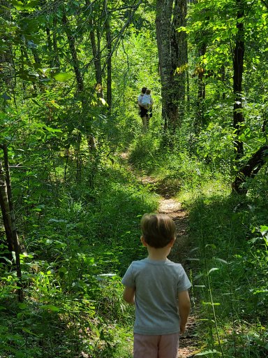
Just following up - we put some KO2s on our car on Saturday and then went down to TNF today and had a blast on some forest service roads. We had a great hike around Lake Virginia and then we found a great spot for a picnic by the Tallaseehatche Creek east of the bridge on the Wiregrass 601. Not a super challenging drive, but we enjoyed it.20200816_202747.jpg
20200816_111833.jpg
20200816_101131.jpg
 
Last edited:
  • Like
Reactions: Scott_3ba81a

Tundracamper

Rank VI
Launch Member

Influencer I

3,068
Tuscaloosa, Alabama, USA
First Name
Steve
Last Name
Shepard
Member #

22670

Just following up - we put some KO2s on our car on Saturday and then went down to TNF today and had a blast on some forest service roads. We had a great hike around Lake Virginia and then we found a great spot for a picnic by the Tallaseehatche Creek east of the bridge on the Wiregrass 601. Not a super challenging drive, but we enjoyed it.
Good info! Never been to those sites. Are they inside TNF? My map doesn’t cover Lake Virginia and that creek seems right on the border. I’m always looking for good camping spots, but wanna make sure I’m on public land.
 

Jackn123

Rank IV
Member

Advocate III

1,016
Birmingham, AL, USA
First Name
Jack
Last Name
Noble
Member #

25743

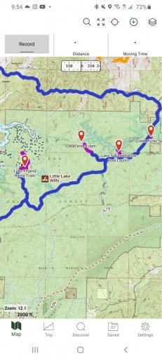
@Tundracamper Yeah the first part of the route is in the TNF, including Lake Virginia / Lake Willis / Lake Tallaseehatche - all of which are fed by the same stream where we had our picnic. See below - the green shading is the public land boundary. On the west side is a big network of hiking trails up towards Lake Howard - we only went a little way because our kids were wiped out, but you could hike through there for hours. Nice terrain / single track trail. I saw a couple of spots along the 601 where people had pulled off into some little clearings with fire rings, but I wasn't really on the lookout for camp spots. I remember there is a small site at the Tallaseehatche boat launch. The place we ate lunch is on the east side of the map. We parked above the bridge and walked down an embankment and went upstream a couple hundred feet and there was a nice flat (though sloped) surface. The north branch we took back to the highway was not in the public land and most of the trails on the map off of that road were gated. If we go back we will probably stay south and work our way over to the Bulls Gap / 600-1 area instead of going north.
 

Attachments

Last edited:

Tundracamper

Rank VI
Launch Member

Influencer I

3,068
Tuscaloosa, Alabama, USA
First Name
Steve
Last Name
Shepard
Member #

22670

@Tundracamper Yeah the first part of the route is in the TNF, including Lake Virginia / Lake Willis / Lake Tallaseehatche - all of which are fed by the same stream where we had our picnic. See below - the green shading is the public land boundary. On the west side is a big network of hiking trails up towards Lake Howard - we only went a little way because our kids were wiped out, but you could hike through there for hours. Nice terrain / single track trail. I saw a couple of spots along the 601 where people had pulled off into some little clearings with fire rings, but I wasn't really on the lookout for camp spots. I remember there is a small site at the Tallaseehatche boat launch. The place we ate lunch is on the east side of the map. We parked above the bridge and walked down an embankment and went upstream a couple hundred feet and there was a nice flat (though sloped) surface. The north branch we took back to the highway was not in the public land and most of the trails on the map off of that road were gated. If we go back we will probably stay south and work our way over to the Bulls Gap / 600-1 area instead of going north.
Quite helpful. Thanks! I searched Google maps for Lake Virginia and it came up over near Delta, just off HWY 9 on east side of forest - clearly not in the forest. I now see all this is in the same general area. I’ve been thru part of that area, but never stopped to explore. On my list now...
 

Tundracamper

Rank VI
Launch Member

Influencer I

3,068
Tuscaloosa, Alabama, USA
First Name
Steve
Last Name
Shepard
Member #

22670

@Tundracamper Yeah the first part of the route is in the TNF, including Lake Virginia / Lake Willis / Lake Tallaseehatche - all of which are fed by the same stream where we had our picnic. See below - the green shading is the public land boundary. On the west side is a big network of hiking trails up towards Lake Howard - we only went a little way because our kids were wiped out, but you could hike through there for hours. Nice terrain / single track trail. I saw a couple of spots along the 601 where people had pulled off into some little clearings with fire rings, but I wasn't really on the lookout for camp spots. I remember there is a small site at the Tallaseehatche boat launch. The place we ate lunch is on the east side of the map. We parked above the bridge and walked down an embankment and went upstream a couple hundred feet and there was a nice flat (though sloped) surface. The north branch we took back to the highway was not in the public land and most of the trails on the map off of that road were gated. If we go back we will probably stay south and work our way over to the Bulls Gap / 600-1 area instead of going north.
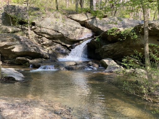
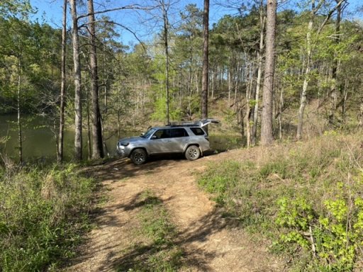
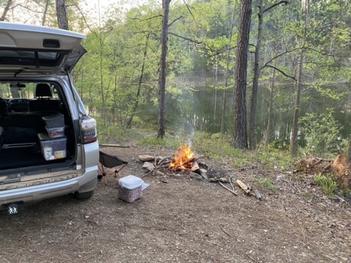
This has turned out to be quite amusing. It seems I actually camped at Lake Tallaseehatche just this past April. What confused me was that FS Road 601 was closed at the time, so I didn’t go past that lake. Great camping spot, except for the young folks that showed up at midnight to build a bonfire down near the boat ramp. I think they were avoiding the quarantine:). Very pretty area.

0D85AFF7-639C-4738-8C26-10BCC537AC69.jpeg9DC8DC54-61C0-4D6F-AE54-088CC0671233.jpegB99E9588-D241-4C03-912E-151CCE379967.jpeg
 

Tundracamper

Rank VI
Launch Member

Influencer I

3,068
Tuscaloosa, Alabama, USA
First Name
Steve
Last Name
Shepard
Member #

22670

Ha! Hilarious. That's the exact camp site I was referring to. Great pics.
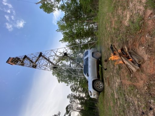
Have you been west over into the Oakmulgee District of TNF? There are some surprisingly scenic routes over there. Not as much water, except for large rivers (e.g. Cahaba). A few of the lookout towers have scenic views in the winter and make decent camping spots. I even stumbled across a neat water crossing on FS 743 near Cave Mountain.
DC79AF80-55B9-4BF2-82C9-7C0DF331971A.jpeg
 
  • Like
Reactions: Scott_3ba81a

Jackn123

Rank IV
Member

Advocate III

1,016
Birmingham, AL, USA
First Name
Jack
Last Name
Noble
Member #

25743

Sorry for the delay - life interrupted. No, I have not been to the Oakmulgee District before. I was just looking on Gaia though and it looks like there are tons of trails to explore. I just saved a loop out 743 and back on 742 for when we are able to get down there. What is that crossing like? Just a little brook or do you have to wade?
 
  • Like
Reactions: Tundracamper

Tundracamper

Rank VI
Launch Member

Influencer I

3,068
Tuscaloosa, Alabama, USA
First Name
Steve
Last Name
Shepard
Member #

22670

Sorry for the delay - life interrupted. No, I have not been to the Oakmulgee District before. I was just looking on Gaia though and it looks like there are tons of trails to explore. I just saved a loop out 743 and back on 742 for when we are able to get down there. What is that crossing like? Just a little brook or do you have to wade?
I’ve done 743, but not 742. The water crossing on 743 was probably a foot or so deep - though you may want to check before plowing thru with all this rain we’ve been having. I drive a stock 4Runner TRD OR and had no issues crossing. What you will find in Oakmulgee is that some roads are good gravel, some roads have muddy patches/water puddles, and others are not maintained at all. So, you may turn down a road and come up on a really big, deep, patch of mud. In that case, I just turn around. That’s only happened on like 2 or 3 occasions. Must mud puddles or patches are short and not too bad. I did notice this past weekend a lot of new road work in one area. So, they may have improved some roads. As you note, there are tons of options.

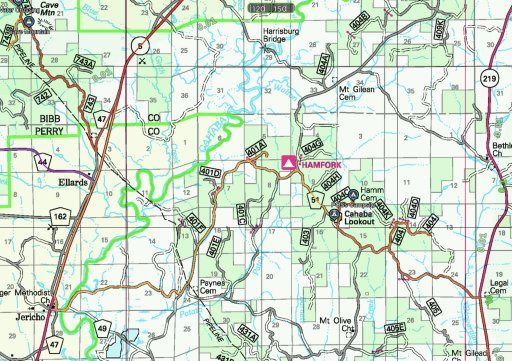
One of my favorite spots is Cahaba Lookout. Below is one of the routes I’ve taken from one of the 3 or 4 times I’ve been there. If you note Harrisburg Bridge on the top of that map, it crosses the Cahaba River. It is possible to drive under the bridge on the east side and get right up to the river. There is a little mud and sand, so I don’t know how drivable that is after one of these monsoons we’ve been having.

Further east (closer to Maplesville) is the Perry Mountain Lookout, which is probably my favorite spot in Oakmulgee. The view is probably not as nice as over at Cahaba Lookout. However, you can drive up to Perry Mtn Lookout and the road up is real fun. Nothing super hard, but it’s a short roller coaster. Plus, you can drive around the tower. I’ve camped at both spots. They are both worth the drive, in my opinion. It does look like they are clearing another hunter camp at Perry Mtn, so there may be some new work in that area.
5AC67484-E4CF-4A06-9AF2-E54D31CF244B.jpeg
 
Last edited: