Pine Creek Purple Lizard Map...

  • HTML tutorial

DevilDodge

Rank IV

Advocate I

1,135
Altoona, Pennsylvania, USA
First Name
David
Last Name
Spencer
I spent some time plotting a course with the Pine Creek map by purple lizard.

Anyone not familiar with the area the map covers...it is the area that includes the Pennsylvania Grand Canyon.

It is from Interstste 80 North to New York.

As I was looking at it I noticed quite a few areas if interest.

2 of our favorite state park campgrounds are here...Hyner Run and Little Pine.

I also noted alot of the signature purple lizards.

Looks like a few primitive campsites...but can not quite decipher if they are motorized or not. I do know that some are just for thru hikers.

Anyone got any seat time here?

Adding this to my list of trip planning.
 
  • Like
Reactions: Dusther210

Shokgoblr

Rank III
Launch Member

Off-Road Ranger I

676
PA, USA
First Name
Shok
Last Name
Goblr
Member #

25276

Ham/GMRS Callsign
Ihave1
I dont go leaf peeping, but this is where I do most of my hunting and rolling. I dont really understand why people go to rothrock and BSE when all this is here.
I know most of those roads very well especially closer to Leetonia.
 

OverlandZJ

Rank II

Enthusiast III

473
Bristol,Pa
First Name
John
Last Name
John
I spent some time plotting a course with the Pine Creek map by purple lizard.

Anyone not familiar with the area the map covers...it is the area that includes the Pennsylvania Grand Canyon.

It is from Interstste 80 North to New York.

As I was looking at it I noticed quite a few areas if interest.

2 of our favorite state park campgrounds are here...Hyner Run and Little Pine.

I also noted alot of the signature purple lizards.

Looks like a few primitive campsites...but can not quite decipher if they are motorized or not. I do know that some are just for thru hikers.

Anyone got any seat time here?

Adding this to my list of trip planning.

Take a look at the legend on back of that map, it ID's motorized, paddle/peddle, and primitive campsite's.

I have been camping in the area for years, not much there for primitive motorized anymore.. that i'v found or been turned onto by the area Rangers. I'd like to find a nice waterfront site somewhere in the Canyon area...

If you email the Ranger for permit you'll most likely deal with Robin, been there for as long as i can remember.. ask her for detailed input for what your looking for.

I found out just prior to Memorial Day weekend while up there that they dont allow trailers at some of the motorized primitive sites, even my small offroad pup. Just a heads up..

Colton Point SP is the main attraction in the area, i often run north through it to reach RT6. I'll share a secret.. theres a Farm Market for great fruit, produce or even food (sandwiches, occasional smoked 1/2 chicken breast/ribs) just across the bridge at 6 /287 just south of Wellsboro. Pag/Mar iirc..
 

OverlandZJ

Rank II

Enthusiast III

473
Bristol,Pa
First Name
John
Last Name
John
I dont go leaf peeping, but this is where I do most of my hunting and rolling. I dont really understand why people go to rothrock and BSE when all this is here.
I know most of those roads very well especially closer to Leetonia.

Used to camp at the clearing on Bear Run, they logged it, now it's full of weeds and dump piles. We used to drop grass seed up on the rise there.. would fit plenty of rigs for our larger get togethers.
 
  • Like
Reactions: Dusther210

Shokgoblr

Rank III
Launch Member

Off-Road Ranger I

676
PA, USA
First Name
Shok
Last Name
Goblr
Member #

25276

Ham/GMRS Callsign
Ihave1
Used to camp at the clearing on Bear Run, they logged it, now it's full of weeds and dump piles. We used to drop grass seed up on the rise there.. would fit plenty of rigs for our larger get togethers.
Yes, they are actively logging all of the areas up there. Makes for good hunting. But man I hate year 1-5 its so damn thick with cherry its hard to get through.
Have you run Reynolds Spring Trail yet?
 
  • Like
Reactions: Dusther210

OverlandZJ

Rank II

Enthusiast III

473
Bristol,Pa
First Name
John
Last Name
John
Yes, they are actively logging all of the areas up there. Makes for good hunting. But man I hate year 1-5 its so damn thick with cherry its hard to get through.
Have you run Reynolds Spring Trail yet?
It's been awhile, iirc it was closed for some time? I actually have camped just off the southern part at Gamble Run as it's trailer permittable. I'm looking to get back out there soon, i'll have to run it again and keep an eye out.
 

Larry Gaudreau

Rank II

Enthusiast I

404
Jacobstown, New Jersey
First Name
Larry
Last Name
Gaudreau
Member #

26247

We will be doing our annual fall foliage road trips soon.

This area is were we usually go. We like to head up 219 and come across Route 6.

Gonna be doing some staring at the map and plan a route.

Any one else excited to see the fall colors and doing any exploring here
Hi David, I'm new to the group. Looking forward to getting out on the trails and enjoying NATURE. I'm in central Jersey. My current rig is a 2001 Tahoe, Lots of room and a V8 with 320.000 miles but runs great. Just had to replace the heater hoses this morning, blew one out towing my sons boat to the Delaware river last Sunday. Easy fix.. thank goodness for VICE GRIPES .
 

DevilDodge

Rank IV

Advocate I

1,135
Altoona, Pennsylvania, USA
First Name
David
Last Name
Spencer
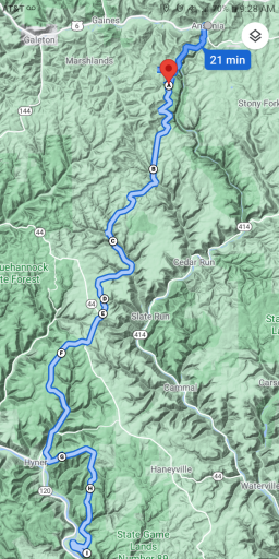
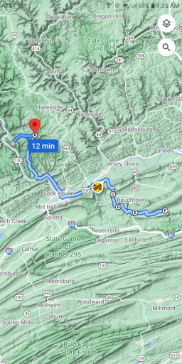
So I plotted a route from Ansonia Pa on the Purple Lizard Pine Creek Map through to the Bald Eagle Map.

This takes you from the Pennsylvania Grand Canyon past the 7 mile primitive camping site to Hyner View and down to Bald Eagle.

Purple Lizard Pine Creek to Bald Eagle 1st section

2 hr 35 min (60 mi)

Google Maps
Screenshot_20211013-092842.png

Purple Lizard Pine Creek to Bald Eagle. 2nd section

1 hr 33 min (43 mi)

https://maps.app.goo.gl/ToVDJ5x8nG5AR3Kp
9

Screenshot_20211013-093551.png
 

DevilDodge

Rank IV

Advocate I

1,135
Altoona, Pennsylvania, USA
First Name
David
Last Name
Spencer
I really dislike the way this forum does links....my only complaint.

The first route click on google maps above the first pic.

The second route click all the letters and numbers lol
 
Last edited:
  • Like
Reactions: Dusther210