OsmAnd and iOverlander

  • HTML tutorial

cug

Rank II

Enthusiast III

473
San Jose, CA, USA
First Name
Guido
Last Name
GNE
For a really long time I was looking for a way to combine proper offline navigation and iOverlander data in one way or another.

iOverlander2 at least gets to the point of offline data and maps, but there is no navigation, the app is phone only (I use an iPad). Maps.me doesn't properly import data, none of the other apps I tried is actually flexible enough to import data to the point I wanted.

GaiaGPS and OnX offroad are utterly useless for "normal navigation" and large area offline maps, so that left me with very few options.

My personaly solution now is: OsmAnd for full offline navigation with OpenStreetMaps and an insane amount of flexibiliy. It also imports GPX point of interest data as favorites if the files are properly done. So, what did I do:
  1. Got OsmAnd with a subscription so I can download more than the free areas, free would probably be okay for a lot of people though.
  2. Downloaded iOverlander CSV data (because it's the richest download format they have) for the countries I wanted (US and Canada for now).
  3. Wrote a data conversion tool to convert iOverlander CSV into OsmAnd GPX.
  4. Imported the data into OsmAnd and voila - it works. I can now see iOverlander POIs when navigating with OsmAnd.
This took me a while to sort out, due to iOverlander database issues and bugs in OsmAnd, but now, it works for my personal use case.

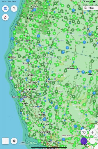
Here's how a massively zoomed out view looks like with POIs enabled:
IMG_0007.jpeg

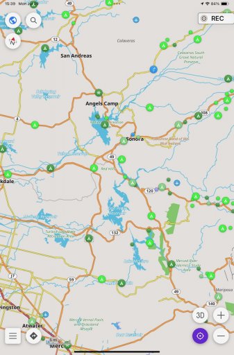
And a zoomed in view into a particular area:
IMG_0008.jpeg

I have to admit that OsmAnd is certainly not for everyone. It isn't the most stable app, it somestimes can't navigate the way I want to go or that would actually be correct and possible, and on a recent trip in Europe it wanted me to cross a large river at a point where there was no crossing ... ;-) So, still have to keep my brain activated when navigating.

Maybe this gives some folks ideas that it isn't all about Gaia, OnX, Google or Apple Maps etc. – all of these have issues to downlad LARGE areas for offline use (think countries or continents).
 

cug

Rank II

Enthusiast III

473
San Jose, CA, USA
First Name
Guido
Last Name
GNE
We've been using this combination (OsmAnd app and imported iOverlander data) on a trip now for three weeks and it has been working reasonably well.

Sure, there are some bugs in OsmAnd that are annoying and the user interface is rather ... ugly ... hmmm, I can think of more words, but I'll keep it polite. Let's just say that if I had delivered something like this in any of my last jobs as the user experience of a feature, I would have gotten fired on the spot ... But, and that's the important part, it is workable once you understand how it wants things done. I can use it, my wife can use it to a degree, but often isn't doing it the way OsmAnd wants things, so it involves quite a few choice words and some help from my side to make it work.

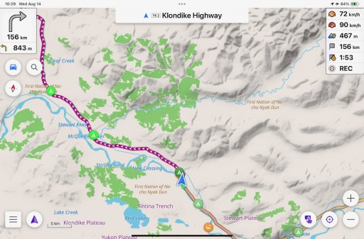
But anyways, here's a more realistic screenshot of the system in action:

IMG_0009.jpeg

It shows the route, and all imported iOverlander points of interest in colors I have pre-selected for the respective categories. We are approaching an established campground (dark green), there is a semi-official on the road that we passed (medium green) and some wild camping spots coming up (bright green). We do have some OsmAnd categories enabled as well and they show up along the route when it's zoomed in enough.

Overall, the system has done what I wanted/needed it to do. It generally works, it's 100% offline and all based on offline data. It shows very detailed maps, including terrain maps or elevation lines (if you download the respective maps). Navigation is sometimes a bit stupid and we generally double check what it tells us, but overall, I can say that it's the most funtional system I have tried.

In comparison:
  • Gaia offline navigation and general point to point navigation is worse than useless. Downloaded maps cover only small areas. So, utterly useless for traveling.
  • OnX Offroad – see Gaia. Just as bad, sometimes in the same, sometimes in different ways.
  • Garmin Tread – untested due to ridiculous hardware prices. The 8" tablet should be the price of the 5.5", the 5.5" is technology from 10 years ago, the 10" I haven't even looked at since it's too big and heavy. Plus, if it works similar to other Garmins I have used, it won't show you actual POIs on the navigation map, you have to actively search for them which is super inconvenient when you are traveling on a whim.
  • Apple Maps has been disgustingly bad in the regions we've been traveling. The data quality is laughable. Downloadable regions are a joke.
  • Google Maps is slightly better than Apple maps. Downloadable maps aren't great. And generally, it just doesn't work well offline when traveling.
With OsmAnd I was able to download maps (base, terrain, elevation lines) for California, Oregon, Washington, Montana, Idaho, Utah, Nevada, British Columbia, Alberta, Yukon, North West Territories, and Alaska and don't have to bother with tiny regions or getting the right update for the right map etc.

So far, so good. I can recommend the combination, although you have to have some pain tolerance regarding usability.
 
  • Like
Reactions: Stormwind

cug

Rank II

Enthusiast III

473
San Jose, CA, USA
First Name
Guido
Last Name
GNE
I’m currently on a trip, but in the next few days I can make the GitHub repo public.

Be aware: no tests of code or data integrity. This is a quick and dirty hack.
 
  • Like
Reactions: Stormwind

cug

Rank II

Enthusiast III

473
San Jose, CA, USA
First Name
Guido
Last Name
GNE
So, I've added minimal information on how to use the tool, but you still need to able to run Golang and be comfortable on the commandline.


This is super simple, has no input validation, no tests and might not even work with the lastest versions of the CSV download or OsmAnd. Please file issues accordingly. The way to get to an iOverlander CSV file is:
  1. Go to the iOverlander website
  2. Under "Find Places", select "Search for places"
  3. Select a country and the place types (check documentation which place types are already "wired up")
  4. Click Search
  5. Download the CSV file to be used with the converter
Good luck!
 
  • Like
Reactions: Stormwind

cug

Rank II

Enthusiast III

473
San Jose, CA, USA
First Name
Guido
Last Name
GNE
I've started doing some small things here and there, nothing big, some docs, some cleanup. Still traveling, so I'm not spending much time on it.
 

cug

Rank II

Enthusiast III

473
San Jose, CA, USA
First Name
Guido
Last Name
GNE
Thanks again! I'll look at it when I have a good block of time to work with it.
FYI: I made some changes, started input and output validation, and a lot of other cleanup. So, you might want to do a pull on the repository before you really start looking at the code. There should be zero change in the actual conversion, but the code is cleaner and it should be slightly more robust to bad input.