Steward II
- 10,598
- First Name
- Dave
- Last Name
- Addington
- Member #
-
10123
- Ham/GMRS Callsign
- KN6BKH
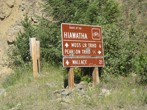
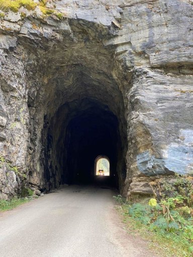
Wallace to Avery Idaho along the old Hiawatha tracks through tunnels and over bridges.

Steward II
10123

Steward II
10123


Enthusiast III
11737

Steward II
10123
The title was corrected, thanks! It’s the 10th, meet up on the 11th.Is it the 10th or 11th? It says 11th in the title but 10th in the rally point.

Steward II
10123

Explorer I

Steward II
10123

Explorer I

Steward II
10123
Really cool info! Thank youPosted from another site.
“The Route of the Hiawatha provides recreationists the unique ability to experience the Bitterroot Mountains through northern Idaho and western Montana from the relaxation of a gentle rail bed that extends roughly 15 miles through Shoshone County, Idaho. The right-of-way once belonged to the Milwaukee Road as an important main line to the West Coast. The route was the last transcontinental one completed during the early 20th century, linking Chicago with the Pacific Northwest. While it may have been the last, it was also the best engineered, featuring relatively easy grades, an overall shorter route, and a direct connection between Chicago and Seattle (unlike its rivals which had to interchange their trains at the Twin Cities to reach the Windy City). Unfortunately, an incompetent top management at the company brought the railroad to its knees, forcing it into bankruptcy and the eventual abandonment of its Pacific Coast Extension.
During its height, the Milwaukee Road was a massive system connecting a dozen states and not only reached Puget Sound but also stretched as far east as Louisville, Kentucky. Before the mega-merger movement, which created most of today’s seven large Class I railroads, the Milwaukee was the farthest reaching of its kind and had a main line network spanning more than 10,500 miles. The history of the company began humbly as the Milwaukee & Waukesha Railroad of 1847 to connect its namesake cities. After being renamed as the Milwaukee & Mississippi, it opened for service in 1850. After a receivership and two takeovers, the property was renamed the Milwaukee & St. Paul in 1867, and then again as the Chicago, Milwaukee & St. Paul (CM&StP) in 1874 when it opened a line to Chicago.
Throughout the rest of the 19th century, the CM&StP continued to expand throughout the Midwest, reaching Omaha, Kansas City, and the Twin Cities, as well as making deep inroads into Wisconsin, Illinois, Minnesota, Iowa, and South Dakota. By this time the company boasted a rail network of more than 5,000 miles, but officials felt that its status as a common “granger road” would not suffice. The name refers to the agricultural traffic it moved. To effectively compete with rivals Great Northern and Northern Pacific, they believed the CM&StP needed its own western extension reaching to Puget Sound. A study of the plan determined that building the 1,400 miles needed to connect Seattle would cost $45 million. Surveying for the project began in earnest in 1901; in 1905, the company board approved the construction, despite the cost being readjusted to $60 million. During 1906, work got under way when two primary contractors headed west from Mobridge, South Dakota, and east from Seattle. After just three years, the line was completed, thanks in part to new construction techniques and mechanized equipment. A golden spike ceremony was held at Garrison, Montana, on May 19, 1909.
The section that now makes up the Route of the Hiawatha was first surveyed during the fall of 1904 and completed two years later after officials decided the route should be built over St. Paul Pass along the Montana–Idaho border. Laying out this part of the main line through the rugged area was a staggering engineering feat. The railroad estimated that for every 1 mile of grade, at least 4.5 miles was actually surveyed and documented. Altogether, between Butte and St. Paul Pass, some 1,040 miles was surveyed; the actual line spanned those two points was only 230 miles. The primary contractor for the St. Paul Pass Tunnel was the Winston Brothers Company of Minneapolis, Minnesota, which also oversaw grading and other related work. The rest of the route from there to Avery, Idaho, was also handled by the Winston Brothers and another company. While today’s trail features eight of the line’s tunnels, none are more dramatic than St. Paul (also known as Taft Tunnel because of its nearness to the now-defunct town of Taft, Montana). The bore is 8,771 feet long (1.66 miles), 19 feet high, and nearly 15 feet wide, yet its relatively gentle grade (for a mountain railroad) is just 1.7% (a rise of 1.7 feet for every 100 feet traveled). Officially, the new route was opened on July 4, 1909, and is often regarded as the Pacific Coast, or Puget Sound Extension. A year later, passenger service began, and by 1911, the company was operating the transcontinental “Columbian” and “Olympian” (the latter of which was the road’s flagship run and renamed the “Olympian Hiawatha” in 1947).
To further expand upon the efficiency of its new route, officials decided to electrify the line over the five mountain ranges it crossed, including the Belts, Bitterroots, Cascades, Rockies, and Saddles. This project started in 1914 at Harlowton, Montana, and was soon completed to Avery, Idaho. Three years later, another section was completed between Othello, Washington, and Seattle. Finally during July 1927, the CM&StP completed electrification of its line into downtown Seattle at Union Station. Overall, it boasted an electrified network of 656 miles, although money issues precluded the “gap” between Avery and Othello from ever being completed. The cost of the railroad and succeeding electrification was staggering, $257 million; nearly six times the initial estimate of $45 million. The heavy debt forced the company into bankruptcy in 1925 from which it emerged in 1927 as the Chicago, Milwaukee, St. Paul & Pacific Railroad.
During the extension’s early years. traffic levels did not meet expectations, which eventually resulted in a second bankruptcy in 1945. Its outlook began to change during the 1950s and 1960s when freight volume began to grow, particularly that which originated from the Port of Seattle–Tacoma. After the 1970 Burlington Northern merger, the Milwaukee Road commanded most of the freight from this region because it featured the fastest main line through the Pacific Northwest (not to mention that its electrics vastly reduced operating costs). Unfortunately, the company could not be saved from its poor management team at the time, which wanted nothing more than to get out of the railroad business.
By the 1970s, the railroad was a subsidiary of the Chicago Milwaukee Corporation, a holding company that held business interests outside of railroads. It shut down the electrified operations in 1974 and neglected maintenance of the property, which resulted in increasingly slower train movements due to derailments on the extension. As things got worse, shippers began choosing alternatives to move their goods, such as rival Burlington Northern as well as Union Pacific and Southern Pacific. With its web of unprofitable branch lines in the Midwest and a decaying Pacific Extension, the company fell into bankruptcy a third time on December 19, 1977. In another shortsighted decision, management elected to abandon the entire railroad west of Terry, Montana, in 1979, a total of some 1,100 miles of track. They believed a core Midwestern system would be more profitable than its western lines. Sadly, this turned out not to be the case, and the company continued to slump until the remaining network was sold to the Soo Line in early 1985. Interestingly, following the extension’s abandonment, it was discovered that the corridor had actually still earned a profit even during its final days, despite the lack of maintenance and a bizarre double-entry of expenses on the company books. With the loss of the Milwaukee Road in the West, the Burlington Northern had a complete monopoly on freight traffic between Seattle and Chicago, a scenario which holds true to this day under successor BNSF Railway.
In May 1998, the Route of the Hiawatha opened to the public; three years later, the famed St. Paul Pass was also reopened on June 23, 2001. Today’s trail offers recreationists the chance to not only experience eight of the extension’s tunnels, but also cross seven of its magnificent trestles.
Given the remote nature of the trail, there are few nearby railroad attractions. You’ll find the Northern Pacific Depot Railroad Museum in Wallace, Idaho, and the Historical Museum at Fort Missoula, in Missoula, which features some train artifacts. Additionally, the Isaac Walton Inn is a few hours north in Essex, Montana, and is housed in the old Great Northern railroad motel.”

Steward II
10123

Explorer I

Explorer I
20162

Explorer I
20162

Contributor III

Contributor III
If you are looking for dispersed camping areas? There is a ton of that North of I90 out of Kingston or CDA / Fernan area above the lake. I am not sure if I will be going Saturday but if you end up needing help? I know all the roads and trails very well in that area. The route also only shows to Avery. I am not sure the plan free that but I see you are from Montana and you can head East towards Saint Regis or camp at Diamond Lake
