I think I’m a firm Sunday, but I may need to go earlier than later. Even if that’s alone haha. I downloaded those maps to Gaia. Should that be good enough to explore a bit? I’ve never been out there.
Nashville, Tennessee
- Thread starter tash
- Start date
-
Guest, UPDATE We went through the site migration runbook and completed all steps. We will need to complete the migration next week, but will leave the forums up for the weekend. A few days after maintenance, a major upgrade revision to the forum site will occur.
Yeah if you have the maps you'll be fine. There's really only one water crossing that ever gets "deep" and even then it's maybe only 15" or so... Nothing too crazy!I think I’m a firm Sunday, but I may need to go earlier than later. Even if that’s alone haha. I downloaded those maps to Gaia. Should that be good enough to explore a bit? I’ve never been out there.
OK great.
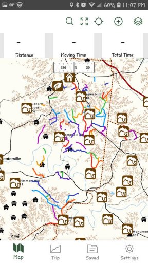
A little help needed here. I opened the KMZ file in GAIA on my iphone. When I click one of the trails, it gives me the option to view in the "Main Map" and I see a lot of colored roads. Are all of these colored roads dirt or gravel roads that are a part of the Dirt Devil? Never used this app before....Just want to make sure. Thanks in advance.
A little help needed here. I opened the KMZ file in GAIA on my iphone. When I click one of the trails, it gives me the option to view in the "Main Map" and I see a lot of colored roads. Are all of these colored roads dirt or gravel roads that are a part of the Dirt Devil? Never used this app before....Just want to make sure. Thanks in advance.
Not sure what set you downloaded but that sounds about right! I could send you a link to the file that I have that has the main trail on it if you'd like.OK great.
A little help needed here. I opened the KMZ file in GAIA on my iphone. When I click one of the trails, it gives me the option to view in the "Main Map" and I see a lot of colored roads. Are all of these colored roads dirt or gravel roads that are a part of the Dirt Devil? Never used this app before....Just want to make sure. Thanks in advance.
I think I might like to join on Sunday. Looks like this is just an afternoon run, yeah? What time?
https://www.overlandbound.com/forums/threads/please-share-southeast-downloadable-routes.11887/page-5
Post 83 is the map I downloaded
Post 83 is the map I downloaded
Sounds good. I was actually thinking about 10 or 11. The wife is wanting to go to the Christmas Tree lighting in downtown franklin and it starts at like 4:30 or something.I think I might like to join on Sunday. Looks like this is just an afternoon run, yeah? What time?
Try this one, this is mine. This will highlight just the main route. Let me know if this one works for you.https://www.overlandbound.com/forums/threads/please-share-southeast-downloadable-routes.11887/page-5
Post 83 is the map I downloaded
https://www.overlandbound.com/forums/index.php?threads/11733/
Are they the same map in different files? Either work with GAIA?
Edit. Got it. GPX opened up for me. Thanks man
What is the general consensus on accessibility? Are we going to run into private property and piss some people off or is this generally a pretty safe trip?
Edit. Got it. GPX opened up for me. Thanks man
What is the general consensus on accessibility? Are we going to run into private property and piss some people off or is this generally a pretty safe trip?
Last edited:
As long as you stay on the roads you shouldn't have any issues. They're all public roads.Are they the same map in different files? Either work with GAIA?
Edit. Got it. GPX opened up for me. Thanks man
What is the general consensus on accessibility? Are we going to run into private property and piss some people off or is this generally a pretty safe trip?

Advocate III
The file I posted does have different colored roads in it. And they are all dirt or gravel. Should be about 73 roads.OK great.
A little help needed here. I opened the KMZ file in GAIA on my iphone. When I click one of the trails, it gives me the option to view in the "Main Map" and I see a lot of colored roads. Are all of these colored roads dirt or gravel roads that are a part of the Dirt Devil? Never used this app before....Just want to make sure. Thanks in advance.

Advocate III
Yeah that’s what it looks like. The file from Tyler also shows it as a “loop” and they both overlap each other which is pretty cool.Should look like this in gaia if you tried to use my file...View attachment 77666
Not sure which day you all decided but I have the map for whoever wants it. I’m in south nashville and will be running a few errands today. I’m happy to lend it out to anyone in need.Dave_brez...do you have a good map of the dirt devil?
I’ve done about 80% of it and have it pretty well mapped on my gps.

Advocate III

Advocate II
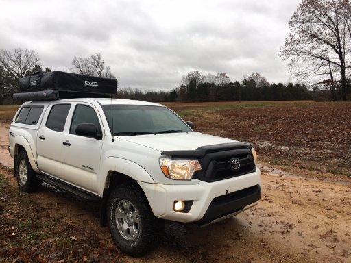
I’ll probably hit it later in the afternoon. The boys fell asleep late last night and didn’t want to wake up so early. Lol. Are thinking of hitting it again tomorrow after all this rain. I’d be down for tomorrow as wellI’m on it now...water crossings are ok so far todayView attachment 77681

Advocate III


