Why is it that not all roads on the USFS maps are on the respective MVUM maps? I know the obvious answers, whether they're private property, gated roads for FS use or other, etc. But when I'm using an MVUM in conjunction with a USFS map, it's not always clear to me where I can drive.
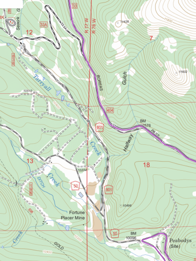
Example: Road 801 in this image is definitely a legally drivable road and there were signs saying that (my GPS track is in purple, the more highlighted black/white roads are the MVUM, all overlayed on a USFS basemap). So why isn't 801 shown on the MVUM?

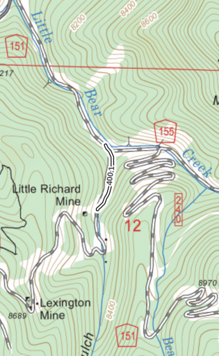
Another example: This one short segment of road (400.1) is on the MVUM, but nothing around it. If I were to stick to just the MVUM, how the heck do I get to this portion of road??

I bet this comes down to my understanding of land management (or lack thereof) and not fully understanding that all of the roads on the USFS are NOT USFS managed. It's still odd and confusing when I'm trying to put together routes and I'm trying to stay on legal, non-private roads.
Example: Road 801 in this image is definitely a legally drivable road and there were signs saying that (my GPS track is in purple, the more highlighted black/white roads are the MVUM, all overlayed on a USFS basemap). So why isn't 801 shown on the MVUM?
Another example: This one short segment of road (400.1) is on the MVUM, but nothing around it. If I were to stick to just the MVUM, how the heck do I get to this portion of road??

I bet this comes down to my understanding of land management (or lack thereof) and not fully understanding that all of the roads on the USFS are NOT USFS managed. It's still odd and confusing when I'm trying to put together routes and I'm trying to stay on legal, non-private roads.
Attachments
-
3.3 MB Views: 284


