

Trail: Mojave Road
Date traveled: January 2024
Location: California
Trail travel time: two to four days
Length: 150 miles
Difficulty: mild to moderate
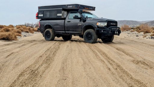
Vehicle: 2021 AEV Prospector & Four Wheel Camper
Modifications: none
Resources: none
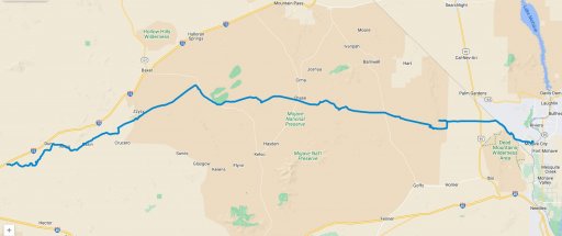
My most recent adventure was the 150-mile Mojave Road which passes east to west through southern California. I want to start by thanking the late Dennis Casebier for all of his work related to the re-discovery and layout of this historic trail. This trail has been used for centuries by American Indians to transport goods, by Spanish priests, early American's headed west, our US military, and adventurers like us. Dennis Casebier is also the author of the famous Mojave Road Guide.
This was my first campsite which also provided good protection from potential high winds rolling off the desert. Although the sleep that night was good I could tell my looking to the west that things were not going to be bright and sunny like they had been in Quartzsite. Since this was early in the adventure I thought long and hard about backing out and returning again at some point when the weather was nicer. I woke up and decided to continue my travel along this historic trail and convinced myself that I would minimize any chance of me becoming stuck and I had enough food and water to last several weeks so I would be just fine. Well, that's what I thought anyway...
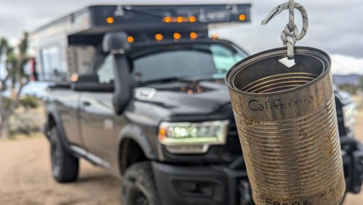
Ah, Penny Can Tree...a place to stop, pay your toll, make a wish, or in my case, say prayers, and snap a picture. I am not sure who began this strange ritual but there are several others along the way such as the mail box, frog shrine, and a ghost town named Zzyzx!
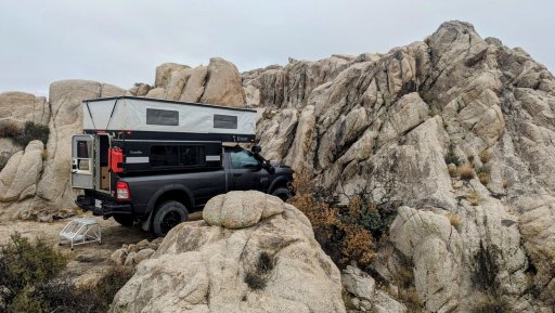
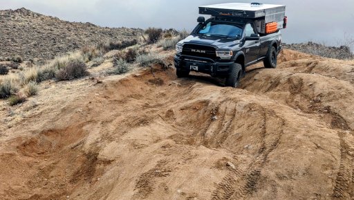
The hill dropping down into Watson Wash is a section along the trail where I spend more time teetering on two wheels, and sometimes three, but rarely all four. This mogul section was fun and although it does not appear to be anything challenging, I would suggest using a spotter, or as in my case, getting out and figuring out the safest path to the bottom of the hill. When you are all alone and your 8,700 pound truck is nose down and rolls to one side, you are fixated on there here and now and nothing else matters.
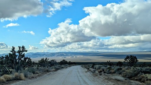
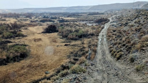
Guys, the views out here are breathtaking. If you look closely you will see the road stretching out to the horizon. A few miles down the road the view was even more beautiful - I looked to the left and watched the clouds bumping into a distant mountain range. I drove slowly and smiled so hard my cheeks hurt. This trip was majestic in so many places...
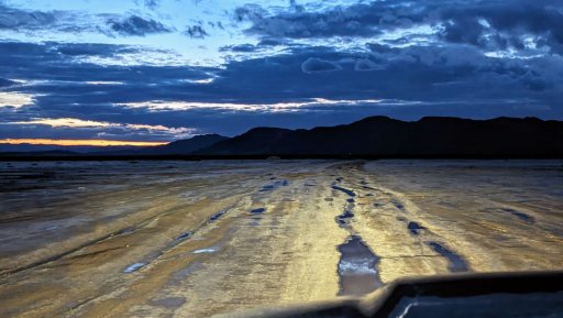
Here I am being the typical ramblinChet - rolling across Soda Dry Lake as the sun disappears, alone, on well used all-terrain tires, after it rained. Not. Very. Smart.
Let me back up and explain again why I always travel in two wheel drive - it's because I have a very good sense of the traction available and use this information for safety. If I lose control over my forward movement in two wheel drive I still have four wheel drive available which "should" provide me with the ability to exfiltrate myself. Although this is not beneficial 100% of the time I have discovered it works exceptionally well over the years. On the contrary, if I was in four wheel drive I most likely would have been able to proceed even farther, with a high probability of becoming very stuck, and then what?!?
For those who have traversed this dry lake before you know exactly what I am talking about when I say it was slick. For those up in the great white north, it's like sliding on wet ice that is not perfectly level, you just slooowly drift sideways. Despite my best efforts, I identified the traction issue early in two wheel drive and after shifting in four wheel drive, slowly began to back out. I was so happy I had reinstalled my backup camera and even turned on the LED rear flood lights on my camper so I was able to drive backwards and follow my previous tracks. Maybe if it was dryer, I had tires with much deeper tread, and I also was traveling with a few other rigs, I would have been successful. But this time I was successful in making the correct decision at the last possible moment, and removing myself from a potentially bad situation.
Since I was not able to cross Soda Dry Lake it took me maybe an additional hour to navigate up north, and find a way back down onto the Mojave Road. I make is a habit to pre-download all the GPX data for the surrounding area into Gaia so in the event that I have to create a bypass, and do not have cellular service, I still have a useful map displaying roads, topographical information, etc.
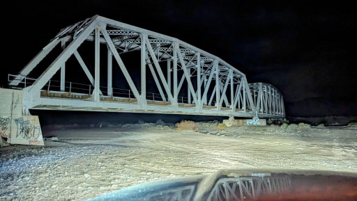
Once I was back on the trail I encountered some unusual situations. In this instance I would be driving into, and following, a wash, which included driving under, or alongside, several railroad bridges. I was only an hour or so away from camp so I felt the normal pressure to reach my goal but at the same time it was late, I had spent the full day on the trail, and the Mojave Road was different when compared to many of the trails I have encountered over the years. I guess the main differences I have noticed when traveling in the desert is that there are many parallel trails and it is difficult to select the proper one to travel on. There have been times where I was absolutely certain I was on the correct trail although it did not appear anyone else had used in in quite some time while at the same time there were multiple trails adjacent to the unused one I was on. And while some criss-crossed, others gradually pulled away and led off in other directions. And driving down a mostly dry, but sometimes wet and soggy river bed always feels a bit funny.
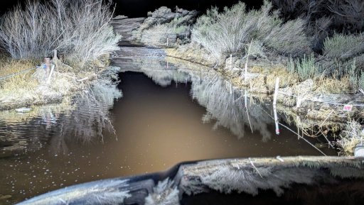
Here is a water crossing that was so close to camp it begged me to just hammer the accelerator and go. But I stepped out, surveyed the area, and after I was certain this was going to be a normal water crossing; placed my vehicle into low range, second gear, and kept my engine revs up as I crossed at 3-4 mph with an amazingly beautiful bow wave. Out the other side and so close to turning in for the night.
It rained throughout the night, and do you remember earlier when I convinced myself that I was an all weather type of guy with an all weather machine versus a fair weather fellow? As I woke up and prepared breakfast the rain came down even harder. I researched the last section of the trail and it showed me driving down through the center of the Mojave River and through places with names like nine-mile waterhole. Since I was just a few miles south of a major road I could navigate my way out to it, but I was so close...
So I saddled up, and headed back out in two wheel drive to continue along the trail while constantly testing the conditions. Actually, I was surprised to see how well everything was going and most of my time was spent in soft-fluffy sand with only a few wet and slippery areas. In this particular picture I had been traveling parallel to the railroad and was now dripping back down into the wash area - while it was still raining. For many with more experience in the area this may have been no big deal but for someone like me with limited experience in the desert, especially in wet conditions, it was another learning experience.
One of the most beautiful sights I saw near the end were other tire tracks in the wash I was following. It looked like two motorcycles had laid fresh tracks so it was very comforting to look ahead and see how the conditions treated them. Occasional animal tracks are seldom useful but here is a trick - if you want to sample an area to see how your vehicle may perform, do not walk across flatfooted but instead walk on your heels. Through the years I have experimented with all sorts of ways to estimate how deep a tire will sink when driving over a particular area and I have found that walking on your heels provides you with a measurement that includes a bit of a safety margin.
The Mojave Road was a wonderful adventure and I do hope you are able to explore it also. Compared to what I was able to view with my own eyes over the span of three days, these pictures have almost no value. By using words I struggle to even begin to capture just a small part of how good it felt to travel through time. Let me end by telling you that you really must begin to experience trail like this for yourself. And it would be even better if you were able to include others so years, or decades, from now, you can sit around a campfire and tell tall stories about nearly becoming entombed in a dry lake bed, or sleeping near a ghost town named Zzyzx, which according to some, "was the 'last word' in health and vitality."
Date traveled: January 2024
Location: California
Trail travel time: two to four days
Length: 150 miles
Difficulty: mild to moderate
Vehicle: 2021 AEV Prospector & Four Wheel Camper
Modifications: none
Resources: none
My most recent adventure was the 150-mile Mojave Road which passes east to west through southern California. I want to start by thanking the late Dennis Casebier for all of his work related to the re-discovery and layout of this historic trail. This trail has been used for centuries by American Indians to transport goods, by Spanish priests, early American's headed west, our US military, and adventurers like us. Dennis Casebier is also the author of the famous Mojave Road Guide.
Casebier points out that the road, while not a particularly tough 4-wheel drive trail, is a dangerous place. "You can die out there," he said. "And the people who want to go see the trail need to be equipped properly...you are alone and many, many miles from help when you're on that road."
This was my first campsite which also provided good protection from potential high winds rolling off the desert. Although the sleep that night was good I could tell my looking to the west that things were not going to be bright and sunny like they had been in Quartzsite. Since this was early in the adventure I thought long and hard about backing out and returning again at some point when the weather was nicer. I woke up and decided to continue my travel along this historic trail and convinced myself that I would minimize any chance of me becoming stuck and I had enough food and water to last several weeks so I would be just fine. Well, that's what I thought anyway...
Ah, Penny Can Tree...a place to stop, pay your toll, make a wish, or in my case, say prayers, and snap a picture. I am not sure who began this strange ritual but there are several others along the way such as the mail box, frog shrine, and a ghost town named Zzyzx!
The hill dropping down into Watson Wash is a section along the trail where I spend more time teetering on two wheels, and sometimes three, but rarely all four. This mogul section was fun and although it does not appear to be anything challenging, I would suggest using a spotter, or as in my case, getting out and figuring out the safest path to the bottom of the hill. When you are all alone and your 8,700 pound truck is nose down and rolls to one side, you are fixated on there here and now and nothing else matters.
Guys, the views out here are breathtaking. If you look closely you will see the road stretching out to the horizon. A few miles down the road the view was even more beautiful - I looked to the left and watched the clouds bumping into a distant mountain range. I drove slowly and smiled so hard my cheeks hurt. This trip was majestic in so many places...
Here I am being the typical ramblinChet - rolling across Soda Dry Lake as the sun disappears, alone, on well used all-terrain tires, after it rained. Not. Very. Smart.
Let me back up and explain again why I always travel in two wheel drive - it's because I have a very good sense of the traction available and use this information for safety. If I lose control over my forward movement in two wheel drive I still have four wheel drive available which "should" provide me with the ability to exfiltrate myself. Although this is not beneficial 100% of the time I have discovered it works exceptionally well over the years. On the contrary, if I was in four wheel drive I most likely would have been able to proceed even farther, with a high probability of becoming very stuck, and then what?!?
For those who have traversed this dry lake before you know exactly what I am talking about when I say it was slick. For those up in the great white north, it's like sliding on wet ice that is not perfectly level, you just slooowly drift sideways. Despite my best efforts, I identified the traction issue early in two wheel drive and after shifting in four wheel drive, slowly began to back out. I was so happy I had reinstalled my backup camera and even turned on the LED rear flood lights on my camper so I was able to drive backwards and follow my previous tracks. Maybe if it was dryer, I had tires with much deeper tread, and I also was traveling with a few other rigs, I would have been successful. But this time I was successful in making the correct decision at the last possible moment, and removing myself from a potentially bad situation.
Since I was not able to cross Soda Dry Lake it took me maybe an additional hour to navigate up north, and find a way back down onto the Mojave Road. I make is a habit to pre-download all the GPX data for the surrounding area into Gaia so in the event that I have to create a bypass, and do not have cellular service, I still have a useful map displaying roads, topographical information, etc.
Once I was back on the trail I encountered some unusual situations. In this instance I would be driving into, and following, a wash, which included driving under, or alongside, several railroad bridges. I was only an hour or so away from camp so I felt the normal pressure to reach my goal but at the same time it was late, I had spent the full day on the trail, and the Mojave Road was different when compared to many of the trails I have encountered over the years. I guess the main differences I have noticed when traveling in the desert is that there are many parallel trails and it is difficult to select the proper one to travel on. There have been times where I was absolutely certain I was on the correct trail although it did not appear anyone else had used in in quite some time while at the same time there were multiple trails adjacent to the unused one I was on. And while some criss-crossed, others gradually pulled away and led off in other directions. And driving down a mostly dry, but sometimes wet and soggy river bed always feels a bit funny.
Here is a water crossing that was so close to camp it begged me to just hammer the accelerator and go. But I stepped out, surveyed the area, and after I was certain this was going to be a normal water crossing; placed my vehicle into low range, second gear, and kept my engine revs up as I crossed at 3-4 mph with an amazingly beautiful bow wave. Out the other side and so close to turning in for the night.
It rained throughout the night, and do you remember earlier when I convinced myself that I was an all weather type of guy with an all weather machine versus a fair weather fellow? As I woke up and prepared breakfast the rain came down even harder. I researched the last section of the trail and it showed me driving down through the center of the Mojave River and through places with names like nine-mile waterhole. Since I was just a few miles south of a major road I could navigate my way out to it, but I was so close...
So I saddled up, and headed back out in two wheel drive to continue along the trail while constantly testing the conditions. Actually, I was surprised to see how well everything was going and most of my time was spent in soft-fluffy sand with only a few wet and slippery areas. In this particular picture I had been traveling parallel to the railroad and was now dripping back down into the wash area - while it was still raining. For many with more experience in the area this may have been no big deal but for someone like me with limited experience in the desert, especially in wet conditions, it was another learning experience.
One of the most beautiful sights I saw near the end were other tire tracks in the wash I was following. It looked like two motorcycles had laid fresh tracks so it was very comforting to look ahead and see how the conditions treated them. Occasional animal tracks are seldom useful but here is a trick - if you want to sample an area to see how your vehicle may perform, do not walk across flatfooted but instead walk on your heels. Through the years I have experimented with all sorts of ways to estimate how deep a tire will sink when driving over a particular area and I have found that walking on your heels provides you with a measurement that includes a bit of a safety margin.
The Mojave Road was a wonderful adventure and I do hope you are able to explore it also. Compared to what I was able to view with my own eyes over the span of three days, these pictures have almost no value. By using words I struggle to even begin to capture just a small part of how good it felt to travel through time. Let me end by telling you that you really must begin to experience trail like this for yourself. And it would be even better if you were able to include others so years, or decades, from now, you can sit around a campfire and tell tall stories about nearly becoming entombed in a dry lake bed, or sleeping near a ghost town named Zzyzx, which according to some, "was the 'last word' in health and vitality."
Last edited:


