Mojave Road trip - March 2017

  • HTML tutorial

Best weekend in March 2017 to go?

  • March 3, 4, 5

    Votes: 1 14.3%
  • March 10, 11, 12

    Votes: 1 14.3%
  • March 17, 18, 19

    Votes: 2 28.6%
  • March 24, 25, 26

    Votes: 3 42.9%
  • During the week would work better for me

    Votes: 0 0.0%

  • Total voters
    7
  • Poll closed .

fj80cruiserlife

Rank V
Founder 500
Launch Member

Enthusiast III

1,721
Daly City, California, USA
First Name
Jesse
Last Name
Garza
Member #

372

Watch this Post#1 for the occasional update as things progress or change.

Edit 2/7/2017: Check post #394 for some info. I will add other posts with key info for this trip, then put them together for the trail plan.

Edit 2/2/2017: So all, it's official, @Michael and @Corrie will be joining this trip, it just went from awesome to potentially epic.
Watch in the near future for updates to the end of this thread with some instructions, information and general motivation to make sure you know what you're getting into, either that or what you're gonna miss!
We've sorted out the details of the permit thing, we're getting two permits to cover the group. The vehicle limit will be 40 rigs, which is still huge but I think things will get pretty loose. We'll try to provide some direction, information and structure to make sure you have what you need, but this is an open trail ride in a huge area governed by both the National Park Service and the Bureau of Land Management, so....
Anyway. I'm stoked, motivated and can't wait for March!

Edit 1/22/2017: Added a video of the Pre-Run on MLK Weekend.

Edit 1/18/2017: I added a trip summary from our pre-run on MLK Weekend, read post #296/#297 if you're interested.


Added 11/14/16:
OK, this has been scheduled for the last weekend in March 2017. Let's move forward and plan this date. This should be an awesome trip.
If any of you have questions about what vehicle requirements are, if you wonder if your vehicle is appropriately equipped for this trip, post up!

Background: The Mojave Road is an historic road that runs basically from the Colorado River near the California/Arizona/Nevada border into the Mojave desert, terminating somewhere west of Baker, CA. More history to follow.

The general plan: March is a good time to visit, daytime temperatures are moderate, nighttime temps are tolerable if not chilly.

Rendezvous point #1 will be the Avi Casino just North of I-40 near the Colorado river. You have to go North about 3 miles from there to find the road (rendezvous #2). We'll start with that. This is an easy trail to jump out at various points if you need to make it shorter.

Fixed Dates: March 24 - 26, 2017 (Meet Friday Morning, hit the trail, finish Sunday afternoon)

Added 11/21/16
Headcount so far:

Tentatively committed:
@fj80toyman
@pabloquiros
@Judge
@Jeff_Tanner
@Comanche
@3T4RToymaker
@Truckerbizz
@Reichling +1 (?)
@mmnorthdirections
@dghcruising
@Reconnoiter
@DaveL (fixed, sorry Dave!)
@theick
@Scott
@Narbob
@Frank Cornejo (added 11/26/16)
@Mirek
@Edped (added 12/6/17)
@Zargon (added 12/6/17)
@Huerta32 (added 12/8/17)
@Raul B (moved on up!)
@ce4460
@Joel 11k
@gneargarder
@Michael1929
@O.Dfj
@picklejuice
@findmeoutside
@Michael (added 2/2/17)
@Stephen R Kennedy (added 2/2/17)
@Fakawi Tribe (added 11/26/16) --> moved up 2/4/17
@HMBxplore (added 1/25/17) --> moved up 2/4/17
@SAC-CA-Runner (added 2/6/17)

Tentative Maybe's:
@Max Hultman
@HammerheadFistpunch
@CoDawwg
@NetDep (added 11/26/16)
@Tom K
@Jaydub514
@Joey Treadwell
@Bluefox
@hallry
@Jkroberts
@Clint Hughes
@Houserw
@Saints&Sailors
@JayRock
@hidesertwheelin
@Clifford Bennett (added 1/29/17)
@Cayenne (added 2/5/17)


Edit: 1/12/17: If you are interested in this trip, let me know by posting in this thread and I'll add you to the "Tentative Maybe" list as a kind of waiting list because of the number of respondents!
Possibility of 30 or more rigs! Wow, this will be an undertaking for sure.
Not un-manageable, but it looks like we'll need a permit for sure, I'll follow up.
Really looking forward to this.

More info to come:
- Trail Comms
- Common meals / potluck?
- Sightseeing along the way - what to see?
- Other?
************************************** End 11/21/16 Edit

Vehicle requirements: Although I've heard tales of VW Vans and Pontiacs taking this trail, I would suggest at least stock 4WD as some of the trails can best be navigated with added traction. This is not a difficult trail but 3 days on dirt roads can be demanding. Small trailer friendly is my estimation as well.
Let's discuss more if you have questions about your particular vehicle and equipment.


...and here's March 2017.
View attachment 9969

Dan.
Dan it Jesse I might be off work this week please add me to the maybe list !
 
  • Like
Reactions: VCeXpedition

Kelly

US Full-time/Long Term Travel Member Rep
Launch Member

Traveler III

4,002
Rapid City, South Dakota, United States
First Name
Kelly
Last Name
Herrin
Member #

2032

Ham/GMRS Callsign
KFØDEX
I unfortunately have to bow out as the cost of doing some repairs to my truck wiped out my trip fund. Have a safe trip.

OB 1643
Caravan down and back with me, and I'll cover your gas. I see it as insurance. Bring your tow strap ;-)
 

Lifes2short4BS

Rank V
Launch Member

Influencer II

2,805
Half Moon Bay, Ca
First Name
Scotty
Last Name
N
Member #

1578

So, I've been nerding out on the Mojave Road Guide and Google Earth today. Based on just that, having never been on the Mojave road before.... It looks like Watson Wash might be able to accommodate our group the 1st night. It's about 43 miles in... Maybe Green Rock Mill the 2nd? Not sure if 40+ miles per day is a big push or not... I just don't see any other established camp sites that might fit us all... I also don't know how much leg stretching and potty breaks a group this big will need. Are we going to stop and see stuff like Picture canyon, or the lava tubes?
 

VCeXpedition

Rank V
Launch Member

Off-Road Ranger I

2,932
Pleasant View, UT, USA
First Name
Dan
Last Name
Rich
Member #

0582

Ham/GMRS Callsign
K6DHR
Here's installment #2 for the trip preparations.

Fuel and Water:
The trail is 3 days long, about 140 miles of dirt road. What mileage do you typically get in that scenario? Don't know? Then plan ahead. Do you know how much idling you'll be doing? Probably not, but more than normal. A typical rig can do this trail on a full tank. Problem is, if you've done some side trips, idled more than you thought you would, started the car to shower or to get warm, a full tank just might not be enough. I suggest you bring extra.

Camp etiquette with a large group:
1. We will be observing a 10PM sound curfew each night.
2. Be aware and considerate of others if you play music at your campsite. Please contain your music as much as possible.
3. Drinking/Drug use on the trail will not be tolerated, and you will be asked to leave the group.
4. Excessive drinking and drug use while camped overnight will not be tolerated, and you will be asked to leave the group.
5. Leave your campsite cleaner than you found it. Motorized enthusiasts, including overlanders are under severe scrutiny by some that would like to close all public land to vehicles, all they need is ammunition. We need to be good stewards of this land, Mojave is special. Let's take care of it.

An additional word about Campfires and firewood - Let's keep new fire rings from being created. If you have a portable fire pit, bring it so we don't have to start a new ring

There are a lot of other tips and comments available, here on this forum and other places on the web, please take a minute and look some up and raise your outdoor game and become a positive impact.

Trail etiquette to ensure safety and enjoyment while hitting the trail:
Available here in this forum and other places on the interwebs are good reads about how to behave on the trail. For the sake of simplicity (and brevity), can I just mention the one I think is the most important for a trail ride like this?
  • Keep the guy behind you in your mirror. That way, the group moves along and everyone is keeping an eye on everyone.
  • I will add more ideas and recommendations in the future to this topic!
Kids and Pets:
If you are bringing either, common sense dictates that they need to be closely watched. That is your job, and one of your most important jobs. Kids and dogs running around moving cars can end in disaster or at least hurt feelings. Keep track of your precious cargo at all times, be aware of where they are and what they're doing

Trail COMMS:
Communications on the trail is one key to creating a safe and also fun environment. There are many choices available. I'd like to create just a little direction to make things simple for whatever you choose.

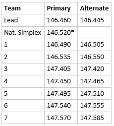
For effective communication between the various trail leaders, I'd like to request the frequencies 146.460 and 146.520 be kept clear. 146.460 can be used for quick and concise comms on the trail. 146.520 is officially the national simplex channel, but also used by Friends of the Mojave. If you would like to try and reach them, go to high power and give it a shot.

Here's an example of what I would suggest for frequencies for the teams:
(not sure how many teams there will be, just used 7 for now)

Suggested Simplex Comms for licensed Ham Operators
upload_2017-2-12_19-7-42.png
*also monitored by the NPS, use high power when trying to reach them (>5watts)

There are repeaters accessible in that area, I will do more research and find out which ones we can use if needed.

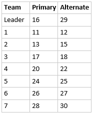
Suggested Comms using CB Radio
upload_2017-2-12_19-8-15.png

--> Looking for feedback on the frequencies and channels above, let me know if you spot any issues.

For FRS/GMRS
Please choose among each team which channel plus privacy PL to use for close-quarter comms in the team

HAM radio is my choice because of the availability of the frequencies as well as power output options. HAM requires a license to operate, but there are many available radios from Baofeng and it's cousins on the low-cost end, and brands like Yaesu, ICOM and Kenwood on the high-end.

Get what works for you, but CB and FRS/GMRS will not get the distance and clarity of Amateur Radio.

These are suggested channels and frequencies to simplify comms in a large group. If you all agree to use something else, as long as it doesn't overlap another team, that's great.

Here are a couple references for HAM radio information on these forums:
https://www.overlandbound.com/forums/threads/a-basic-overlanders-guide-to-mobile-radio-equipment-u-s-version.1918/
https://www.overlandbound.com/forums/threads/so-you-want-to-be-a-ham-us-edition.834/

Next up will be some information about how to help pay for the permits we need.
Trail plan including exit plans and interim Rendezvous Points.

Pretty soon we'll be looking for people to make a commitment so we can get a good count of how many of you will go.

...and finally, if you haven't filled out the SURVEY, please do so. Go to @Micheals post #331


Dan.
 

VCeXpedition

Rank V
Launch Member

Off-Road Ranger I

2,932
Pleasant View, UT, USA
First Name
Dan
Last Name
Rich
Member #

0582

Ham/GMRS Callsign
K6DHR
So, I've been nerding out on the Mojave Road Guide and Google Earth today. Based on just that, having never been on the Mojave road before.... It looks like Watson Wash might be able to accommodate our group the 1st night. It's about 43 miles in... Maybe Green Rock Mill the 2nd? Not sure if 40+ miles per day is a big push or not... I just don't see any other established camp sites that might fit us all... I also don't know how much leg stretching and potty breaks a group this big will need. Are we going to stop and see stuff like Picture canyon, or the lava tubes?
Yep, I do the same thing. I was there in the middle of January though, I'm not sure if Watson Wash is not too far to go on the first day. There is a detour around Fort Piute that will add some time if that road is still closed. Check out the corral on the other side of the mountain from Fort Piute.
There are a lot of options for a lot of rigs around there, but near the corral they might be a little dispersed, good or bad.

And potty breaks are something folks need to get dialed in too.

Green Rock Mill is a good place for the last night if we can make it that far on day 2, plenty of room for a lot of rigs, but pretty barren. It's the last place to camp before heading across Soda Dry Lake and a good place to make a decision whether or not to make the crossing or do a go-a-round plan.

Dan.
 
  • Like
Reactions: Narbob

RobRed

Rank V
Launch Member

Enthusiast III

@fj80toyman / @HMBxplore

40 miles a day is a big push unless you dont want to explore. Camp sites for this large of a group are tough to come by. Watson Wash my not be allowed - at least a section of and it's 50 miles in plus the detour... so 60 miles. A small group could make more miles in a day but you are driving

Based on the Mojave Road Guide mile markers:

41 miles Day 1
Night 1 - mile Marker 31.4 / Piute Corral you can get 40 there and along the road with some careful placement. The corral itself has two rock fire rings. This is a long haul due to the closed section detour or 14 miles. I'm assuming that you will visit Fort Piute in the mileage calculation.

46 Miles Day 2
Night 2 - Mojave Camp near mile marker 67.5. Multiple established fire rings. You'll get 40 in but it may be tight and its popular.

30 Miles Day 3
Night 3 - not a lot of choices for the size.... Green Rock Mill itself could take 40, its not very level... the lower section could but it's not established. Just before mile marker 95.6 there is a trail into Little Cowhole Mountain that could work as it's off the beaten path but I haven't been up there so cant say.

25 Miles Day 4 if exiting at Afton Canyon

If you are staggering groups you should get an early start each day to account for speed differences. Sunset will be 7.20p this time of year. I would recommend an hour by hour sheet. I use them to great effect on my trips - it keeps people happy.

Here is a blog post regarding Ham radio newbies. Most folks are getting the license call sign in 4-7 days post test. http://tlcfaq.com/main/2016/12/why-ham-radio/
 
Last edited:
  • Like
Reactions: dghcruising

RobRed

Rank V
Launch Member

Enthusiast III

It just hit me that you are doing 3 days 2 nights so my camping suggestion above won't work for you.

Edit++++

If you dont do the detour you could make it to lower Carruthers which is north of mile maker 45.9 There is a couple of areas that are capable of taking the 40 just a mile up the road.
 
Last edited:

Scott

Rank VI
Launch Member

Influencer II

3,921
Bates City, MO, USA
First Name
Scott
Last Name
Heiser
Member #

2486

Just let me know when you want payment for permits. I'm in for whatever needs to happen. And as discussed I am also willing to be tail gunner for one of the groups.
 
  • Like
Reactions: Zargon

Lifes2short4BS

Rank V
Launch Member

Influencer II

2,805
Half Moon Bay, Ca
First Name
Scotty
Last Name
N
Member #

1578

It just hit me that you are doing 3 days 2 nights so my camping suggestion above won't work for you.

Edit++++

If you dont do the detour you could make it to lower Carruthers which is north of mile maker 45.9 There is a couple of areas that are capable of taking the 40 just a mile up the road.
I'm taking an extra day off on each end. If I need to camp/get a room the last night I will, But It's looking like we need to do roughly 50 miles per day... I'm just a nOOb that tends to obsess over things of this nature. I'm just along for the adventure.
With the staggered departure times, we might end up with staggered camp sites. If we can all get together each night, it would make for some epic video shots from the drones, and I think @Michael videos everything lol
 
  • Like
Reactions: Zargon

Lifes2short4BS

Rank V
Launch Member

Influencer II

2,805
Half Moon Bay, Ca
First Name
Scotty
Last Name
N
Member #

1578

Yep, I do the same thing. I was there in the middle of January though, I'm not sure if Watson Wash is not too far to go on the first day. There is a detour around Fort Piute that will add some time if that road is still closed. Check out the corral on the other side of the mountain from Fort Piute.
There are a lot of options for a lot of rigs around there, but near the corral they might be a little dispersed, good or bad.

And potty breaks are something folks need to get dialed in too.

Green Rock Mill is a good place for the last night if we can make it that far on day 2, plenty of room for a lot of rigs, but pretty barren. It's the last place to camp before heading across Soda Dry Lake and a good place to make a decision whether or not to make the crossing or do a go-a-round plan.

Dan.
If i'm looking at the right spot.. that's a half mile long crescent. Looks like it could fit us all....
 

RobRed

Rank V
Launch Member

Enthusiast III

I'm taking an extra day off on each end. If I need to camp/get a room the last night I will, But It's looking like we need to do roughly 50 miles per day... I'm just a nOOb that tends to obsess over things of this nature. I'm just along for the adventure.
With the staggered departure times, we might end up with staggered camp sites. If we can all get together each night, it would make for some epic video shots from the drones, and I think @Michael videos everything lol

I'm sure you will have great time.

I've led about a dozen large trips (up to 20) ... I'm not even on this trip though i may be in that area, just wanted to share some knowledge to help.
 

VCeXpedition

Rank V
Launch Member

Off-Road Ranger I

2,932
Pleasant View, UT, USA
First Name
Dan
Last Name
Rich
Member #

0582

Ham/GMRS Callsign
K6DHR
I'm in have the days off and rig is ready.
Im in if there is still room. this will be my first trip with the group
I listed both of you guys on the Tentative list as this is sort of the waitlist.
There probably won't be any issue, just showing the date you opted in, no worries.


Dan.
 
  • Like
Reactions: Zargon

Tom K

Rank V
Launch Member

Off-Road Ranger I

2,041
Zürich, Switzerland
Member #

2060

Ham/GMRS Callsign
KM6JHR
You can move me up to committed if/when there's space. I'm going to install a diff breather this weekend and I'm working on the other stuff like a chemtoilet and spare fuel. Also have been studying my HAM questions.

Sent from my Pixel using Tapatalk
 
  • Like
Reactions: VCeXpedition

Zargon

Rank V
Launch Member

Pathfinder I

I will be in the CB crowd for now. I might go for the HAM license this summer
I also am going to be probably falling into the CB crowd. I wanted to get my HAM License before the trip, but I just don't have the time by the looks of things. Is there any reason why we shouldn't be using MUR's frequencies? Correct me if I am wrong, but I believe you don't need any license to transmit, and you should get all the benefits of HAM.