Max Patch/Harmon Den WMA

  • HTML tutorial

HeelsFan72

Rank IV
Launch Member

Enthusiast II

979
Chapel Hill NC
First Name
Tanner
Last Name
Hedrick
Member #

21506

Has anyone been up to Max Patch or been around Harmon Den Wildlife Management Area recently? I never made it out to Hurricane Creek before it closed, but it looks like there are other options to drive up to Max Patch such as Cold Springs Creek and/or Max Patch Rd (and possibly others). Curious if anyone has driven any of these roads recently-- any info on the condition, is it worth the drive, campsites along the route, etc.

Thanks in advance!
 

Sasquatch SC

Rank VI
Launch Member

Member III

3,782
Jefferson County, Colorado, United States
First Name
Trey
Last Name
Hayes
Member #

17253

Has anyone been up to Max Patch or been around Harmon Den Wildlife Management Area recently? I never made it out to Hurricane Creek before it closed, but it looks like there are other options to drive up to Max Patch such as Cold Springs Creek and/or Max Patch Rd (and possibly others). Curious if anyone has driven any of these roads recently-- any info on the condition, is it worth the drive, campsites along the route, etc.

Thanks in advance!
Hitting the Harmon Den to Max Patch is super wide, well maintained and should present no obstacle to nearly any vehicle. I'm going up that way tomorrow, but I'm going to Buzzard Roost and exploring some of the side routes.
 
  • Like
Reactions: HeelsFan72

Sasquatch SC

Rank VI
Launch Member

Member III

3,782
Jefferson County, Colorado, United States
First Name
Trey
Last Name
Hayes
Member #

17253

Hitting the Harmon Den to Max Patch is super wide, well maintained and should present no obstacle to nearly any vehicle. I'm going up that way tomorrow, but I'm going to Buzzard Roost and exploring some of the side routes.
So the side of Harmon's Den going up to Max Patch is really tame as well as Cold Springs Creek. HOWEVER, if you go the opposite direction from the Harmon's Den exit towards Buzzard Roost things get really rowdy, and REALLY, REALLY, REALLY fun. It was pretty difficult in the super muddy, slippery, semi-frozen condition but we had an absolute blast.
 

HeelsFan72

Rank IV
Launch Member

Enthusiast II

979
Chapel Hill NC
First Name
Tanner
Last Name
Hedrick
Member #

21506

So the side of Harmon's Den going up to Max Patch is really tame as well as Cold Springs Creek. HOWEVER, if you go the opposite direction from the Harmon's Den exit towards Buzzard Roost things get really rowdy, and REALLY, REALLY, REALLY fun. It was pretty difficult in the super muddy, slippery, semi-frozen condition but we had an absolute blast.
That's awesome-- Buzzard Roost has been on my to-do list! When you say "really rowdy" is it something you wouldn't tackle in a stock ride 4Runner (~10 inches of clearance) with very tame AT tires? Glad you had fun!
 

Sasquatch SC

Rank VI
Launch Member

Member III

3,782
Jefferson County, Colorado, United States
First Name
Trey
Last Name
Hayes
Member #

17253

That's awesome-- Buzzard Roost has been on my to-do list! When you say "really rowdy" is it something you wouldn't tackle in a stock ride 4Runner (~10 inches of clearance) with very tame AT tires? Glad you had fun!
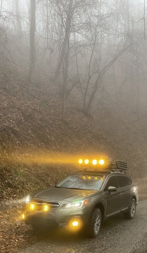
Getting to the Roost was nothing, easy two-track. We took an alternate trail from there that was pretty rutted out and included a creek crossing that had some big boulders in it. It was pretty hairy going down and tricky to get across the creek without getting high center. I did it in my lifted Outback with a Jeep WK2, Jeep JLU, and a Silverado all in tow letting me be the guinea pig. I wouldn't want to try it solo. Some of those ruts were crazy deep, and the creek crossing was a little intense too. Basically had to do a 3-point turn to get around a particularly big boulder in the middle.
 
  • Like
Reactions: TerryD

TerryD

Rank VI
Launch Member

Member III

3,402
Covington, Virginia, USA
First Name
Terry
Last Name
R
Member #

3710

Ham/GMRS Callsign
KT4OZ
Getting to the Roost was nothing, easy two-track. We took an alternate trail from there that was pretty rutted out and included a creek crossing that had some big boulders in it. It was pretty hairy going down and tricky to get across the creek without getting high center. I did it in my lifted Outback with a Jeep WK2, Jeep JLU, and a Silverado all in tow letting me be the guinea pig. I wouldn't want to try it solo. Some of those ruts were crazy deep, and the creek crossing was a little intense too. Basically had to do a 3-point turn to get around a particularly big boulder in the middle.
I'll have to get up with you this summer and go check it out! I've been wanting to get down that way for a while but haven't made time for it.
 
  • Like
Reactions: Sasquatch SC

Sasquatch SC

Rank VI
Launch Member

Member III

3,782
Jefferson County, Colorado, United States
First Name
Trey
Last Name
Hayes
Member #

17253

I'll have to get up with you this summer and go check it out! I've been wanting to get down that way for a while but haven't made time for it.
Any time bud. I'm always exploring. I'm actually looking into heading back to this same area this weekend to explore some of the tracks north of Max Patch. Before I got Gaia, I got turned around up there after doing Hurricane Creek last spring and there are a lot of cool little roads that I haven't heard anything about.
 
  • Like
Reactions: TerryD

TerryD

Rank VI
Launch Member

Member III

3,402
Covington, Virginia, USA
First Name
Terry
Last Name
R
Member #

3710

Ham/GMRS Callsign
KT4OZ
Any time bud. I'm always exploring. I'm actually looking into heading back to this same area this weekend to explore some of the tracks north of Max Patch. Before I got Gaia, I got turned around up there after doing Hurricane Creek last spring and there are a lot of cool little roads that I haven't heard anything about.
I've got plans this weekend but maybe sometime in April? My schedule is supposed to clear up a little. I'd be up for a weekend just exploring!
 
  • Like
Reactions: Sasquatch SC

HeelsFan72

Rank IV
Launch Member

Enthusiast II

979
Chapel Hill NC
First Name
Tanner
Last Name
Hedrick
Member #

21506

Having explored Max Patch, is there anywhere good up there for car camping? Might be heading up that way in a couple weekends, and interested to try somewhere new outside of my normal Pisgah camping spots.

Thanks for the info Sasquatch, I'll keep an out for a lifted outback in the woods
 

Sasquatch SC

Rank VI
Launch Member

Member III

3,782
Jefferson County, Colorado, United States
First Name
Trey
Last Name
Hayes
Member #

17253

Having explored Max Patch, is there anywhere good up there for car camping? Might be heading up that way in a couple weekends, and interested to try somewhere new outside of my normal Pisgah camping spots.

Thanks for the info Sasquatch, I'll keep an out for a lifted outback in the woods
Yeah, the Appalachia Wander Wagon stands out a bit from 99% of the Subaru’s you normally see...
1D358B47-A4FA-44C4-85BB-9352BB650689.jpeg

I’m sure I will have a lot more marked after this weekend, but if you take Exit 7: Harmon’s Den off of I-40 & head East on Cold Spings Creek Rd there are dispersed spots marked all along the road. We stayed at a big spot right on the creek last weekend. I’ll start plotting the route on Gaia as soon as I get off the interstate & I will mark all the campsites I find along it it. I’ll share it next week. I’ve ran & mapped about every trail I could find in the Grandfather Mountain region of Pisgah & I love exploring new places, so I’m hitting this area hard.
 
  • Like
Reactions: Wallygator

HeelsFan72

Rank IV
Launch Member

Enthusiast II

979
Chapel Hill NC
First Name
Tanner
Last Name
Hedrick
Member #

21506

That's an awesome looking Subie man! Yeah I've been pounding the Grandfather Mtn and Pisgah regions of Pisgah, so will be good to explore something new. Looking forward to seeing what you have mapped! Is there a way to find other user on Gaia and their public routes? Still trying to figure this app out
 

HeelsFan72

Rank IV
Launch Member

Enthusiast II

979
Chapel Hill NC
First Name
Tanner
Last Name
Hedrick
Member #

21506

If not, do you have any other Pisgah maps from Gaia you would be willing to share?

Thanks man!
 

Sasquatch SC

Rank VI
Launch Member

Member III

3,782
Jefferson County, Colorado, United States
First Name
Trey
Last Name
Hayes
Member #

17253

If not, do you have any other Pisgah maps from Gaia you would be willing to share?

Thanks man!
Absolutely. Here is a link to my master file. It has the vast majority of the tracks I’ve mapped that I felt comfortable w/ releasing to other folks. I don’t really normally map the main hardpack routes (like Brown Mountain Beach Rd), but most of the other stuff is listed on there. It’s about 300 miles worth of trails so far. It grows w/ every expedition.
 
  • Like
Reactions: m&m_overlander

Sasquatch SC

Rank VI
Launch Member

Member III

3,782
Jefferson County, Colorado, United States
First Name
Trey
Last Name
Hayes
Member #

17253

You're the man! I appreciate all the info to help get a newbie up to speed. I hope to see you out there man!
Anytime bud. I’m always wandering around somewhere. If you need a trail buddy let me know when & where you are thinking & I can try to meet up with you. I’ve always found having other rigs w/ you for support as a spotter or for recovery is a huge help. I’ve made a lot of new & really good friends in Overland Bound in the past year. It has proven to be a lot more fun than lone wolfing it.
 
  • Like
Reactions: TerryD

HeelsFan72

Rank IV
Launch Member

Enthusiast II

979
Chapel Hill NC
First Name
Tanner
Last Name
Hedrick
Member #

21506

Absolutely man, I definitely will. I've got a busy stretch coming up but looking to get up that way sometime in March/April, and I'll keep you in mind. And you're absolutely right, just the peace of mind having another vehicle out there opens up a lot of places you wouldn't want to go solo
 
  • Like
Reactions: Sasquatch SC