Magellan TRX7.... thoughts?

  • HTML tutorial

Raul B

Rank VI
Launch Member

Influencer II

4,521
Kyle, Hays County, Texas, United States
First Name
Raul
Last Name
Banuelos
Member #

2957

Well.... lol. I actually bought a new iPad about 6 months ago, solely for the use of being my mapping and navigation unit in the rig. Sadly, I didn’t do enough research and found out that iPads have the least reliable GPS when they disconnect from cellular. I bought the premium GAIA membership and started saving some trails, and it seemed all good until I actually went off grid and couldn’t get it to keep up with where i was at. So with more research, I found out that Samsung has the best internal GPS of all tablet systems. I may just have to buy yet another tablet and start fresh
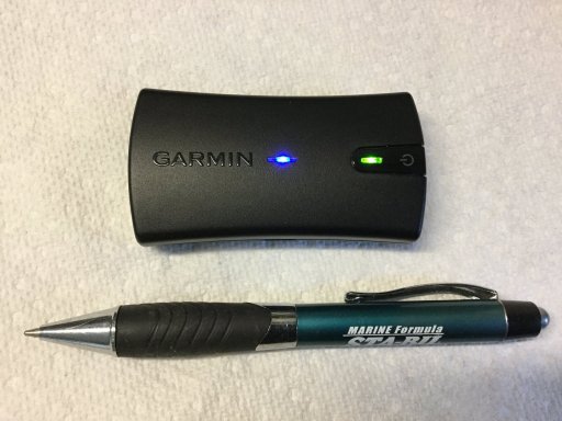
I run my Ipad with a External Bluetooth GPS receiver and it does great. I have the Skypro GPS receiver.
 
  • Like
Reactions: Battle-Spec

smritte

Rank V
Launch Member

Member III

2,827
Ontario California
First Name
Scott
Last Name
SMR
Member #

8846

Ham/GMRS Callsign
KO6BI
Well.... lol. I actually bought a new iPad about 6 months ago, solely for the use of being my mapping and navigation unit in the rig. Sadly, I didn’t do enough research and found out that iPads have the least reliable GPS when they disconnect from cellular. I bought the premium GAIA membership and started saving some trails, and it seemed all good until I actually went off grid and couldn’t get it to keep up with where i was at. So with more research, I found out that Samsung has the best internal GPS of all tablet systems. I may just have to buy yet another tablet and start fresh


That's interesting. IPad uses both American and Russian (GLOSNAS) satellites. I've been in narrow canyons with my Ipad and still had enough keep tracking. Obviously, too narrow of a canyon and it will stop tracking. I have seen where people mount their tablet low in a metal hard top vehicle get poor coverage. I use to have an older android tablet that only tracked the american satellites. Mounted on top of my TJ dash, it worked well.

didn’t do enough research and found out that iPads have the least reliable GPS when they disconnect from cellular.
When I bought my Ipad 4 years ago, nothing in the tablet world was remotely better.

Kind of a dumb question but, did you turn on the GPS in your tablet? It defaults off. There's no reason to lose gps once you get off cellular unless your in tall narrow mountains or dense forest. Even with a lesser unit.
 
Last edited:

Battle-Spec

Rank III
Launch Member

Enthusiast II

509
Cartersville, GA, USA
First Name
Dan
Last Name
Proctor
Member #

23653

Well.... lol. I actually bought a new iPad about 6 months ago, solely for the use of being my mapping and navigation unit in the rig. Sadly, I didn’t do enough research and found out that iPads have the least reliable GPS when they disconnect from cellular. I bought the premium GAIA membership and started saving some trails, and it seemed all good until I actually went off grid and couldn’t get it to keep up with where i was at. So with more research, I found out that Samsung has the best internal GPS of all tablet systems. I may just have to buy yet another tablet and start fresh


That's interesting. IPad uses both American and Russian (GLOSNAS) satellites. I've been in narrow canyons with my Ipad and still had enough keep tracking. Obviously, too narrow of a canyon and it will stop tracking. I have seen where people mount their tablet low in a metal hard top vehicle get poor coverage. I use to have an older android tablet that only tracked the american satellites. Mounted on top of my TJ dash, it worked well.

didn’t do enough research and found out that iPads have the least reliable GPS when they disconnect from cellular.
When I bought my Ipad 4 years ago, nothing in the tablet world was remotely better.

Kind of a dumb question but, did you turn on the GPS in your tablet? It defaults off. There's no reason to lose gps once you get off cellular unless your in tall narrow mountains or dense forest. Even with a lesser unit.
Well I actually bought an iPad that didn’t have cellular, not knowing that that means it has to be tethered to something else to use GPS. And my comment about the GPS was from both trying to use GAIA on my iPad and iPhone and not showing in the correct location, and the online explanation of companies like Garmin and lifetime trails who explained that they use Samsung tablets bc they are the most accurate off road GPS available
 

smritte

Rank V
Launch Member

Member III

2,827
Ontario California
First Name
Scott
Last Name
SMR
Member #

8846

Ham/GMRS Callsign
KO6BI
Well I actually bought an iPad that didn’t have cellular, not knowing that that means it has to be tethered to something else to use GPS. And my comment about the GPS was from both trying to use GAIA on my iPad and iPhone and not showing in the correct location, and the online explanation of companies like Garmin and lifetime trails who explained that they use Samsung tablets bc they are the most accurate off road GPS available
Ahh didnt see that.
As for using this brand or that. Pretty much all of your modern gps tablets are overkill. They track all the satellites and have good antennas. It's more about what you like. It doesn't matter if the gps tracks 100000 satellites when there's only 7 on the horizon or 3 in the narrow canyon. I wouldn't be surprised if most of the people who say this is better than that, were given the tablet for free. People also want the best even if it really makes no difference.
Over the last 10 odd years i've gone through a bunch of tablets and software looking for whats "best". It really got down to the software. I think you will be happy with which ever you end up with, including running an external antenna on your Ipad.
 
  • Like
Reactions: Battle-Spec

Flipper

Rank V
Launch Member

Member III

2,865
Florida
First Name
John
Last Name
F
Member #

5021

I use a Garmin GLO2 with my Ipad . Just turn it on links via Bluetooth. Excellent receiver even works on console. Run about 8hrs on a charge or you can plug it in with usb cableD3C9E2CA-43C6-4C48-86DF-CD083B60308A.jpeg
 

Hafaday

Rank V
Launch Member

Pathfinder I

2,271
Richmond, VA.
Member #

7455

The Garmin Glo is nice. I have one myself and it works great. I have played around with it several times along side a standard GPS.. the Glo is right on, for an added BT GPS. There are other devices out there as well.

One time messing around, I purposely cached only part of a map in the Google maps app. on my IPad. The GLO still tracked me off the map (When zoomed out some), then back on a few miles later where the map download came back into play.

As for an out of the box GPS that will do what you are Looking for.. that is on you. My opinion is even with a stand alone GPS, you will still want to research where you want to go. Weather by means of online or word of mouth.

This is pretty decent for forest roads in the National Parks System. As for updates with it, not to sure on that. But you can click on said forest road or what have you. And it will give you some info. Have fun playing with it. Forest Service Visitor Map

Also. if you state has MVUM (Motor Vehicle Use Maps) in park systems. I’d highly look into them. Some may be open year around, other might not, as in a seasonal forest road.
 

Flipper

Rank V
Launch Member

Member III

2,865
Florida
First Name
John
Last Name
F
Member #

5021

The Garmin Glo is nice. I have one myself and it works great. I have played around with it several times along side a standard GPS.. the Glo is right on, for an added BT GPS. There are other devices out there as well.

One time messing around, I purposely cached only part of a map in the Google maps app. on my IPad. The GLO still tracked me off the map (When zoomed out some), then back on a few miles later where the map download came back into play.

As for an out of the box GPS that will do what you are Looking for.. that is on you. My opinion is even with a stand alone GPS, you will still want to research where you want to go. Weather by means of online or word of mouth.

This is pretty decent for forest roads in the National Parks System. As for updates with it, not to sure on that. But you can click on said forest road or what have you. And it will give you some info. Have fun playing with it. Forest Service Visitor Map

Also. if you state has MVUM (Motor Vehicle Use Maps) in park systems. I’d highly look into them. Some may be open year around, other might not, as in a seasonal forest road.
You can get Garmin updates free on their website. I run Gaia Premium, loads of map, sat, old topos, coastal marine charts,USFS. You can record your track. One feature I really like , when I take pictures on my Nikon pocket camera during the trip. When we get back home there is a prompt that you click on and it loads all the pix onto the saved route with a pin where the pix was taken and where you can add info with just a click. It used to take me hours to find the locations again to load the pix. It’s really cool watching your rig REAL TIME on Google Earth on the trails. Big thing you can see on each side of the trails you wouldn’t have know they were there. The 1900 an 1930 topos are great for finding and exploring structures sites that are long gone.
 
Last edited:
  • Like
Reactions: Hafaday

Flipper

Rank V
Launch Member

Member III

2,865
Florida
First Name
John
Last Name
F
Member #

5021

With the GLO2 no cell service required to operate with your IPad. We also have a Verizon Hotspot for Internet while on the road.
 

Battle-Spec

Rank III
Launch Member

Enthusiast II

509
Cartersville, GA, USA
First Name
Dan
Last Name
Proctor
Member #

23653

The Garmin Glo is nice. I have one myself and it works great. I have played around with it several times along side a standard GPS.. the Glo is right on, for an added BT GPS. There are other devices out there as well.

One time messing around, I purposely cached only part of a map in the Google maps app. on my IPad. The GLO still tracked me off the map (When zoomed out some), then back on a few miles later where the map download came back into play.

As for an out of the box GPS that will do what you are Looking for.. that is on you. My opinion is even with a stand alone GPS, you will still want to research where you want to go. Weather by means of online or word of mouth.

This is pretty decent for forest roads in the National Parks System. As for updates with it, not to sure on that. But you can click on said forest road or what have you. And it will give you some info. Have fun playing with it. Forest Service Visitor Map

Also. if you state has MVUM (Motor Vehicle Use Maps) in park systems. I’d highly look into them. Some may be open year around, other might not, as in a seasonal forest road.
You can get Garmin updates free on their website. I run Gaia Premium, loads of map, sat, old topos, coastal marine charts,USFS. You can record your track. One feature I really like , when I take pictures on my Nikon pocket camera during the trip. When we get back home there is a prompt that you click on and it loads all the pix onto the saved route with a pin and where you can add info with just a click. It used to take me hours to find the locations again to load the pix. It’s really cool watching your rig REAL TIME on Google Earth on the trails. Big thing you can see on each side of the trails you wouldn’t have know they were there. The 1900 an 1930 topos are great for finding and exploring structures sites that are long gone.
I have the premium Gaia, but honestly I haven’t learned to use it to it’s full potential. I really need to quit making excuses and get outdoors and just play with it until I’m more comfortable. I have enjoyed the multi layers when I’ve searched for routes I want to go to though.
 

smritte

Rank V
Launch Member

Member III

2,827
Ontario California
First Name
Scott
Last Name
SMR
Member #

8846

Ham/GMRS Callsign
KO6BI
One of the best ways to learn your software is, use it going to work, store..... When I get something new either software or GPS, I learn it that way. Nothing more frustrating then being out of cell range and having to look up a feature you know it has. As posted Gaia updates your online map with anything you recorded and saved.
 
  • Like
Reactions: Hafaday and Flipper

Flipper

Rank V
Launch Member

Member III

2,865
Florida
First Name
John
Last Name
F
Member #

5021

I have the premium Gaia, but honestly I haven’t learned to use it to it’s full potential. I really need to quit making excuses and get outdoors and just play with it until I’m more comfortable. I have enjoyed the multi layers when I’ve searched for routes I want to go to though.
Same here. I stumbled across the multi-pix download by accident. The multi layers are one of the best features, just like you said. Another great site for multi- layering is historicaerials.com ,you type in a location, it brings up every topo made in chronological order. Some topos date waaaaaay back . Then you can overlay or wipe any date topo or aerial photograph over your original choice. This way when you look at the early topos and start working up thru in time you can see when things were built and things change thru time when they show up on the newer maps. Pretty cool.
 

smritte

Rank V
Launch Member

Member III

2,827
Ontario California
First Name
Scott
Last Name
SMR
Member #

8846

Ham/GMRS Callsign
KO6BI
I never looked at the GLO2 until now. The spec's on that rock. Does it come with built in street mapping or is it just a receiver? I see a free 6 month subscription to Garmin Pilot, im assuming that is for flying.
 

Flipper

Rank V
Launch Member

Member III

2,865
Florida
First Name
John
Last Name
F
Member #

5021

One of the best ways to learn your software is, use it going to work, store..... When I get something new either software or GPS, I learn it that way. Nothing more frustrating then being out of cell range and having to look up a feature you know it has. As posted Gaia updates your online map with anything you recorded and saved.
I used to teach seminars at West Marine on GPS’s/Navagation. I would teach how to read charts, waypoints, routes, load a go to, what the numbers in a lon and lat are and how to locate that point on a chart. It was very rewarding when some one gets an understanding of navigation, it’s almost like seeing a lightbulb going off above their head when the get it. They would always ask me how can I remember how to run all the different models. My response was “ If you can run one Garmin you can run them all” and they are simple to operate. With the technical challenged..... “ If you can operate a cell phone I can teach you how to use a Garmin”
 
  • Like
Reactions: smritte

Flipper

Rank V
Launch Member

Member III

2,865
Florida
First Name
John
Last Name
F
Member #

5021

I never looked at the GLO2 until now. The spec's on that rock. Does it come with built in street mapping or is it just a receiver? I see a free 6 month subscription to Garmin Pilot, im assuming that is for flying.
It is just a receiver that links to your phone or IPad
 
  • Like
Reactions: smritte

Battle-Spec

Rank III
Launch Member

Enthusiast II

509
Cartersville, GA, USA
First Name
Dan
Last Name
Proctor
Member #

23653

My GLO2 came in and I tried it out on the iPad. It linked really fast and had no issues while driving around. I think I’m really gonna like it. Now if I could just find more saved tracks for off road trails around here in the east, I’ll be good to go, I think.
 
  • Like
Reactions: Hafaday

Two Sheds

Rank V
Launch Member

Traveler III

1,872
Hayden, Idaho, United States
First Name
Andy
Last Name
Jacobson
Member #

8616

A couple questions, you guys with iPads- how /where do you secure them while traveling? Nothing worse than reaching to the screen only to have it vibrate to death then fall to the floor and how do you maintain an on line connection so the map stays with your progress or lack of. ? I’m not looking for a full time bracket that looks like I’m driving a DJ booth.