Is there some way to make the map more legible?

  • HTML tutorial

kunstmilch

Rank V
Member

Advocate II

1,597
Pomona, CA, USA
First Name
Erich
Last Name
Wise
Member #

29953

Ham/GMRS Callsign
GMRS call sign: WRFL229
I have played with all the filters and layers etc. I really really want to like and use this app for more than the forum. The problem seems to remain this map is illegible and difficult to use for me and my partner, of the four main apps we have tried out (I used to just use paper maps for basic rout and then wing it while out there, but trying to see if this is better) 1. Apple/google maps 2. Gaia 3. OB1 4. OnX Off-road. This is the most difficult to use, too frustrating to actually be useful out on the trail.

Somehow Gaia is easier to use than OB1 which is saying something. Perhaps I just dont get it. Gaia now seems to crash my old iPad, OB1 does the same on occasion though. I've looked at all the tutorials, and they are sort of helpful, but at the end of the day trying to actually use it has left me frustrated and feeling dumb.
 

Ubiety

Rank VI
Member

Explorer I

5,221
Sammamish, WA, USA
First Name
Greg
Last Name
Ubiety
Member #

6193

Ham/GMRS Callsign
Ribs
Can you describe "this map is illegible and difficult to use" with a little more detail? What map view are you using? Are you speaking of planning activities or while navigating? Have you tried different "views" in the map settings (icon with one square hovering over a second square)? Are you using it to navigate outside of cell service when you have not previously downloaded offline maps for the area? If using while navigating what "follow mode" are you using (the little target/crosshairs icon)? Perhaps changing this will help?

I use the filters to get rid of most of the clutter; too much clutter to leave everything unfiltered.
 

Ocean_Ranger

Rank VI
Member

Expedition Master I

5,125
Santa Barbara, CA, USA
First Name
Sean
Last Name
Pickton
Member #

30373

Ham/GMRS Callsign
N6SRP (GMRS WROQ518)
After a season of using both Gaia and OnX, I find myself using OnX and won’t be renewing my Gaia subscription.

I’ve recently upgraded my OB subscription to have access to offline maps. My plan is to use OnX and OB1 for a while and compare. I have struggled a bit in planning a trip with OB1. After searching in the forum for a bit I haven’t found a great tutorial for OB1 map use. Are there any specific threads or videos that you’d recommend? One of my favorite features of OnX and Gaia is that I can create a route at home and then download the planned route to use offline. Is there a way to do this in OB1?

I’m sure that I’m missing some easy tips and tricks…
 
  • Like
Reactions: Ubiety

Ocean_Ranger

Rank VI
Member

Expedition Master I

5,125
Santa Barbara, CA, USA
First Name
Sean
Last Name
Pickton
Member #

30373

Ham/GMRS Callsign
N6SRP (GMRS WROQ518)
Ok, one other quick question. What are the 1 and 0 icons that are placed around the map?
 

Ubiety

Rank VI
Member

Explorer I

5,221
Sammamish, WA, USA
First Name
Greg
Last Name
Ubiety
Member #

6193

Ham/GMRS Callsign
Ribs
After a season of using both Gaia and OnX, I find myself using OnX and won’t be renewing my Gaia subscription.
Ex Gaia user and I LOVE the onX maps as well! I do find the OB1 maps to be very similar to the onX maps - at least when comparing to what Gaia offers. Trip planning will get better with OB1 soon as they are working on a web based UI to allow planning to happen on a computer rather than just on a handheld device. And if it is not in there already - there will be road following in OB1 when you are laying down a new route - something that onX did not have last time that I looked (a couple months back). Its been a crazy summer...

I am in the same boat, running all three while navigating (OB1, onX and Gaia) and have to say that I prefer OB1 at this point. Each has its own set of strengths and weaknesses but I really like navigating with OB1 as well as the awesome support and the quickness with which they are iterating and making things better.

I use the filter functionality in OB1 to reduce the clutter to the few things that I am interested in - perhaps I am filtering the 1s and 0s out because I don't see them. Do you have a screen shot? Are your filters set / not-set? What happens if you poke at one - doe you get some descriptive text that might help inform what their purpose is?
 

M Rose

Local Expert
Mod Team
Member

Advocate III

5,584
Northeast Oregon, United States
First Name
Michael
Last Name
Rose
Member #

20990

Ham/GMRS Callsign
W7FSB
Service Branch
US ARMY Retired
After a season of using both Gaia and OnX, I find myself using OnX and won’t be renewing my Gaia subscription.

I’ve recently upgraded my OB subscription to have access to offline maps. My plan is to use OnX and OB1 for a while and compare. I have struggled a bit in planning a trip with OB1. After searching in the forum for a bit I haven’t found a great tutorial for OB1 map use. Are there any specific threads or videos that you’d recommend? One of my favorite features of OnX and Gaia is that I can create a route at home and then download the planned route to use offline. Is there a way to do this in OB1?

I’m sure that I’m missing some easy tips and tricks…
threads about OB1:

Tutorials:

@Michael is working on a very in-depth document on how-to use OB1.


Ex Gaia user and I LOVE the onX maps as well! I do find the OB1 maps to be very similar to the onX maps - at least when comparing to what Gaia offers. Trip planning will get better with OB1 soon as they are working on a web based UI to allow planning to happen on a computer rather than just on a handheld device. And if it is not in there already - there will be road following in OB1 when you are laying down a new route - something that onX did not have last time that I looked (a couple months back). Its been a crazy summer...
From my understanding of “Road Fallowing “ it will be implemented in a couple of weeks with route planning. The Dev team is working very hard to get this out to us as soon as they can. @Michael is waiting until they have a very robust and polished product before it’s released. I have personally seen the new UI and it’s looking great. I’m hoping it’s as easy to use as the demo makes it look.
 

Michael

Rank IX
Staff member
Founder 500
Member

Benefactor

15,584
Livermore, California, United States
First Name
Michael
Last Name
Murguia
Member #

0000

Ham/GMRS Callsign
KM6YSL
I have played with all the filters and layers etc. I really really want to like and use this app for more than the forum. The problem seems to remain this map is illegible and difficult to use for me and my partner, of the four main apps we have tried out (I used to just use paper maps for basic rout and then wing it while out there, but trying to see if this is better) 1. Apple/google maps 2. Gaia 3. OB1 4. OnX Off-road. This is the most difficult to use, too frustrating to actually be useful out on the trail.

Somehow Gaia is easier to use than OB1 which is saying something. Perhaps I just dont get it. Gaia now seems to crash my old iPad, OB1 does the same on occasion though. I've looked at all the tutorials, and they are sort of helpful, but at the end of the day trying to actually use it has left me frustrated and feeling dumb.
Thank you Erich! Until we get this right, we are failing - so please know we take everything stated here as VERY important. Especially since I created OB1 by being frustrated by the others. To hear we are more frustrating to some means we have work to do...so bring it! I'd really like your detailed feedback!

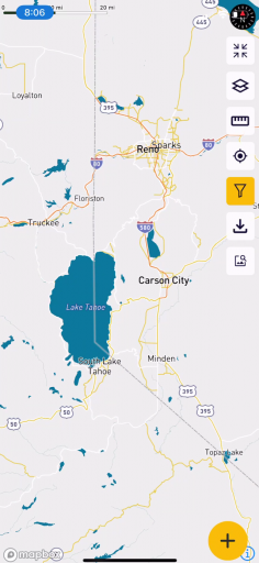
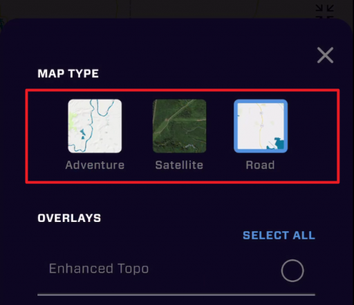
Now, from a pure visibility standpoint, if there is just too much (and I get that), I might strip down everything, and then start adding back information you need. If you turn everything off, you can then select your "Base Layer". With everything off, the base layers look like:

1659798433320.png 1659798392050.png 1659798481521.png

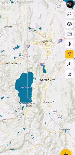
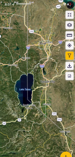
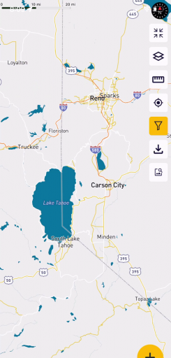
These base layers are Adventure, Satellite, and Road base layers, and each has a separate focus. If the base layers are no good for you, with an example of what you like, we may be able to release a new base layer that accommodates you. We'll call it the "Wise" layer. Oh - sdelecting a base layer is in the layers screen here:

1659799521994.png

If you would like the full rundown of the base layers and what they are used for, this is one of the tutorials 
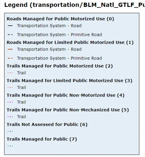
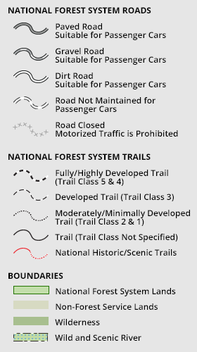
@M Rose was referring to that is complete. You might find this Filtering the Map tutorial helpful. It goes into some depth about filtering the map.

There is also a Map Quick Start. If you want to see the full scope of the written documentation for OB1, it'll be a bit frustrating because there are only a few done (I'm writing as fast as I can! :) ) Overland Bound One: Start Here but even what is complete might give you a good head start.

Erich, if you have the time - I would like to know that moment you kind of throw your hands up, and how we can make it better - beyond the map and the forums, and everything else, our goal is top provide information that makes it better to get out there for an adventure - so we want it to be easy!

Thanks again!
 

Attachments

  • Like
  • Love
Reactions: M Rose and Ubiety

Michael

Rank IX
Staff member
Founder 500
Member

Benefactor

15,584
Livermore, California, United States
First Name
Michael
Last Name
Murguia
Member #

0000

Ham/GMRS Callsign
KM6YSL
After a season of using both Gaia and OnX, I find myself using OnX and won’t be renewing my Gaia subscription.

I’ve recently upgraded my OB subscription to have access to offline maps. My plan is to use OnX and OB1 for a while and compare. I have struggled a bit in planning a trip with OB1. After searching in the forum for a bit I haven’t found a great tutorial for OB1 map use. Are there any specific threads or videos that you’d recommend? One of my favorite features of OnX and Gaia is that I can create a route at home and then download the planned route to use offline. Is there a way to do this in OB1?

I’m sure that I’m missing some easy tips and tricks…
Yes - we are building the written docs out here: Overland Bound One : Start Here and that is a focus next week so you will see the links in the TOC populated. We do have the video tutorials: Video Tutorials but I understand those move really fast, and not all learn visually.

Route planning is a week or so a way, and I will link a video to it below so you can see the functionality. It's really cool. in addition to route finding and the ability to change your routing mode, you can share the route with others and it retains its editing capability, or really tune your route and then export is as a GPX.

Web routing is something we know we need, but that's farther out. We wanted to get Mobile routing done first so people can use OB1 on the go.

As always - love your feedback!
 

Ocean_Ranger

Rank VI
Member

Expedition Master I

5,125
Santa Barbara, CA, USA
First Name
Sean
Last Name
Pickton
Member #

30373

Ham/GMRS Callsign
N6SRP (GMRS WROQ518)
@Michael thank you so much for your replies. I am really excited for route planning. This feature is MVP for me. Once it is rolled out I will definitely create, track and upload my routes. I think that this feature will enable more user generated routes to be uploaded. Thanks again and be safe out there.
 
  • Like
Reactions: Michael

Michael

Rank IX
Staff member
Founder 500
Member

Benefactor

15,584
Livermore, California, United States
First Name
Michael
Last Name
Murguia
Member #

0000

Ham/GMRS Callsign
KM6YSL
Hey all - since we are on the topic, just recorded this quick intro of Route planning going through the basics.

Did this real quick so please let me know if there is any personally identifiable information or something embarrassing :laughing:

Also - if you have feedback let me know!


Ubiety

Rank VI
Member

Explorer I

5,221
Sammamish, WA, USA
First Name
Greg
Last Name
Ubiety
Member #

6193

Ham/GMRS Callsign
Ribs
Hey all - since we are on the topic, just recorded this quick intro of Route planning going through the basics.

Did this real quick so please let me know if there is any personally identifiable information or something embarrassing :laughing:

Also - if you have feedback let me know!

Awesome possum! Thanks for the quick vid! I really like that:
- Route points are numbered - soothes my OCD ;)
- Routes can be colored - I make heavy use of colors
- Routes can be collaborated on (Awesome!)

When you are ready I do agree that some more detail on quick save vs. "editable uploaded route" will be important. For instance (and you don't need to answer now) - is an "editable uploaded route" public and/or private? If there is a difference then how do I enforce my intention? Also think a general video on quick save vs. save/upload would be beneficial.

Now I am itching to try this on the iPad with a mouse! That may be killer!
 

M Rose

Local Expert
Mod Team
Member

Advocate III

5,584
Northeast Oregon, United States
First Name
Michael
Last Name
Rose
Member #

20990

Ham/GMRS Callsign
W7FSB
Service Branch
US ARMY Retired
Ok, I searched around in OB1 and cannot find the map legend. Can anybody lend me a clue? ;)
Not the answer you were looking for I know…


Hi there - this is all very new to our app, so thank you for testing and providing feedback! It will get much more simple.


Quick answers:


On the trail tab you will see two types of trails for now:

- USFS Roads

- GPX files uploaded from Members.


The USFS road trails follow the USFS legend - so:


legend-static-only-png.204739.png1659812179996.png


The GPX files should have trail ratings added by the person who uploaded them.


You bet. Great suggestion. We absolutely need to have all legends in app.


For blm we do separate land from roads. Good not on USFS roads vs trails.


Lots of great work ongoing, dropping releases regularly. Route planning is very exciting and releasing in the next few weeks. Currently hardening offline saves and upload handling in patchy service.[\QUOTE]


https://www.overlandbound.com/forums/threads/map-help.39488/#post-622366
 
  • Like
Reactions: Michael and Ubiety

El-Dracho

Ambassador, Europe
Moderator
Member
Supporter
Investor

Inventor I

13,232
Lampertheim, Germany
First Name
Bjoern
Last Name
Eldracher
Member #

20111

Ham/GMRS Callsign
DO3BE
Hey all - since we are on the topic, just recorded this quick intro of Route planning going through the basics.

Did this real quick so please let me know if there is any personally identifiable information or something embarrassing :laughing:

Also - if you have feedback let me know!

Thank you for the vid @Michael

Awesome. I think that kind of quick video upates are great for the community, Well done.

I am excited for the route planing feature.

Thank you,
Bjoern