Garmin ecosystem thoughts.... or stamdalone devices?

  • HTML tutorial

kayasaman

Rank III

Enthusiast III

537
London, UK
First Name
Kaya
Last Name
Saman
Hi all,

I've been using a Garmin 67i (inReach) device for a while though I've never activated the inReach part as I have cell connection everywhere.... the idea behind it was to use it off-grid for planned places and since recently I started taking an interest in overlanding it just really integrates well.

As someone who is just starting out and researching lots of different things I'd like to hear thoughts on what people actually think about the Garmin system.


I'm actually quite linked into the Garmin eco-system myself with watches, scales, blood pressure monitor, and the GPSMAP. I actually find Garmin Explore and Connect really useful for logging activities and even planning them in terms of using waypoints as POI's in Explore then sync'ing that to my 67i GPSMAP.
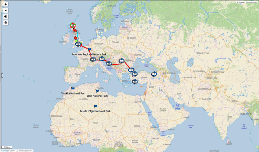
For a while now I am starting to create waypoints internationally when I find a place I like the look of and become interested in.

This is what I have currently come up with in Garmin Explore:
Screenshot at 2025-01-12 19-18-52.png

Recently I've been looking at the Tread Overland XL, and decided to play around with the Tread app. Once my activities were converted to "routes", I was able to see my journeys up to/around/and back from Scotland.


Something I'm also considering is that the Tread device also integrates with a rear view camera which is great to have installed on a trailer (which I'm looking at potentially) and the "Group Ride Tracker" which also functions as a 2-way radio as far as I understand?
The main screen can also control the trailer systems like water, hvac, lighting, power, etc... through the Garmin main controller unit (which comes standard on all Pause trailers).


Has anybody actually done things this way and can comment on it?


I don't think the Garmin will be a replacement for a dual band 2-way radio like the vehicle mount ICOM ID-5100E that I have in mind or handheld ICOM ID-50E.


How does the Garmin navigation system compare to something like ON-X in addition? I have Waze which I use for daily stuff and treat the Garmin and that as completely separate systems. I'm not sure if Waze can even import GPX files?


Oh and last question is when traveling internationally by road how does that effect 2-way radio usage? I am aware that every country has allocated frequency ranges that are free to use but those change from country to country. I guess the dual band ICOM won't have any issues, as I've seen the ExpeditionOverland guys use them around the world. It's probably just a matter of being aware of what frequency bands you need to operate in I guess.....
 
  • Like
Reactions: macr88

macr88

Rank VII
Launch Member

Expedition Master III

5,643
Emmett, ID, USA
First Name
Mac
Last Name
Raslan
Member #

4788

Ham/GMRS Callsign
KJ7TLH or GMRS WRBM678
Service Branch
Sweet District II
I recently came across the tread overlander and it looks interesting, would be nice to use that camera up front.
Had no idea that it had the ability to control other devices. Could possibly be used as lighting controller or to control other devices on the rig?

I use Garmin Earthmate that comes with my inReach mini and I get the feeling they have two mapping systems of different tiers Earthmate being on the lower end of things but I don’t know this for sure. I think the Tread would give you their better mapping system. Not sure what the 67i gives you for a mapping system.
 
  • Like
Reactions: kayasaman

kayasaman

Rank III

Enthusiast III

537
London, UK
First Name
Kaya
Last Name
Saman
Hi there,

thanks for the response!

I almost thought this thread would go unanswered as it's a bit niche....

I recently came across the tread overlander and it looks interesting, would be nice to use that camera up front.
Had no idea that it had the ability to control other devices. Could possibly be used as lighting controller or to control other devices on the rig?
Check the ROA (RV's of America) videos on Youtube for the Pause trailers:


They run the Garmin OEM system:


It integrates completely with the Tread series....


Similar to RedArc controllers or for home automation and control systems like Control4, Crestron and Elan or what I use which is the GCE Electronics IPX system from France.


I use Garmin Earthmate that comes with my inReach mini and I get the feeling they have two mapping systems of different tiers Earthmate being on the lower end of things but I don’t know this for sure. I think the Tread would give you their better mapping system. Not sure what the 67i gives you for a mapping system.

Not quite! The mapping system is the same....

I'm not sure about Earthmate? I recall that there was a legacy system so perhaps that might be it?? - don't quote me on that though....

As far as I am aware, Garmin Explore is the system that everything integrates with.

This makes life exceptionally easy as you can pop Waypoints on your handheld like the 66 or 67 series or even watch like Tactix, Fenix etc.... and if the "Collection" is set to be sync'ed with other devices like the Tread, you can have them all appearing there.


Another words: watches, handhelds and dedicates in-vehicle navigators can all communicate with each other.


For more info: Garmin Explore™
 
  • Like
Reactions: macr88

macr88

Rank VII
Launch Member

Expedition Master III

5,643
Emmett, ID, USA
First Name
Mac
Last Name
Raslan
Member #

4788

Ham/GMRS Callsign
KJ7TLH or GMRS WRBM678
Service Branch
Sweet District II
Can’t say I answered anything as it was mostly me blabbing away.

I downloaded the tread iPhone app and it’s completely different than Earthmate.
Earthmate is more like a paper map where Tread is a map designed for digital use, far easier to see POI’s and actual trails.

Now I’m considering a Tread Overlander. I’ve watched a few videos and my only gripe is that it seems under powered or it lags just a bit but not a big deal.
Creating routes is crazy easy and even better is that changing a route on the fly is just as easy.

Currently using Garmin Earthmate, Avenza, Apple Maps and Trails off road.
With Tread Overlander it would just be that and Trails Off Road, would make exploring far easier. It looks like I’d be able to install Trails Off road on to the tread Overlander device which would be nice.

All my POI’s transferred over to the tread iPhone app along with my routes. My tracks did not, or maybe I need to enable them somewhere.

My only other Garmin device is for my bicycle and I don’t see myself syncing that to the tread.

The RV system is pretty slick.

I tried OnX a while back but didn't like it
 

Attachments

  • Like
Reactions: kayasaman

kayasaman

Rank III

Enthusiast III

537
London, UK
First Name
Kaya
Last Name
Saman
Can’t say I answered anything as it was mostly me blabbing away.

I downloaded the tread iPhone app and it’s completely different than Earthmate.
Earthmate is more like a paper map where Tread is a map designed for digital use, far easier to see POI’s and actual trails.

Now I’m considering a Tread Overlander. I’ve watched a few videos and my only gripe is that it seems under powered or it lags just a bit but not a big deal.
Creating routes is crazy easy and even better is that changing a route on the fly is just as easy.

Currently using Garmin Earthmate, Avenza, Apple Maps and Trails off road.
With Tread Overlander it would just be that and Trails Off Road, would make exploring far easier. It looks like I’d be able to install Trails Off road on to the tread Overlander device which would be nice.

All my POI’s transferred over to the tread iPhone app along with my routes. My tracks did not, or maybe I need to enable them somewhere.

My only other Garmin device is for my bicycle and I don’t see myself syncing that to the tread.

The RV system is pretty slick.

I tried OnX a while back but didn't like it

I remember I also had some issue with my recordings done with the 67i. Basically my whole Scotland trip.....

There was a way I sorted this by converting the route.... I think it was by clicking "save a copy" or was it via "share"? - or did I go into the "Connect" app then save the route to "My Courses"?


I think it was this? Garmin Explore Web Help Owner's Manual - Converting a Track to a Route


This is just an FYI but these guys are using either the Garmin Montana: Garmin Montana® 710 | Handheld Touchscreen GPS

or eTrex device for their navigation: Garmin eTrex® Solar | Hiking GPS Handheld

 
Last edited:
  • Like
Reactions: macr88

macr88

Rank VII
Launch Member

Expedition Master III

5,643
Emmett, ID, USA
First Name
Mac
Last Name
Raslan
Member #

4788

Ham/GMRS Callsign
KJ7TLH or GMRS WRBM678
Service Branch
Sweet District II
I remember I also had some issue with my recordings done with the 67i. Basically my whole Scotland trip.....

There was a way I sorted this by converting the route.... I think it was by clicking "save a copy" or was it via "share"? - or did I go into the "Connect" app then save the route to "My Courses"?


I think it was this? Garmin Explore Web Help Owner's Manual - Converting a Track to a Route


This is just an FYI but these guys are using either the Garmin Montana: Garmin Montana® 710 | Handheld Touchscreen GPS

or eTrex device for their navigation: Garmin eTrex® Solar | Hiking GPS Handheld


kayasaman

Rank III

Enthusiast III

537
London, UK
First Name
Kaya
Last Name
Saman
I remember I also had some issue with my recordings done with the 67i. Basically my whole Scotland trip.....

There was a way I sorted this by converting the route.... I think it was by clicking "save a copy" or was it via "share"? - or did I go into the "Connect" app then save the route to "My Courses"?


I think it was this? Garmin Explore Web Help Owner's Manual - Converting a Track to a Route


This is just an FYI but these guys are using either the Garmin Montana: Garmin Montana® 710 | Handheld Touchscreen GPS

or eTrex device for their navigation: Garmin eTrex® Solar | Hiking GPS Handheld

There's no text in the response? It looks like a possible system glitch lol...
 
  • Like
Reactions: macr88

macr88

Rank VII
Launch Member

Expedition Master III

5,643
Emmett, ID, USA
First Name
Mac
Last Name
Raslan
Member #

4788

Ham/GMRS Callsign
KJ7TLH or GMRS WRBM678
Service Branch
Sweet District II
There's no text in the response? It looks like a possible system glitch lol...
I don’t even remember what I said lol

I do watch them but not on YouTube, they use a bunch of garmin stuff and I want to say I saw them with the Overlander XL. When I saw it I thought it was just a tablet with a cool case and the garmin app.

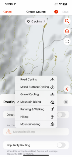
My old inReach mini only has support for Earthmate so explore and tread are limited in functionality. I can’t create a driving route, can you choose different vehicles with yours or is that what the tread app does?IMG_1375.png

I think I’ve finally made my mind up on the Tread 2. Now I just need a discount code.
 
  • Like
Reactions: kayasaman

kayasaman

Rank III

Enthusiast III

537
London, UK
First Name
Kaya
Last Name
Saman
I don’t even remember what I said lol

I do watch them but not on YouTube, they use a bunch of garmin stuff and I want to say I saw them with the Overlander XL. When I saw it I thought it was just a tablet with a cool case and the garmin app.

My old inReach mini only has support for Earthmate so explore and tread are limited in functionality. I can’t create a driving route, can you choose different vehicles with yours or is that what the tread app does?View attachment 288928

I think I’ve finally made my mind up on the Tread 2. Now I just need a discount code.
Oh wow! Good luck with the Tread :-) :-) :-)

Post back here on how you get on with it.... I'm sure it will be quite useful to many people ;-)

My 67i I think has two options: Walking and Other?? I will need to check but it certainly doesn't have driving. For that I need to change the setting in Connect but can't seem to do it in Explore.

I *was* able to convert the recorded tracks? to routes? though.... it gets a little confusing with the terminology as it's something I don't use everyday.... especially recently sadly
 
  • Like
Reactions: macr88

kayasaman

Rank III

Enthusiast III

537
London, UK
First Name
Kaya
Last Name
Saman
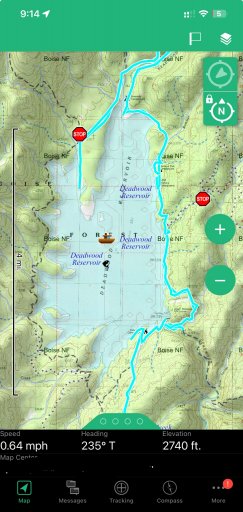
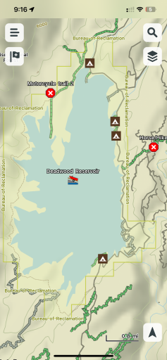
Seems like the Tread app has a more complete trail system?

Which layer do you have active?

I think Explore gives you Topo, Topo+, Road, and Satellite views; which is more centric to multi activities then the Tread which is specifically for driving/riding
 

kayasaman

Rank III

Enthusiast III

537
London, UK
First Name
Kaya
Last Name
Saman
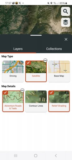
Tread gives you Driving, Satellite and Basemap

I guess it's gone be more comprehensive, though Explore does have everything as far as I can tell
 

Attachments

macr88

Rank VII
Launch Member

Expedition Master III

5,643
Emmett, ID, USA
First Name
Mac
Last Name
Raslan
Member #

4788

Ham/GMRS Callsign
KJ7TLH or GMRS WRBM678
Service Branch
Sweet District II
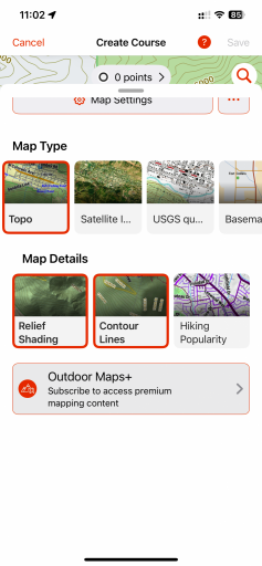
Which layer do you have active?

I think Explore gives you Topo, Topo+, Road, and Satellite views; which is more centric to multi activities then the Tread which is specifically for driving/riding
IMG_1378.png
 

kayasaman

Rank III

Enthusiast III

537
London, UK
First Name
Kaya
Last Name
Saman
Which layer do you have active?

I think Explore gives you Topo, Topo+, Road, and Satellite views; which is more centric to multi activities then the Tread which is specifically for driving/riding
View attachment 288932
Normally i use the satellite or road layers in Explore

Especially when cross-comparing Google Maps content, if there's a POI in Google and not on the Garmin
 

macr88

Rank VII
Launch Member

Expedition Master III

5,643
Emmett, ID, USA
First Name
Mac
Last Name
Raslan
Member #

4788

Ham/GMRS Callsign
KJ7TLH or GMRS WRBM678
Service Branch
Sweet District II
Tread gives you Driving, Satellite and Basemap

I guess it's gone be more comprehensive, though Explore does have everything as far as I can tell
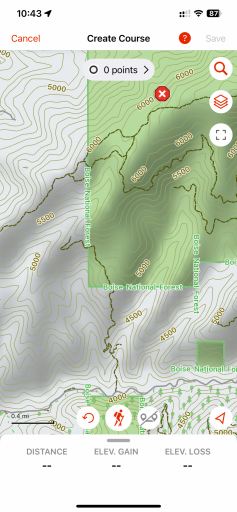
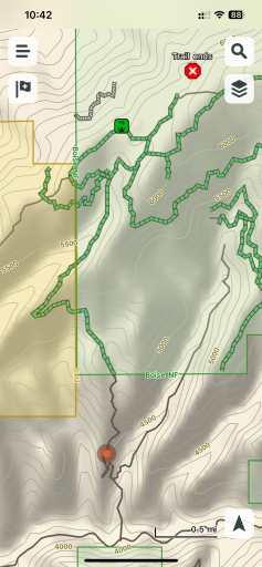
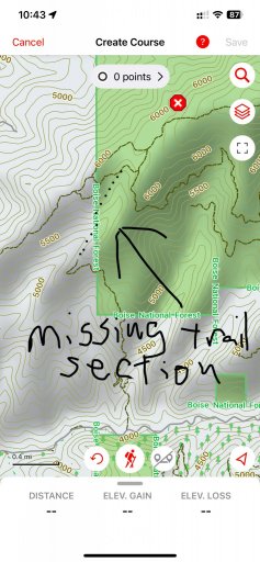
Explore really shouldn’t be missing this section that tread has. I have yet to run this trail but by looking at satellite images, it does look like it continues and connects where’s Explore shows it ending in the trees.
IMG_1377.jpeg
 

kayasaman

Rank III

Enthusiast III

537
London, UK
First Name
Kaya
Last Name
Saman
Tread gives you Driving, Satellite and Basemap

I guess it's gone be more comprehensive, though Explore does have everything as far as I can tell
Explore really shouldn’t be missing this section that tread has. I have yet to run this trail but by looking at satellite images, it does look like it continues and connects where’s Explore shows it ending in the trees.
View attachment 288933
I have also seen this....

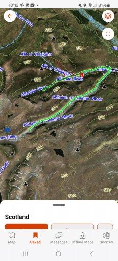
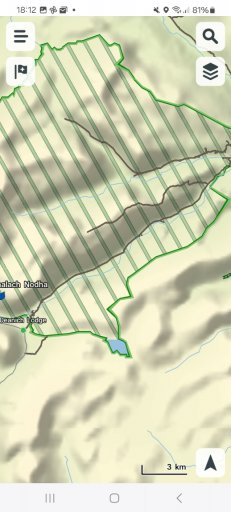
Cross comparing Explore and Tread during my Alladale Scotland trip:

Looks like "Road" portion in Explore is only for the web based version
 

Attachments

  • Like
Reactions: macr88

Kevin108

Rank V
Launch Member

Member III

2,741
Virginia Beach, VA
Member #

6632

When I started with my off-road maps, I had an old DeLorme inReach, which I still use, so I tried the Garmin maps, Gaia GPS, and marked a lot of trails up with Google Maps. I need to test it a bit more, but the last few trips I've had, I never used the inReach at all. Typically I would use it when I found camp for the night to send a location so family at home knew my whereabouts. With free (as of 2025) satellite messaging from my iPhone 15 Pro Max, I may discontinue the inReach service.
 
  • Like
Reactions: kayasaman

kayasaman

Rank III

Enthusiast III

537
London, UK
First Name
Kaya
Last Name
Saman
When I started with my off-road maps, I had an old DeLorme inReach, which I still use, so I tried the Garmin maps, Gaia GPS, and marked a lot of trails up with Google Maps. I need to test it a bit more, but the last few trips I've had, I never used the inReach at all. Typically I would use it when I found camp for the night to send a location so family at home knew my whereabouts. With free (as of 2025) satellite messaging from my iPhone 15 Pro Max, I may discontinue the inReach service.
It really depends on how one likes to work....

For me, I discovered that I like logging my journeys and where I hike or walk. The 67i is really ideal for that....

Also my phone battery doesn't last long, around 6 hours while the Garmin's: my watch (Tactix 7 Pro) and 67i will last at least a week. - though the watch won't last long either if in GPS tracking mode....

Personally, I don't use the 67i for navigation unless on foot as I have Waze on my phone and as there's cell signal everywhere around me it's just easier. Though in the car I have it linked to USB charge cable continuously.

The satellite messaging on your iPhone maybe a US based thing? I don't even own an iPhone as mine's a Samsung S21 Ultra. I'm not sure how the inReach works over here as reading the small print off the Garmin website it says that you need to have an active satellite connection too?? Does that mean an Iridium subscription or so?
One day when I actually do activate the inReach I will probably call and ask Garmin to see what the dealio is there.... when I start traveling properly I will definitely need to do that!!


But for this thread I was trying to figure out if it was worth going for the Tread Overland XL as it has many other features such as ability to control a trailer and even use a backup camera for example installed on the trailer. I also checked On-X in the meantime and that looks like it's US and/or North America only so again unavailable in my region....
(getting fed up as we don't get anything... no SiriusXM radio or even iHeart Radio (though there is a way around that one ;-) ))