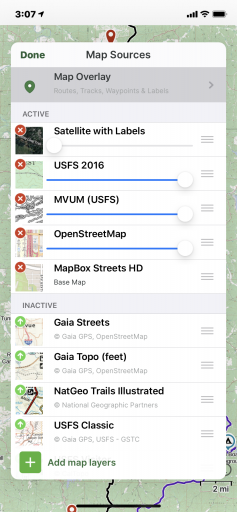
Gaia is not broken per se, it just doesn't reflect changes that have been made the the motor vehicle access areas. It shows trails and roads no matter the status although I did notice this past weekend that if you pay attention to the legend it does show the end of the official trail. But there is no signage or apparent change to the terrain as a result so it is very easy to end up in an area that is closed to motor vehicles.
At one point this weekend I realized that even though I was on a maintained (roughly) road, adjacent to private property, I was not on a trail or road that was even on Gaia. Was it a landowners road used to maintain fence rows? Old logging access road? I have no idea, and as soon as I realized I was out of bounds I found a safe place to turn around and went back the way I came. It can be very confusing. The only moderately accurate way I have found is to use Avenca with the MVUM as a pdf as the map, but that was not incredibly accurate in its ability to plot your location. I think my next step will be to run Gaia on my phone and Avenca on a tablet or other GPS enabled device. That will require buying a pan-a-vise mount or fabricating a dash bar to use RAM mounts on. At that point I will be looking at the screens more than the scenery...
The previous trip we made to MTNF some locals gave us a paper map of the MVUM and basically said in their interactions with the rangers your attitude about where you are, has a direct impact on how that interaction will go. My goal is to avoid being where I am not supposed to be. Having said that i pack out more than i bring in, don't tear up the roads, and make a strong effort to comply with the restrictions, correcting myself whenever I realize I am out of bounds. Not sure what else can be done, but I am working on improving my navigational systems to avoid any issues.


