Directions to Lost Coast Trail for Yeti and Yolo!

  • HTML tutorial

Toyotadirtdevil

Rank V
Launch Member

Influencer I

2,566
Carmichael, California
First Name
Michael
Last Name
Nantz
Member #

5150

4xFar Adventures

Rank VI
Founder 500
Launch Member

Benefactor

4,826
San Francisco,CA
First Name
Brenton
Last Name
Corns
Member #

0070

Sorry @Michael been sick for the past few days.

Usal Rd. is probably closed by now. This happens sometime in November, usually a week or two before Thanksgiving. Given all of the rain recently, it's for the best. To know for sure, you'd have to check the DoT for Mendo County.

Ok, I went and checked and it closed rather early this year, on Oct 13.
https://www.co.mendocino.ca.us/dot/roadClosures.htm

However, over the years I have learned that the part of Usal Rd. that goes to the beach/campground (from Hwy 1) is open all year long. The gate that is actually locked is just a few minutes drive from the beach, so you can at least visit there. It's pretty cool, with camping options among the trees, right at the tree line to the beach, or right along the hill on the northern side of the beach.
 

4xFar Adventures

Rank VI
Founder 500
Launch Member

Benefactor

4,826
San Francisco,CA
First Name
Brenton
Last Name
Corns
Member #

0070

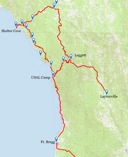
Here's a map of the Lost Coast trip I've done previously. I have a gps track but need to "track" it down.

From Laytonville, go North on 101 to Leggett
Head West on Hwy 1 until you're about to head South
Make a right onto USAL Rd. and head North until you hit the campground (you can look down at the camp/beach if traveling during daylight)
From there we continued north to Sinkyone Wilderness SP (Roosevelt Elk hang out here and USAL camp during the rut season)
Backtrack to USAL Rd and camp at either Nadelos or Wailaki Campgrounds
Next morning, head to Shelter Cove for breakfast and see the lighthouse
Head back to 101 and go South back to Leggett
Follow the track along Hwy1 (going West), and instead of turning north onto USAL Rd., continue South on Hwy 1
You'll eventually get to Fort Bragg and Glass Beach
When you've collected your glass head South through town until you reach Hwy 20 (Fort Bragg Rd.)
Turn left (East) on Hwy 20 and take it until it dumps you off in Willits at 101

Lost Coast Overall Map.jpg
 

Michael

Rank IX
Staff member
Founder 500
Member

Benefactor

15,584
Auburn, California, United States
First Name
Michael
Last Name
Murguia
Member #

0000

Ham/GMRS Callsign
KM6YSL
Sorry @Michael been sick for the past few days.

Usal Rd. is probably closed by now. This happens sometime in November, usually a week or two before Thanksgiving. Given all of the rain recently, it's for the best. To know for sure, you'd have to check the DoT for Mendo County.

Ok, I went and checked and it closed rather early this year, on Oct 13.
https://www.co.mendocino.ca.us/dot/roadClosures.htm

However, over the years I have learned that the part of Usal Rd. that goes to the beach/campground (from Hwy 1) is open all year long. The gate that is actually locked is just a few minutes drive from the beach, so you can at least visit there. It's pretty cool, with camping options among the trees, right at the tree line to the beach, or right along the hill on the northern side of the beach.
Thank you so much! This is awesome! No worries whatsoever. I hope you are feeling better!

We should share this in the share section. Happy holidays Brenton!

M
 

4xFar Adventures

Rank VI
Founder 500
Launch Member

Benefactor

4,826
San Francisco,CA
First Name
Brenton
Last Name
Corns
Member #

0070

I was thinking about making a big fancy post in that section but wanted to give you the quick version for now. There are a few tracks and trip info that will go in that section :)

Happy Holidays to you @Michael, and everyone at Overland Bound!!!
 
  • Like
Reactions: Michael

Anders0nic

Rank V
Founder 500
Launch Member
Supporter

Pathfinder I

2,528
Benicia, CA
First Name
Anderson
Last Name
Carlisle
Member #

0468

We were up there about a month ago and the trail was closed. We camped for two nights at Usal Beach then headed north via 101 and back to the coast near shelter cove. We ended up camping at Mottle Beach(sp?). We did about 40+ miles of dirt road from shelter cove to Ferndale(I believe it was Ferndale). Springtime they will reopen The Lost Coast Trail.

I used this book as a guide:

Then when I found the trail closed I used Hema Maps App for guidance the rest of the way...
 

Anders0nic

Rank V
Founder 500
Launch Member
Supporter

Pathfinder I

2,528
Benicia, CA
First Name
Anderson
Last Name
Carlisle
Member #

0468


Usal beach after Usal Creek swelled due to rain the night before. We were actually flooded out of our campsite around 7am. I poked my head out of the tent around dawn and noticed the creek was rising. I took a nice little walk, snapped a few picks of the Elks and then returned to rising waters. I awoke everyone and the mad dash to move was on! We had our site packed and moved within 30 minutes...


My take on a RTT after I had to move the tent...
 

Anders0nic

Rank V
Founder 500
Launch Member
Supporter

Pathfinder I

2,528
Benicia, CA
First Name
Anderson
Last Name
Carlisle
Member #

0468

Really, the tent was just tossed up there for transport to the new, dryer campsite. Though, I am sure something could be arranged with a sheet of plywood...
 
  • Like
Reactions: boehml

Anders0nic

Rank V
Founder 500
Launch Member
Supporter

Pathfinder I

2,528
Benicia, CA
First Name
Anderson
Last Name
Carlisle
Member #

0468

The only reason you can't make the trail is because it is currently closed. Physically closed by a big metal gate. Once they swing that gate open in the spring, have at it! It is a trail that can be done in 2wd. But, due to its remoteness and rugged beauty, it is a coveted trail.