Compact GPS

  • HTML tutorial

Dilldog

Rank V
Launch Member
Investor

Influencer I

2,358
Spokane, WA.
First Name
Dillon
Last Name
Wilke
Member #

20298

Ham/GMRS Callsign
KJ7LVO/ WRQL275
Service Branch
USAF
So Im looking for a set up that will not only work in my car, but also for hiking and biking, so we are talking handheld essentially. What are some of the best options? My chief requirements will be durability, weather resistance, and quality of antennae (speed of acquisition is nice, but more Im looking for the ability to keep a signal with cloud or tree cover).
Also to add, the ability to upload maps is nice but really not required. Im not an epic adventure type so the maps I would need to upload would be smallish, maybe a 100 mile area. Im a fan of paper maps so really to me GPS is just a tool to locate my position on a map faster. I can triangulate with a compass but Im lazy, lol.
 

M Rose

Local Expert
Mod Team
Member

Advocate III

5,584
Northeast Oregon, United States
First Name
Michael
Last Name
Rose
Member #

20990

Ham/GMRS Callsign
W7FSB
Service Branch
US ARMY Retired
So Im looking for a set up that will not only work in my car, but also for hiking and biking, so we are talking handheld essentially. What are some of the best options? My chief requirements will be durability, weather resistance, and quality of antennae (speed of acquisition is nice, but more Im looking for the ability to keep a signal with cloud or tree cover).
Also to add, the ability to upload maps is nice but really not required. Im not an epic adventure type so the maps I would need to upload would be smallish, maybe a 100 mile area. Im a fan of paper maps so really to me GPS is just a tool to locate my position on a map faster. I can triangulate with a compass but Im lazy, lol.
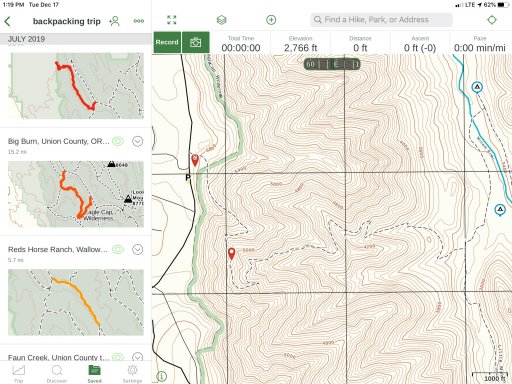
Smart phone running GAIA. I used my iPhone with GAIA last summer for a 4 day backpacking trip. Just download off line maps for the area you plan to go and no need for cell service. If you have an android device, I really like Back Country Navigator Pro As well.
 

LtShorty

Rank I
Launch Member

Traveler I

233
Cañon City, CO, USA
First Name
Mike
Last Name
Short
Member #

14811

So Im looking for a set up that will not only work in my car, but also for hiking and biking, so we are talking handheld essentially. What are some of the best options? My chief requirements will be durability, weather resistance, and quality of antennae (speed of acquisition is nice, but more Im looking for the ability to keep a signal with cloud or tree cover).
Also to add, the ability to upload maps is nice but really not required. Im not an epic adventure type so the maps I would need to upload would be smallish, maybe a 100 mile area. Im a fan of paper maps so really to me GPS is just a tool to locate my position on a map faster. I can triangulate with a compass but Im lazy, lol.
Gaia is the best my friend! It is so easy to use on all your devices. you can get discount subscriptions from the Overland community. I use Avenza also because many IMT teams use for Wildland fires and all risk incidents. Still no replacement for paper maps for the obvious, dead battery,bad coverage, and reliability.
 

Dilldog

Rank V
Launch Member
Investor

Influencer I

2,358
Spokane, WA.
First Name
Dillon
Last Name
Wilke
Member #

20298

Ham/GMRS Callsign
KJ7LVO/ WRQL275
Service Branch
USAF
So my big concern with Gaia is keeping a signal and durability. I don't want to put my phone on a set of handle bars, or rely on my phones antennae.
 
  • Like
Reactions: LtShorty

Plasmajab

Rank IV

Off-Road Ranger I

937
Quinte West, Ontario, Canada
First Name
Ian
Last Name
Howard
Ham/GMRS Callsign
VA3IRA
I use the garmin etrex touch 25.. Relatively cheap, runs on a pair of AA's, waterpoof. Works. Can be updated. Actually has some sports modes in it and there are bicycle mounts for it. Never used it on a bicicle myself but.


The bike mount


1Louder

Rank VI
Launch Member

Member II

4,187
AZ
First Name
Chris
Last Name
K
Member #

1437

Ham/GMRS Callsign
K1LDR
So my big concern with Gaia is keeping a signal and durability. I don't want to put my phone on a set of handle bars, or rely on my phones antennae.
Plenty or rugged cases available. A good RAM mount or similar and carry a battery pack. DUN done.

I don't think there are small handhelds which will provide you with as much flexibility as a phone app like Gaia GPS. I have never had GPS signal issues with my phone or tablet. Could it happen? Of course but I think these days that is pretty rare. If you have an iPhone you can be in airplane mode and the GPS will still work. I believe the same applies to Android. Otherwise look at what Garmin offers. I think it is pretty easy to read the specs and or watch a few reviews to see if something will work for you. I don't think most of those types of handhelds are map uploading friendly. But since I don't own one I can't speak intelligently to that. An app like Gaia GPS has tons of different map options. Especially if you are a premium member. You can get a discount through my link or others if you prefer. gaiagps.com/4xoa
 
  • Like
Reactions: LtShorty

M Rose

Local Expert
Mod Team
Member

Advocate III

5,584
Northeast Oregon, United States
First Name
Michael
Last Name
Rose
Member #

20990

Ham/GMRS Callsign
W7FSB
Service Branch
US ARMY Retired
On my 4 day backpacking trip last July, we lost cell signal about 3 miles before the trail head, and didn’t have cell service the whole trip. My iPhone running Gaia worked flawlessly.
 

Attachments

LtShorty

Rank I
Launch Member

Traveler I

233
Cañon City, CO, USA
First Name
Mike
Last Name
Short
Member #

14811

So my big concern with Gaia is keeping a signal and durability. I don't want to put my phone on a set of handle bars, or rely on my phones antennae.
Can I use my phone as a GPS without service?
The GPS feature in the iPhone can be used to find your location without a Wi-Fi or cellular connection. This process will allow you to takeyour maps offline giving you fast access to maps anytime. It allows you to avoid data roaming charges when traveling abroad and use GPS tracking without a service of any kind.
If you don’t want to use your phone Buy a cheap Garmin etrac I’ve been twice to Alaska on motorcycle (Prudhoe bay) and I have had good luck with both. Every McDonald’s in the world has Wi-Fi to download Maps. This is handy for different legs of your trip. I’ve also been in Mexico On the bike. You just need to plan ahead and download the Maps. Don’t forget to have some paper back ups. You can private message me and I’ll give you my number to help more.
 

Wawa Skittletits

Local Expert East Region USA
Staff member
Launch Member
Member

Expedition Master I

5,079
Wilkes-Barre, PA, USA
First Name
Drew
Last Name
Hawley
Member #

1537

Ham/GMRS Callsign
WRBZ674
Service Branch
USN veteran
Just a reminder since most don’t know and others may have forgotten that OB gets the best discount I’ve seen on Gaia.

 
  • Like
Reactions: Rubyredfozzy

Dilldog

Rank V
Launch Member
Investor

Influencer I

2,358
Spokane, WA.
First Name
Dillon
Last Name
Wilke
Member #

20298

Ham/GMRS Callsign
KJ7LVO/ WRQL275
Service Branch
USAF
Cool thanks for the input guys. Next question how much memory is required for Gaia if I do go that way? I could see myself running something like Gaia for the car, but its a 100% no on my bikes and hiking and such. I tend to try stuff I dont always have any business trying if you get my meaning. I have a few cracked helmets from my mountain biking escapades and I have had to use an ice axe to self arrest more than once, hence I just dont trust a phone either on handle bars or in an exterior pocket of a pack to hold up should I do something I really shouldnt, lol.
Also I do always carry paper maps and a compass, and honestly I would be fine with a GPS that only give lat. long. but you know I like looking at maps so a screen with a map is nice for wasting time in camp, lol.
 

LtShorty

Rank I
Launch Member

Traveler I

233
Cañon City, CO, USA
First Name
Mike
Last Name
Short
Member #

14811

Cool thanks for the input guys. Next question how much memory is required for Gaia if I do go that way? I could see myself running something like Gaia for the car, but its a 100% no on my bikes and hiking and such. I tend to try stuff I dont always have any business trying if you get my meaning. I have a few cracked helmets from my mountain biking escapades and I have had to use an ice axe to self arrest more than once, hence I just dont trust a phone either on handle bars or in an exterior pocket of a pack to hold up should I do something I really shouldnt, lol.
Also I do always carry paper maps and a compass, and honestly I would be fine with a GPS that only give lat. long. but you know I like looking at maps so a screen with a map is nice for wasting time in camp, lol.
I use my Garmen instinct wrist watch for lat/long and put my phone in my pack while on the motorcycle or mountain bike. I can always stop and take a peek at my phone at a cross trail. I have used my phone to track back to find an elk that I left in the dark timber the night before. There are many options out there for navigation. Good luck and safe travels!
 

M Rose

Local Expert
Mod Team
Member

Advocate III

5,584
Northeast Oregon, United States
First Name
Michael
Last Name
Rose
Member #

20990

Ham/GMRS Callsign
W7FSB
Service Branch
US ARMY Retired
Cool thanks for the input guys. Next question how much memory is required for Gaia if I do go that way? I could see myself running something like Gaia for the car, but its a 100% no on my bikes and hiking and such. I tend to try stuff I dont always have any business trying if you get my meaning. I have a few cracked helmets from my mountain biking escapades and I have had to use an ice axe to self arrest more than once, hence I just dont trust a phone either on handle bars or in an exterior pocket of a pack to hold up should I do something I really shouldnt, lol.
Also I do always carry paper maps and a compass, and honestly I would be fine with a GPS that only give lat. long. but you know I like looking at maps so a screen with a map is nice for wasting time in camp, lol.
My Samsung Galaxy Tab 10.2 only has 8 gigs of memory, with Gaia, I only use 2 gigs Using max resolution.
 

Dilldog

Rank V
Launch Member
Investor

Influencer I

2,358
Spokane, WA.
First Name
Dillon
Last Name
Wilke
Member #

20298

Ham/GMRS Callsign
KJ7LVO/ WRQL275
Service Branch
USAF
Cool thats not too bad, my Samsung has 16 gigs, I would just need to move my music to an SD card and I would be good to go.
 

Flipper

Rank V
Launch Member

Member III

2,865
Florida
First Name
John
Last Name
F
Member #

5021

Garmin makes nice handheld units. The 78, Oregon, Colorado, 76. Some with the “T” suffix are pre loaded with topos. I have the 76CX, waterproof and floats. Runs both marine charts and topo software and interfaces with my boats electronics. I also run Gaia Premium in our vehicles on a iPad Air ll with the Garmin glo ll .
 

1Louder

Rank VI
Launch Member

Member II

4,187
AZ
First Name
Chris
Last Name
K
Member #

1437

Ham/GMRS Callsign
K1LDR
With Gaia and all other apps it depends on how many maps you want to pre-download. I would recommend nothing less than 64gb but it also depends on what else you have on your device. I’m using about 10gb of storage for Gaia on my phone right now.

I like the suggestion of using a GPS watch. If you don’t care about maps then any of the cheaper etrex would probably work.
 

rsweet

Rank V

Member III

2,298
Huntington Beach, CA, USA
First Name
Robert
Last Name
Sweet
Member #

17264

Ham/GMRS Callsign
KN6IHR
Recommend a Garmin Inreach mini. Pair it a device, iPad or iPhone. Cool thing is you can get text messages. Someone can always reach you.
 

kivo

Rank II
Launch Member

Member III

490
Geel, Belgium
First Name
Kid
Last Name
Van Ouytsel
Member #

3123

If to serve in your car as well, your phone probably is the best way to go. I use Garmin's GpsMap range since many years for hiking, but a that small screen (compared to smartphones) would not exactly be user friendly whilst driving a car.
The nowadays phone apps are great, but I still like/prefer a rugged dedicated device, and all of its features for hiking - maybe I'm just getting old...lol
 
Last edited:

Dilldog

Rank V
Launch Member
Investor

Influencer I

2,358
Spokane, WA.
First Name
Dillon
Last Name
Wilke
Member #

20298

Ham/GMRS Callsign
KJ7LVO/ WRQL275
Service Branch
USAF
The in car use would be intermittent and used off highway to more easily identify what trail Im on when referencing a map. When Im driving around and need directions I usually just use Google Maps and par it to my stereo. I checked out the ETrex from Garmin and I think that might be what will fit my bill. But I definitely like the idea of being to get emergency messages out with the InReach.
 

Rubyredfozzy

Rank VI
Launch Member

Benefactor

3,771
Fort Mitchell, AL, USA
First Name
Aaron
Last Name
Welch
Member #

9264

Just a reminder since most don’t know and others may have forgotten that OB gets the best discount I’ve seen on Gaia.

thanks for the reminder. I just downloaded the app on my phone and will do my iPad tomorrow. preparing for a trip in Georgia next week for work.
 
  • Like
Reactions: Wawa Skittletits