COBDR Route Timing for a July '22 Run

  • HTML tutorial

K9LTW

Rank IV
Member
Investor

Traveler III

1,210
Front Royal, VA
First Name
Casey
Last Name
Arnold
Member #

25765

My wife and I and our two four-legged psychos are taking three weeks to get away from Virginia and follow the COBDR S to N come July in our Sequoia. While winging it is half the adventure, due to taking the opportunity to visit friends living in Denver while we're out there, I kinda sorta have a schedule to keep. So...reaching out to the community to try and get an idea of timing/distances/number of nights from Four Corners to where the route crosses I-70. Or if it works out better, I can split off at Leadville, then simply return to Leadville to continue the route. Basically going to have to pick a weekend to see them...then work backwards from there to determine a start date!

I figure I have a max of 10 days on the route. 21 - 8 days (4 out/4 back) - 2 days with friends - 1 day off at home to unpack/decompress = 10. I don't expect it to take 10...but things happen, and I also don't intend to spend the entire trip in the driver's seat! Our, general, rule is to spend no more than 6 hours driving a day. Yes, driving is super enjoyable, but we want to have time to enjoy camp, as well as some short hikes (because we'll be wheezing up a storm with our sea-level red blood cells :grinning:) and exploring some of the towns along the way. I've seen Adventure Portal's great post on their trip, but...sheesh...they spent 6 nights out and that was only to near Leadville! Though it appears they did more than the route itself.

Any input/conversation would be greatly appreciated...and if you're willing to share a favorite campsite or three, I'm all ears!

If we get done with a day or two two spare, we may actually go do the Wyoming BDR-X loop. I'm, eagerly, awaiting experiences of anyone driving the WYBDR as we hope to do most/all of it next year in our Power Wagon with OVRLND camper top.
 
  • Like
Reactions: Neal A. Tew

Neal A. Tew

US Rocky Mountain Local Expert
Mod Team
Member
Member

Member III

3,817
Pueblo West, CO
First Name
Neal
Last Name
Tew
Member #

12384

Ham/GMRS Callsign
N1TEW
Casey,

Have you done many of the famous CO tracks in the past or is this your first trip?
 

K9LTW

Rank IV
Member
Investor

Traveler III

1,210
Front Royal, VA
First Name
Casey
Last Name
Arnold
Member #

25765

Hey, @Neal A. Tew

While I've BEEN to Colorado a couple times...this is the first overlanding trip. All my past trips (while in summer) were strictly pavement based getting from one place to the other...and taking an entire day to hike to the peak of Vail (we were staying in Avon) while locals ran right past us while we took...uh...frequent...breaks :smirk: I know the route skirts the southern half of the Alpine Loop...but given the timetable we have, I wasn't sure if the entire loop is feasible! I'm pretty sure the Adv Portal folks did the whole loop which would explain why it took them 7 days just to hit I-70.

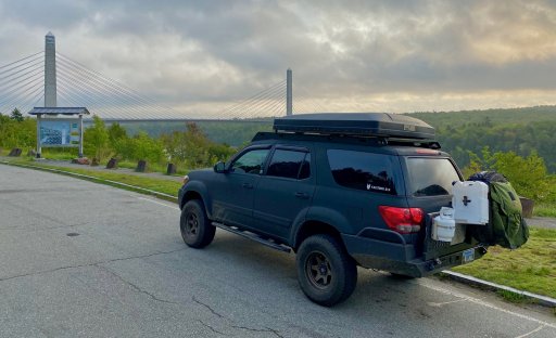
And we'll be running this old girl...
IMG_0080.jpg
 
  • Like
Reactions: Neal A. Tew

Neal A. Tew

US Rocky Mountain Local Expert
Mod Team
Member
Member

Member III

3,817
Pueblo West, CO
First Name
Neal
Last Name
Tew
Member #

12384

Ham/GMRS Callsign
N1TEW
Casey,

Keep in mind these traverse routes are often put together by bikers who have reason to avoid pavement other than just the fun of driving off-road. They are also trying to cover distance and connect legs together. As a result they often drive right by some of the best areas without stopping. My advice to you is to compile a list of the best 4WD tracks, hiking trails, etc and make those your priority. Let connecting the destinations via back roads be your secondary goal. I think you will see a lot more of the amazing stuff that is out here.

For example, I think doing the Alpine Loop (Engineer/Cinnamon Passes) without doing other nearby tracks is a travesty. I encourage you to seriously consider the following while in the area: Imogene Pass, Ophir Pass, Corkscrew Gulch, Hurricane Pass, California Pass, Yankee Boy Basin, Stony Pass etc. Then on your way to Leadville consider Tincup Pass, Hancock Pass, Mt. Antero, Mosquito Pass, etc. (Although this second group isn't quite the same caliber as the first group.)

I realize this is unsolicited advice and no hard feelings if you continue on. I've just seen this play out so many times.....
 

zgfiredude

Rank VI

Steward I

3,953
Silt, CO, USA
First Name
Brian
Last Name
Nichols
Member #

28938

Service Branch
Firefighter
Neal speaks the truth. If clicking off the BDR is the goal, that's fine. If you'd like to see more, and perhaps travel less, I think we can help. There is SO much here, and the BDR really is a path across the state, not necessarily through the best the state has to offer. It's up to you which you want to do....we're here to assist.

On a second note, I'm going to try some of the southern part of the Wyoming BDR in late May or June as soon as some of the snow clears out.
 
Last edited:

velo47

Rank VII
Launch Member

Member III

6,184
Albuquerque, NM, USA
First Name
Matt
Last Name
Harland
Member #

21731

Ham/GMRS Callsign
W3TAX
While what Neal and Brian say is true, if you want to do the BDR track, our experience last year was as follows:
Day 1 - 4 corners to Alta Lake outside of Telluride.
Day 2 - Ophir, Corkscrew, California & Hurricane passes to Animas Forks.
Day 3 - Late start, Cinnamon Pass to Gunnison (kinda off the track but the motos needed a shower!)
Day 4 - Wuanita and Cumberland passes to Buena Vista (the motos did Hancock instead of Cumberland)
Day 5 - Weston and Hagerman passes to Ivanhoe Lake
Day 6 - Got to Gypsum (I70) midday, we had to divert through Basalt due to fires

We would have gotten to Gypsum on day 5 if we had gotten an earlier start on day 3 and not gone to Gunnison, and if the motos didn't do Hancock on day 4.

You can see my writeup of the trip for more info:

 
Last edited:

K9LTW

Rank IV
Member
Investor

Traveler III

1,210
Front Royal, VA
First Name
Casey
Last Name
Arnold
Member #

25765

@Neal A. Tew and @zgfiredude ...appreciate the insights and offers. We're familiar with the BDR model and have done both the MABDR and most of the NEBDR. We combined the NE and Appalachian Byway for a trip to Maine last September...primarily because finding interesting dirt routes out here on the East Coast is a bit harder :disappointed: So...the primary reason I planned to follow the COBDR was ease of travel where I knew it was 100% doable solo rolling in our rig. While it may not be the best CO has to offer...hell...it's ALL going to be incredible to us :laughing:

With that said...we're, certainly, not married to it! Just looking at Gaia is enough to make your head spin with the endless options and having zeeeeeeeero area knowledge, Google Earth only goes so far as to determine what's doable and whether or not the area is going to have me having to back up 2 miles when a wagon train comes the other way. Or making sure we actually end up in an area that's not devoid of flatish ground to camp. We love the driving aspect of it all...but, yes, plan to get out of the truck to explore whenever we can, within the limitations of oxygen (we plan to carry supplemental O2 with us as getting sick would suuuuuuuuuuuck). As an aside...we're both in great conditioning, as well as our dogs, I just realize the limitations of physiology and remember how hard we were sucking wind in Vail...hahaha! We typically like to be at camp by 4...5 at the latest...to enjoy the process. We're, usually, wheels up by 8 the next morning, if not earlier...particularly in July when the sun will be kickstarting our dogs' stomachs in the pre-dawn hours.

I'm 1,000% open to help with routing from those with ground knowledge! Like I said before...I just need an decent idea of timing/schedule to get to Denver so I can properly plan, request time off, etc. I'm the type that likes to have that route planned per day with the allowance that things happen and I'll get back on schedule tomorrow. Two of the best memories we have from our trip to Maine were from a single bridge being out in Green Mountain National Forest in VT. Faced with backtracking for hours to get back on the route when it was already 3:30, we opted to explore some dead end forest road and ended up staying at our favorite site to date at the end of the road...watching dozens of satellites with the naked eye streak across the night sky. Consequently we had to skip 90 miles of the planned route the next morning to get back on schedule (we had a lake house rental to get to), and ended up going through Springfield, VT where we found an incredible little coffee shop with Black River Falls right behind it where we spent a gorgeous hour soaking in the sun with the dogs.

We're also 1,001% open to any ideas that keeps crowds minimal. LOL. Trying to aim as much as we can to be on trail during the weekdays. And while I love some challenges...we WILL be solo, albeit with comms, a winch, requisite boards and recovery gear, but also need the truck to survive the couple thousand miles home :wink:

@velo47 ...appreciate the insight! Particularly related to the actual drive time on 4-wheels. Will revisit the maps with that in mind!
 

K9LTW

Rank IV
Member
Investor

Traveler III

1,210
Front Royal, VA
First Name
Casey
Last Name
Arnold
Member #

25765

@zgfiredude ...oh...and I'm SUPER excited to what you find along the WYBDR. Particularly with regards to how well a full-size will fit along it. At first glance it appears that the route sticks more to the plains than the mountains/woods...but a map and a short promo video only give so much ground truth! We'll have roughly 7-8 months or so to build out the bed area for our camper top and cannot WAIT to burn way too many dead dinosaurs to get out there and explore!
 
  • Like
Reactions: zgfiredude

zgfiredude

Rank VI

Steward I

3,953
Silt, CO, USA
First Name
Brian
Last Name
Nichols
Member #

28938

Service Branch
Firefighter
Throw out some rough dates/days of the week type info for where you''ll want to start/finish and we can perhaps offer some alternatives for you to consider. I'm sure Neal will chime in as well.
 

Neal A. Tew

US Rocky Mountain Local Expert
Mod Team
Member
Member

Member III

3,817
Pueblo West, CO
First Name
Neal
Last Name
Tew
Member #

12384

Ham/GMRS Callsign
N1TEW
  • Like
Reactions: K9LTW

Neal A. Tew

US Rocky Mountain Local Expert
Mod Team
Member
Member

Member III

3,817
Pueblo West, CO
First Name
Neal
Last Name
Tew
Member #

12384

Ham/GMRS Callsign
N1TEW
While what Neal and Brian say is true, if you want to do the BDR track, our experience last year was as follows:
Day 1 - 4 corners to Alta Lake outside of Telluride.
Day 2 - Ophir, Corkscrew, California & Hurricane passes to Animas Forks.
Day 3 - Late start, Cinnamon Pass to Gunnison (kinda off the track but the motos needed a shower!)
Day 4 - Wuanita and Cumberland passes to Buena Vista (the motos did Hancock instead of Cumberland)
Day 5 - Weston and Hagerman passes to Ivanhoe Lake
Day 6 - Got to Gypsum (I70) midday, we had to divert through Basalt due to fires

We would have gotten to Gypsum on day 5 if we had gotten an earlier start on day 3 and not gone to Gunnison, and if the motos didn't do Hancock on day 4.

You can see my writeup of the trip for more info:

I did Hancock last year in my full size stocker. I was glad when it was over. LOL Lot's of basketball sized rocks to roll around on.
 

velo47

Rank VII
Launch Member

Member III

6,184
Albuquerque, NM, USA
First Name
Matt
Last Name
Harland
Member #

21731

Ham/GMRS Callsign
W3TAX
I did Hancock last year in my full size stocker. I was glad when it was over. LOL Lot's of basketball sized rocks to roll around on.
Yeah, the motos said Hancock was pretty difficult. Glad we passed (ha ha, get it?) on that.
 

K9LTW

Rank IV
Member
Investor

Traveler III

1,210
Front Royal, VA
First Name
Casey
Last Name
Arnold
Member #

25765

This is a great resource for CO trail info:


Basic subscription is free. If you decide to do a pay membership use the discount code: OVERLANDBOUNDCREW for 10%.
Ha! I'm glad you reminded me that I actually have had the paid subscription to that app for a couple years now :tearsofjoy: It's all but useless out here, but I'll be sure to peruse it for our forays west!
 
  • Like
Reactions: Neal A. Tew

K9LTW

Rank IV
Member
Investor

Traveler III

1,210
Front Royal, VA
First Name
Casey
Last Name
Arnold
Member #

25765

I did Hancock last year in my full size stocker. I was glad when it was over. LOL Lot's of basketball sized rocks to roll around on.
I've read a few accounts on folks doing the COBDR, or just the area in general in full-sizes. Can it be done? Sure thing. But almost all of them had a statement along the lines of they wouldn't, readily, do it again. HA! With the number of switchbacks, and some narrow areas, I'll, happily, take our FAR more maneuverable Yota. I love my RAM...but I'll always have a more trail-friendly vehicle; particularly as things get tight REAL quick around here.
 

Neal A. Tew

US Rocky Mountain Local Expert
Mod Team
Member
Member

Member III

3,817
Pueblo West, CO
First Name
Neal
Last Name
Tew
Member #

12384

Ham/GMRS Callsign
N1TEW
I did Hancock last year in my full size stocker. I was glad when it was over. LOL Lot's of basketball sized rocks to roll around on.
I've read a few accounts on folks doing the COBDR, or just the area in general in full-sizes. Can it be done? Sure thing. But almost all of them had a statement along the lines of they wouldn't, readily, do it again. HA! With the number of switchbacks, and some narrow areas, I'll, happily, take our FAR more maneuverable Yota. I love my RAM...but I'll always have a more trail-friendly vehicle; particularly as things get tight REAL quick around here.
I take my Chevy on all sorts of trails. It really wasn't the size, but the lack of clearance that got me on Hancock.
 
  • Like
Reactions: velo47 and K9LTW

K9LTW

Rank IV
Member
Investor

Traveler III

1,210
Front Royal, VA
First Name
Casey
Last Name
Arnold
Member #

25765

Throw out some rough dates/days of the week type info for where you''ll want to start/finish and we can perhaps offer some alternatives for you to consider. I'm sure Neal will chime in as well.
Probably shooting for hitting the Denver area the evening of Fri 7/15 straight to a hotel near our friends' place. Fully intend to spend the whole day exploring, and hope to end up either in Leadville, or right along I-70 for an expeditious superslab trip to the hotel for a late evening check-in and shower. Thinking 5 days/4 nights of adventure time (so, official, kick-off Monday morning the 11th), and while I understand it's kind of in the middle of nowhere so far as the sights are concerned...we kinda dig the idea of starting at Four Corners Monument as a) I doubt we'll be back, and b) it's "cool" in that cheesy, touristy, "that's it?" kinda way that's interesting to do just once with the requisite "Ermahgerd I'm in four states at once!" picture. Though with that said...I'm not averse to skipping it and starting in Durango if the general consensus is it's really, REALLY, not that worth it :tearsofjoy: Which all means we'll leave our place the preceding Thursday and travel through the weekend. Given the 30ish hours of travel, I limit my dogs to 8 hours in their crates...hence the planned four days.

Honestly, depending on the schedule, I wouldn't mind finishing around where the COBDR does as we may want to do a bit of exploring into WY for a day. But, certainly, not a requirement. From the, admittedly limited, intel I've read/heard, it seems the majority of major wow factor tends to be south of I70?

We'll have a fridge, stove, 5-lb propane tank, ability to carry 4 gal water + 2-3x 100L bladders, and 4 gal spare fuel. I do make it a point to top off pretty much any time we hit civilization (both fuel and water), and I understand that we won't be in no-man's land. Fully intend to spend those four+ nights on the roof using three nights in Denver to be clean and wash clothes...right back at it early the following Monday!

As far as routing...I'm 110% of the mindset that on a scale of 1(ugh) to 5 (DAAAAAAAAAAAMN!) I'll take a 3 and no people over a 5 and crowds/constantly having to find a spot to pull over. Always.
 

armyRN

Rank V
Launch Member

Member III

1,683
Longview, WA
First Name
Paul
Last Name
Dickinson
Member #

22047

Ham/GMRS Callsign
KI7TSP
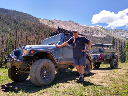
I too am thinking of doing the COBDR this summer (August). I spent some time in CO going south to north on the TAT last summer. Neal escorted us on some trails out there - Thanks again Neal!

So I've got a Jeep and small trailer. Does any of the COBDR have trailer restrictions? If so, are there bypasses?

TAT.2.png
 

velo47

Rank VII
Launch Member

Member III

6,184
Albuquerque, NM, USA
First Name
Matt
Last Name
Harland
Member #

21731

Ham/GMRS Callsign
W3TAX
We did the whole thing last year in a Jeep TJ with a small trailer (and a van and 4 motos). No issues other than a couple backups on the switchbacks on the San Juan passes.