Best Budget/Used Nav System for Beginner

  • HTML tutorial

Graeman

Rank V
Launch Member

Off-Road Ranger I

2,876
Catalina Avenue, Tucson, AZ, USA
First Name
Todd
Last Name
Hoffmaster
Member #

4284

Ham/GMRS Callsign
KJ7CRJ
Service Branch
Air Force
All 3 vehicles had the same issues when we were next to Mexico. The maps ran slow and stayed blurry while in the border towns.
 

1Louder

Rank VI
Launch Member

Member II

4,187
AZ
First Name
Chris
Last Name
K
Member #

1437

Ham/GMRS Callsign
K1LDR
All 3 vehicles had the same issues when we were next to Mexico. The maps ran slow and stayed blurry while in the border towns.
It sounds like the maps weren't downloaded or downloaded properly. If you have a premium subscription and are using layers if you have have this issue reduce each layer to zero to see if that clears things up. There is no reason for Gaia to have an issue with any area unless the map layer wasn't downloaded. Do you have Gaia running on 3 different devices or are you saying you had the issue as you switched vehicles? Reach out to Gaia support if you have any continued issues. That is always the best way to resolve an issue.
 

Graeman

Rank V
Launch Member

Off-Road Ranger I

2,876
Catalina Avenue, Tucson, AZ, USA
First Name
Todd
Last Name
Hoffmaster
Member #

4284

Ham/GMRS Callsign
KJ7CRJ
Service Branch
Air Force
It sounds like the maps weren't downloaded or downloaded properly. If you have a premium subscription and are using layers if you have have this issue reduce each layer to zero to see if that clears things up. There is no reason for Gaia to have an issue with any area unless the map layer wasn't downloaded. Do you have Gaia running on 3 different devices or are you saying you had the issue as you switched vehicles? Reach out to Gaia support if you have any continued issues. That is always the best way to resolve an issue.
No, I am saying that all three of us had the same issue at the border.
 

1Louder

Rank VI
Launch Member

Member II

4,187
AZ
First Name
Chris
Last Name
K
Member #

1437

Ham/GMRS Callsign
K1LDR
No, I am saying that all three of us had the same issue at the border.
Ok, I am not Gaia support but if you contacted them they would ask you what map layers you were running. What area did you download? Were you running multiple layers at the time. If you experience that again my suggestion would be to take a screen shot showing the issue and another showing the layers you are trying to display.
 

Graeman

Rank V
Launch Member

Off-Road Ranger I

2,876
Catalina Avenue, Tucson, AZ, USA
First Name
Todd
Last Name
Hoffmaster
Member #

4284

Ham/GMRS Callsign
KJ7CRJ
Service Branch
Air Force
Sorry I am just not a Gaia fan. It needs to be better. If I have to preload a map just to use it - does that make it the best. Nope. Can’t go anywhere on a whim since it doesn’t have the ability to be useful without the preload. Garmin handheld is the best by far.
 
  • Like
Reactions: Charles M

Graeman

Rank V
Launch Member

Off-Road Ranger I

2,876
Catalina Avenue, Tucson, AZ, USA
First Name
Todd
Last Name
Hoffmaster
Member #

4284

Ham/GMRS Callsign
KJ7CRJ
Service Branch
Air Force
Ok, I am not Gaia support but if you contacted them they would ask you what map layers you were running. What area did you download? Were you running multiple layers at the time. If you experience that again my suggestion would be to take a screen shot showing the issue and another showing the layers you are trying to display.
I don’t run multiple layers just natgeo only
 

1Louder

Rank VI
Launch Member

Member II

4,187
AZ
First Name
Chris
Last Name
K
Member #

1437

Ham/GMRS Callsign
K1LDR
Sorry I am just not a Gaia fan. It needs to be better. If I have to preload a map just to use it - does that make it the best. Nope. Can’t go anywhere on a whim since it doesn’t have the ability to be useful without the preload. Garmin handheld is the best by far.

Your opinion on what’s best and that’s cool. My opinion is dedicated devices turn into useless bricks. Neither one of us is right or wrong. Every app out there requires users to download maps for offline use.

I have done plenty of whim trips with Gaia and been able to download maps using my phone as a hotspot, or free WiFi from McDonald’s etc. I then had current maps for the area I needed and was off to go have fun. The same can be said for other tablet and phone based apps.

I find the map layers in Garmin devices to not be very useful. That’s me. 90% of the time I would be fine with only a paper map as a backup. It’s nice to have choices.

As for your issue on the border with Gaia I wasn’t there and can’t really determine if that was user error or a Gaia error. You mentioned you only run NatGeo maps. If you mean National Geographic maps then that could have been your issue. They are not offered everywhere and are very specific. Gaia Road abs Gaia Topo would be the most basic maps with the largest coverage.

That’s not really that important though. Go with what you feel is best

There is no coverage for NatGeo along the border in AZ. Here’s a screenshot from my phone.
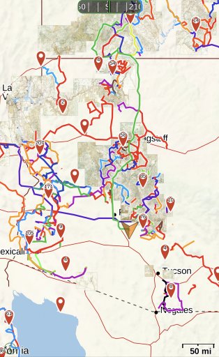
F435EEF5-D4B5-4DC7-BE97-709061111AD5.jpeg
 
Last edited:
  • Like
Reactions: Downs

systemdelete

Rank V
Launch Member

Pathfinder I

1,798
Nashville, TN
First Name
Erik
Last Name
Rumbaugh
Member #

13761

Sorry I am just not a Gaia fan. It needs to be better. If I have to preload a map just to use it - does that make it the best. Nope. Can’t go anywhere on a whim since it doesn’t have the ability to be useful without the preload. Garmin handheld is the best by far.
I have an IPad mini, with several different hi-res layers of the eastern half of the US and Canada pre downloaded in Gaia. I’d have to drive for around 3 days straight on pavement before I could get to the closest “edge” of my current map. Given a proper device with enough memory to predownload you can make your own Navigation unit that’s extremely capable. The user will need to put the time into familiarizing themselves with the software. You can mark key waypoints such as turns on a lower res map then transfer to a high res usgs or such for during travel. Or as mentioned earlier you can export the route to google or the like if you love their interface.
 
  • Like
Reactions: Downs and 1Louder

Connor_Dobbins

Rank V
Member

Explorer I

1,413
Northwest Chicago Suburb
First Name
Connor
Last Name
Dobbins
Member #

19373

Ham/GMRS Callsign
GMRS: WRHW455
@systemdelete @1Louder @Graeman All great information on the limitations of both Gaia and handheld devices! I knew Gaia didn't do turn by turn stuff but I didn't realize the Garmin handhelds were as capable as that. Honestly I think either will work for me because usually when I just use Google maps on the street I have the turn by turn sounds/voice off and just go by visual cues which would be similar to using Gaia. However, in an off-road environment I can see how the audible cues would help. Either way you all gave me a lot to think about and consider! Truthfully I'll probably get a handheld Garmin for at least a back up but on the first couple trips with it I'll probably use that along with Gaia on an old phone and see what I pay attention too more!

Speaking of turn by turn stuff with the handheld Garmin how do you set routes and stuff? Can you do it all from the device or do you need to do it from another device first?
 

Graeman

Rank V
Launch Member

Off-Road Ranger I

2,876
Catalina Avenue, Tucson, AZ, USA
First Name
Todd
Last Name
Hoffmaster
Member #

4284

Ham/GMRS Callsign
KJ7CRJ
Service Branch
Air Force
It can be only be done on the device. You can even set up how far in advance that it warns you, too.
 

CTO1Mike

Rank VI
Launch Member

Traveler II

3,858
Yuba City, CA
First Name
Michael
Last Name
Lester
Member #

19079

Ham/GMRS Callsign
KC5DWF
Service Branch
Navy
@systemdelete @1Louder @Graeman

Speaking of turn by turn stuff with the handheld Garmin how do you set routes and stuff? Can you do it all from the device or do you need to do it from another device first?
Garmin has a website where you can create routes, at least for the Inreach devices. Not very sure about thier other gps devices.
Once you create the route, you connect your Inreach via a supplied USB cable and update your device with the route and other things.
 
  • Like
Reactions: Graeman

Wanderer

Rank III
Launch Member

Enthusiast III

646
Carlsb CA
First Name
Ralph
Last Name
Jeffery
Member #

14615

But don’t you have to have cell service? I was using google maps on a camping trip in the redwoods. No cell service no maps no tracking. So you have to preload the maps. This to me is a problem because We started around Gualala and ended up in Oregon. That’s most of north California and some of southern Oregon. Which is way more than the 100,000 tile limit on Gaia at a decent scale 1:24000. This to me is the argument in favor of a dedicated gps with preloaded detailed maps like an older lowrance
 
  • Like
Reactions: Graeman

1Louder

Rank VI
Launch Member

Member II

4,187
AZ
First Name
Chris
Last Name
K
Member #

1437

Ham/GMRS Callsign
K1LDR
But don’t you have to have cell service? I was using google maps on a camping trip in the redwoods. No cell service no maps no tracking. So you have to preload the maps. This to me is a problem because We started around Gualala and ended up in Oregon. That’s most of north California and some of southern Oregon. Which is way more than the 100,000 tile limit on Gaia at a decent scale 1:24000. This to me is the argument in favor of a dedicated gps with preloaded detailed maps like an older lowrance
You can download more the 100,000 tiles but they have to be seperate downloads. If your downloads overland when drawn Gaia will stitch things together and no download duplicate data.

You can buy a dedicated device with limited pre-loaded maps. Or you can buy an app like Gaia and have a wealth of different map layers. Many with much greater detail. I prefer the later but everyone has different needs. No smartphone/tablet app will come with preloaded maps.

As a simple backup to Google Maps or Apple maps which generally required a data connection. you can use an app like Maps.me or Pocket Earth and easily download entire states with basic maps.
 

CTO1Mike

Rank VI
Launch Member

Traveler II

3,858
Yuba City, CA
First Name
Michael
Last Name
Lester
Member #

19079

Ham/GMRS Callsign
KC5DWF
Service Branch
Navy
But don’t you have to have cell service? I was using google maps on a camping trip in the redwoods. No cell service no maps no tracking. So you have to preload the maps. This to me is a problem because We started around Gualala and ended up in Oregon. That’s most of north California and some of southern Oregon. Which is way more than the 100,000 tile limit on Gaia at a decent scale 1:24000. This to me is the argument in favor of a dedicated gps with preloaded detailed maps like an older lowrance
There are gives and takes with all systems.

I preloaded 5 map layers to my Gaia running on a 32GB iPad for my run to Rally Sierras from north of Sacramento. I also have 5 map layers loaded for the Stonyford trail clean up. Still have plenty of room for more maps. My iPhone has 256GB. I think the largest map layer was 350 MegaBites. Again, Gaia on a cell enabled iPad will not need cell service in order to find and track it's possition. If I run out of room I can always delete the maps I no longer need and War Drive till I find a public wifi hot spot to down load new maps. If room is still an issue, try tayloring the maps to download only 5 miles to either side of your track. With a little planning, preloading maps in Gaia will cover just about all situations.

Side note, Google Maps does not preload maps and relies solely on cell data to down load the portion of the map it needs to display.
With preloaded map layers, Gaia does not rely on cell data at all.
 
  • Like
Reactions: Wallygator

Downs

Rank V
Launch Member

Member III

2,827
Hunt County Texas
First Name
Joshua
Last Name
Downs
Member #

20468

Ham/GMRS Callsign
KK6RBI / WQYH678
Service Branch
USMC 03-16, FIRE/EMS
But don’t you have to have cell service? I was using google maps on a camping trip in the redwoods. No cell service no maps no tracking. So you have to preload the maps. This to me is a problem because We started around Gualala and ended up in Oregon. That’s most of north California and some of southern Oregon. Which is way more than the 100,000 tile limit on Gaia at a decent scale 1:24000. This to me is the argument in favor of a dedicated gps with preloaded detailed maps like an older lowrance
You can download offline maps on google maps, I've downloaded half the state of Texas, half of Oklahoma, and all of Arkansas, as long as you have space you can download whatever you want. I always do this prior to a trip as well as download tiles for backcountry nav on my tablet. I used to be a standalone GPS kind of guy and started using my phone for primary navigation and never looked back. Less crap to carry around and keep updated.
 

Wanderer

Rank III
Launch Member

Enthusiast III

646
Carlsb CA
First Name
Ralph
Last Name
Jeffery
Member #

14615

Yes but from what I understand the best scale you can get on Gaia is 1:48000 or about 1”= 4000 feet which is a 15 min quad not a7.5 minute quad . the scale is actually 4 Xs. As large 2 x vertically 2xs horizontally

On My Lenovo tablet I used a 128gig micro card for storage. Loaded large areas at a zoom level 15. And used most of the card up. Only to find that these large areas were like 350,000 tiles . I thought it was fine then on a trial run found I couldn’t zoom in more than a about a level 9 sometimes up to level 12.
I admit this stuff is not my forte I have always used usgs paper maps 7.5 minutes for work.

I am totally unclear on how a zoom level 15 relates to scales
I don’t know for sure but think that larger scale limits the detail. Zoom level you can get
 

Graeman

Rank V
Launch Member

Off-Road Ranger I

2,876
Catalina Avenue, Tucson, AZ, USA
First Name
Todd
Last Name
Hoffmaster
Member #

4284

Ham/GMRS Callsign
KJ7CRJ
Service Branch
Air Force
My Garmin has a 1:24,000 map of the southwest and the map is so much clearer. Today I did a trail with the Gaia and Garmin. Much more detail, clear easy to read map. Yes, I had the area downloaded on gaia yesterday before I did the trails.
 

1Louder

Rank VI
Launch Member

Member II

4,187
AZ
First Name
Chris
Last Name
K
Member #

1437

Ham/GMRS Callsign
K1LDR
My Garmin has a 1:24,000 map of the southwest and the map is so much clearer. Today I did a trail with the Gaia and Garmin. Much more detail, clear easy to read map. Yes, I had the area downloaded on gaia yesterday before I did the trails.
Pictures comparing the two would help. Along with what map layers you were using.

I have never had an issue with maps being clear on Gaia unless there was an issue with the map download. That has been a very rare occurrence. The only other comparison I have is topo maps which come with the InReach with the Earthmate software. While the maps work they are no where near as detailed.

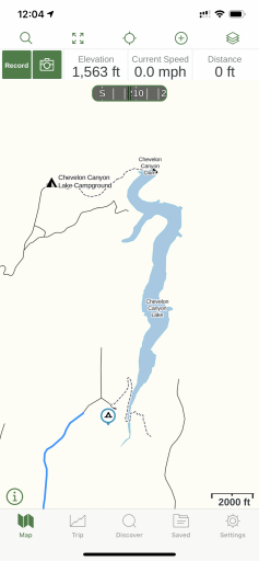
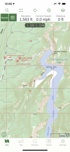
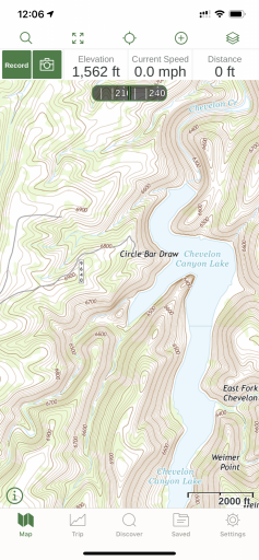
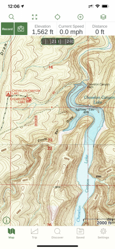
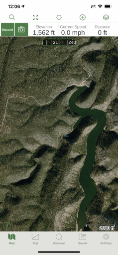
Here are some examples of different map layers on my iPhone. I could have zoomed in further but you wouldn't be able to tell what the area was. I also have Google road and Satellite as custom map layers in Gaia GPS.

81CEEAC3-7D6C-4D7D-AC5D-D1115EF8FA55.png
Gaia basic topo


C8DB36F3-932A-453A-953A-52757A74F369.png
USFS 2016

027709A4-0D08-4516-A6C2-A647BA83E09B.png
US topo

0EACA793-E1F4-458A-B278-3DA4D2C365A3.png
USGS Topo

39C8AACD-E931-431D-894C-E1E3A398B8D2.png
ESRI Premium Satellite Layer
 
Last edited:
  • Like
Reactions: OXGX and CTO1Mike