Member III
Another option for sending a message from a remote location without cell service is APRS via satellite. Sure a sat phone or spot or such would be better using a geo sat.... but if you don't have one and just need to send general info (non-emergency) this works too and it's kind of fun for the #radionerd like me.
The path and frequency are different for satellite than for terrestrial APRS.
Frequency: 145.825MHz
Path: ARISS
If you aren't familiar with how to send SMS/Email messages by APRS refer here: OB Approved - SMS Text and Email via APRS
You can work the APRS sats with a mobile radio setup pushing about 30 watts however a hendheld directional (yagi) antenna would make it better to hit those low elevation passes. With a handheld yagi antenna you can also use a handheld radio and send a packet with less watts.
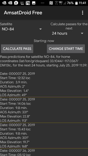
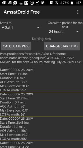
How do you know when a satellite is going to fly over? Welll... that can be a bit tricky as without cell service you won't be able to use a satellite tracking app. (AmsatDroid works offline, per BagiMT below)
However, using sites like amsat.org you can view the pass predictions for the various satellites and note the time of the best passes.
With there being at least 3 maybe 4 APRS Sats right now you are likely to get a couple good passes a day.
Right now the most commonly used APRS Sats are AiSat-1, PSat2, ISS (when APRS is operational), and NO-84.
PSat2 is a new Sat and is on such a path that it come across at almost the same time every day, minus a few minutes. Due to it's path it is really only accessible by those in lower US states/Central America (and other countries along the equator-mid latitudes.)
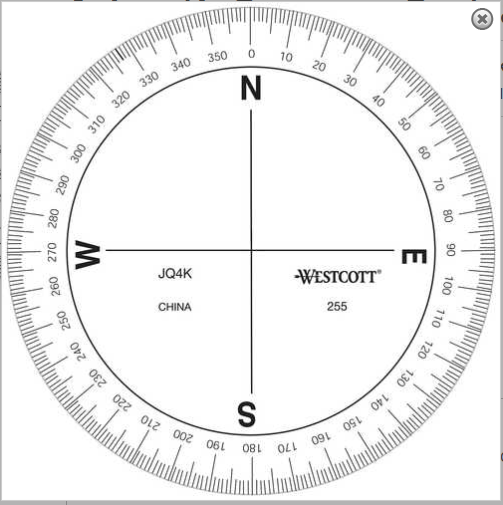
If working a satellite, it is also helpful to know the Azimuth (a degree representing a direction, 0° = North, 90° =E, 180° = S, etc) and an elevation. This helps determine if you are able to hit the repeater using your mobile setup (higher elevation is better though not necessarily directly overhead) or where to point your directional antenna. Sat tracking sites and apps give the Azimuth and elevation.

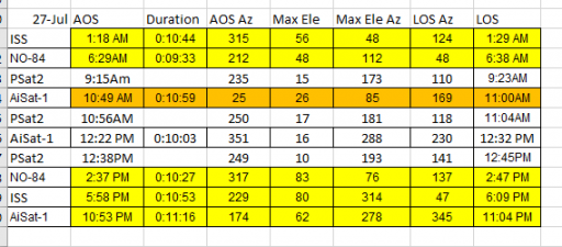
If I was planning on staying in the Ouachita National Forest in Oklahoma on 7/27/2019 here are my available passes that I might be able to hit. There are MANY more passes but I picked out the higher elevation passes that I could hit with my mobile or possibly with a yagi. Yellow are good high passes, Orange are lower passes and white are really low. Orange may need a yagi, white would most definitely need a yagi.

Definitions:
AOS: Acquisition of Signal/Satellite
LOS: Loss of Signal/Satellite
Ele: Elevation
Az: Azimuth
Example: The AiSat-1 pass @ 10:49am with an AOS Azimuth of 25°
I should start hearing packets from the sat just after 10:49, the sat would be coming from the North, slightly NE (25°).
At the max elevation of 26° the sat would be above the eastern horizon and at LOS it would be at 169°, almost directly south.
Example 2: The ISS pass @ 5:58pm with an AOS Azimuth of 229°
I would start hearing packets from the sat just after 5:58, the sat would be coming from the SW.
At the max elevation of 80° the sat would be passing almost right over me slightly to the NW.
At LOS the sat would be to the NE.
You would want to do this from the highest point you could if you were in a hilly/mountainous area. The AOS and LOS times are for flat terrain.
I know 99.9% of the members here won't use this, but I thought at least those with the capability may be interested in it. Even if it is just to make a QSO. I would be willing to try it with anyone that is interested if we can line something up that works with my schedule and the satellite passes.
I have done this for no other reason than to prove that I could. I sent an SMS text message from the ham radio in my Jeep via APRS to the ISS, back down to earth to my wife's cell phone.
((It doesn't go directly to my wife's cell phone..... obviously. The packet gets picked up by an I-gate on earth and funneled to the APRS-IS (Internet service) where another program (SMSGTE) converts the packet to a SMS text message and puts it on the cell network. Works the same for a terrestrial SMS Message as well, your packet gets digipeater and hopefully picked up by an I-gate to the APRS-IS and on to SMSGTE, etc))
Let me know if you have any questions.
The path and frequency are different for satellite than for terrestrial APRS.
Frequency: 145.825MHz
Path: ARISS
If you aren't familiar with how to send SMS/Email messages by APRS refer here: OB Approved - SMS Text and Email via APRS
You can work the APRS sats with a mobile radio setup pushing about 30 watts however a hendheld directional (yagi) antenna would make it better to hit those low elevation passes. With a handheld yagi antenna you can also use a handheld radio and send a packet with less watts.
How do you know when a satellite is going to fly over? Welll... that can be a bit tricky as without cell service you won't be able to use a satellite tracking app. (AmsatDroid works offline, per BagiMT below)
However, using sites like amsat.org you can view the pass predictions for the various satellites and note the time of the best passes.
With there being at least 3 maybe 4 APRS Sats right now you are likely to get a couple good passes a day.
Right now the most commonly used APRS Sats are AiSat-1, PSat2, ISS (when APRS is operational), and NO-84.
PSat2 is a new Sat and is on such a path that it come across at almost the same time every day, minus a few minutes. Due to it's path it is really only accessible by those in lower US states/Central America (and other countries along the equator-mid latitudes.)
If working a satellite, it is also helpful to know the Azimuth (a degree representing a direction, 0° = North, 90° =E, 180° = S, etc) and an elevation. This helps determine if you are able to hit the repeater using your mobile setup (higher elevation is better though not necessarily directly overhead) or where to point your directional antenna. Sat tracking sites and apps give the Azimuth and elevation.

If I was planning on staying in the Ouachita National Forest in Oklahoma on 7/27/2019 here are my available passes that I might be able to hit. There are MANY more passes but I picked out the higher elevation passes that I could hit with my mobile or possibly with a yagi. Yellow are good high passes, Orange are lower passes and white are really low. Orange may need a yagi, white would most definitely need a yagi.

Definitions:
AOS: Acquisition of Signal/Satellite
LOS: Loss of Signal/Satellite
Ele: Elevation
Az: Azimuth
Example: The AiSat-1 pass @ 10:49am with an AOS Azimuth of 25°
I should start hearing packets from the sat just after 10:49, the sat would be coming from the North, slightly NE (25°).
At the max elevation of 26° the sat would be above the eastern horizon and at LOS it would be at 169°, almost directly south.
Example 2: The ISS pass @ 5:58pm with an AOS Azimuth of 229°
I would start hearing packets from the sat just after 5:58, the sat would be coming from the SW.
At the max elevation of 80° the sat would be passing almost right over me slightly to the NW.
At LOS the sat would be to the NE.
You would want to do this from the highest point you could if you were in a hilly/mountainous area. The AOS and LOS times are for flat terrain.
I know 99.9% of the members here won't use this, but I thought at least those with the capability may be interested in it. Even if it is just to make a QSO. I would be willing to try it with anyone that is interested if we can line something up that works with my schedule and the satellite passes.
I have done this for no other reason than to prove that I could. I sent an SMS text message from the ham radio in my Jeep via APRS to the ISS, back down to earth to my wife's cell phone.
((It doesn't go directly to my wife's cell phone..... obviously. The packet gets picked up by an I-gate on earth and funneled to the APRS-IS (Internet service) where another program (SMSGTE) converts the packet to a SMS text message and puts it on the cell network. Works the same for a terrestrial SMS Message as well, your packet gets digipeater and hopefully picked up by an I-gate to the APRS-IS and on to SMSGTE, etc))
Let me know if you have any questions.
Last edited:


