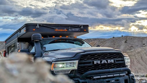
If you are in southern California and are interested in a 220 mile adventure that will last 4-6 days while showing you a little bit of everything the desert has to offer, then the Anza-Borrego Discovery Trial should be top on your list. This trail earned my respect as one of the few which requires you to constantly be on top of your game mentally. The open desert had me searching for roads during a sandstorm, the flat sandy washes kept me scanning to avoid soft wet spots, the rocky and rugged sections required me to navigate obstacles below me, and sometimes to the sides, or above, simultaneously. And since progress was slow and there were no major cities nearby, I was constantly recalculating fuel use and revising plans to exit the trail and refuel if necessary. After 4-1/2 days on the trail I decided to take a full day and just camp at a disbursed camping location in the desert to relax and recover.
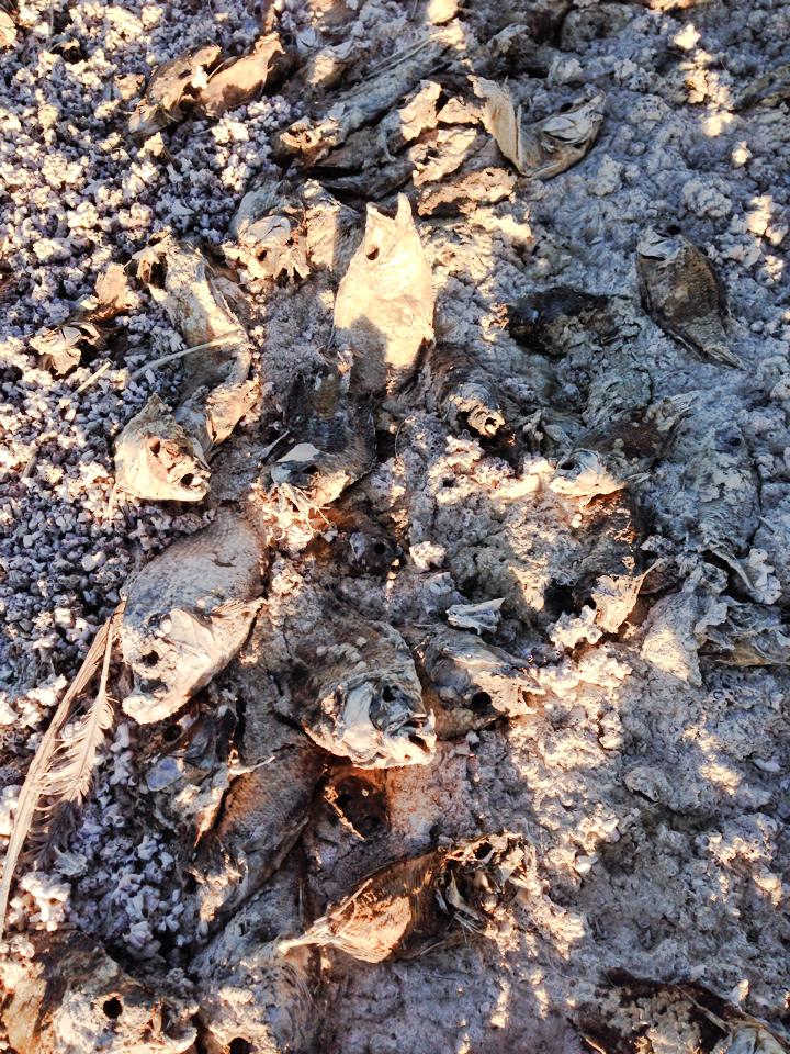
The nearby Salton Sea, deserves it's own story since it was "formed in the early 1900s after a dam broke and flooded the Imperial Valley with water from the Colorado River." For the past five or so decades the area has been transformed into a post-apocalyptic wasteland as residents fled, and the sea filled with "nearby farm runoff, which includes fertilizer, heavy metals and toxins like arsenic and selenium." Here is an awesome 17 minute video telling the story about California's Miracle in the Desert. Just a few hours more and I rolled into Ocotillo, disappeared into the desert, and my adventure began!
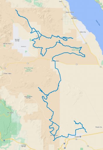
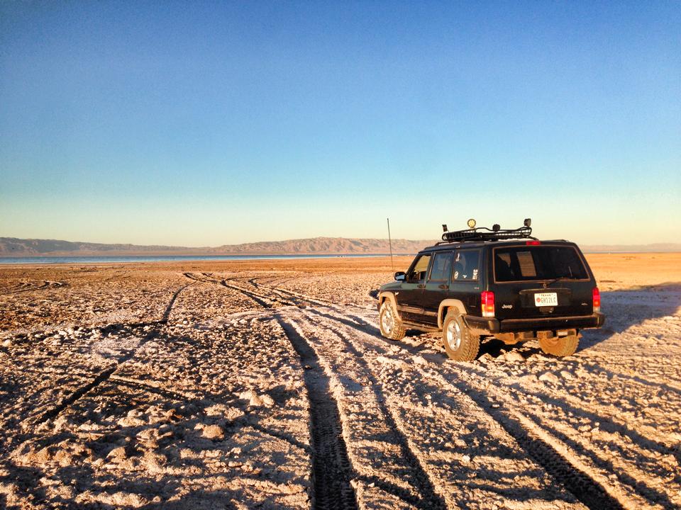
After initially traveling for a few hours in the dark I found a place to bed down for the night along an abandoned rail line that winds through Goat Canyon. It rained most of the night and although the sun shined brightly, the gusting winds reminded me that conditions will be rough over the next few days. The Anza-Borrego State Park is at the northern end of the Sonoran Desert and contains over 600,000 acres and contains "washes, badlands, slot canyons, mud palisades and palm oases." After I crawled through this area I parked atop a hill and could see for many miles in every direction. No man-made objects were visible, only nature.
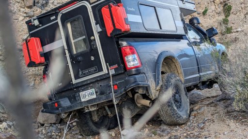
I took a break after successfully driving my AEV Prospector through the tight and twisty Piepkorn Slot and then played a bit at Diablo Drop Off. It is important to note that this trail is designed to be run from south to north since there are two one way sections, one of which is Diablo Drop Off. As you travel northbound, you will descend both drops so it is rather easy for most any 4x4 vehicle with a driver of average ability. Since it was during the week and no one else was using the area I wanted to test my ability to crawl up the 30° moguls which turned out to be rather easy.
One thing I really enjoyed about Anza-Borrego was the fact that as you move towards the north you pass through many different types of desert environments. Just hours ago I was in the mountains on rocky trails and now I find myself in washes with sandy bottoms and tall mud walls. Speaking of mud, I did take time to explore the Arroyo Tapiado Mud Caves although I urge you to be cautious since years ago a young man died in the them on Easter Sunday when the caves collapsed and trapped him.
Sandstone Canyon is reported to be one of the most photographed locations in the park so although it is an optional spur, I was unable to resist. This is a slot canyon that is unlike anything I have ever been able to drive into previously. This alone is worth the trip and as I drove through slowly I couldn't help stretching out my window and looking up. Although I was the only one in the canyon for the entire time I was there, I have read where this area becomes somewhat congested during the weekend. Maybe I'm selfish but I enjoyed having it all to myself for just a bit.

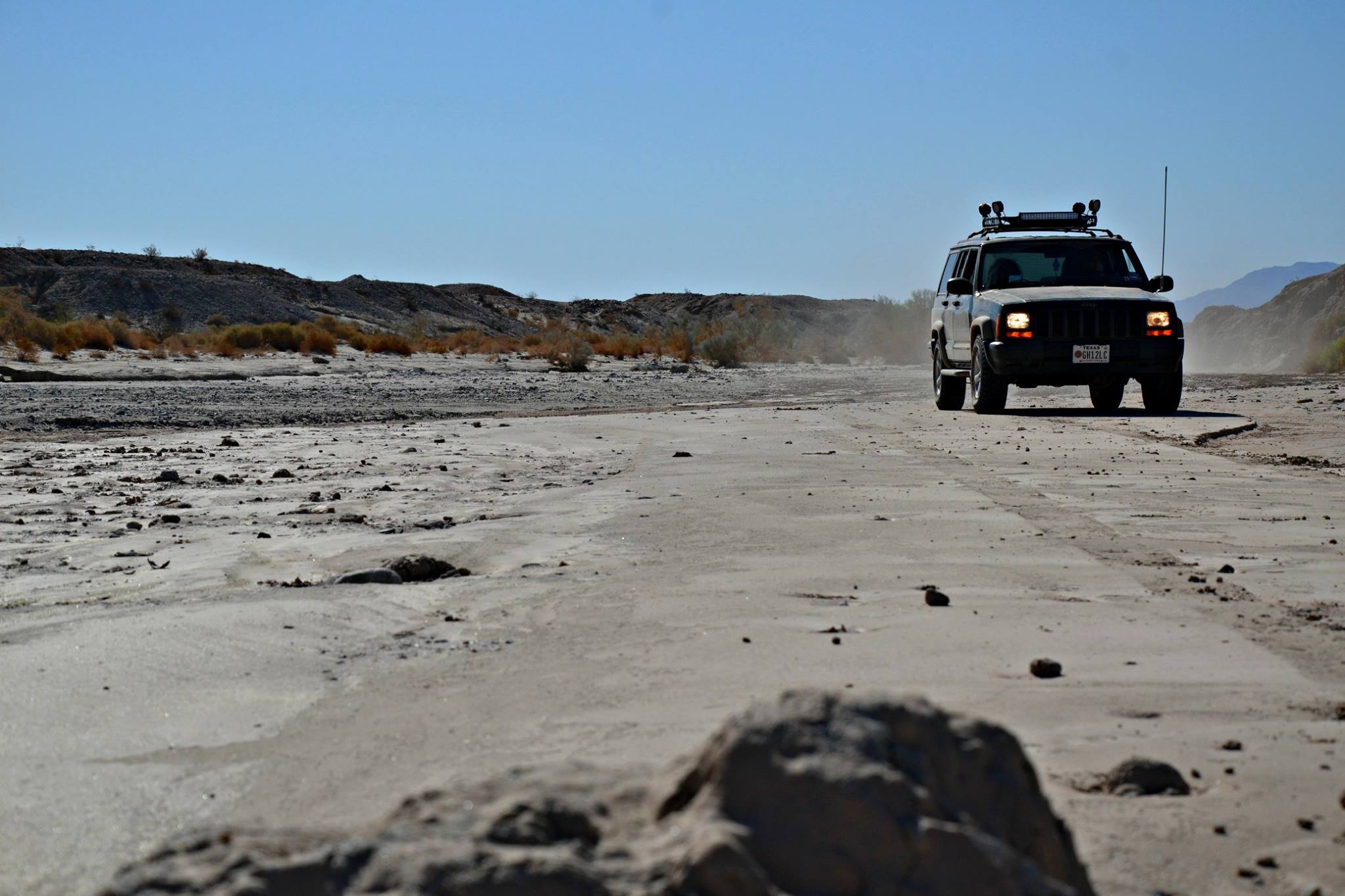
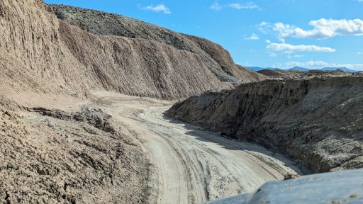
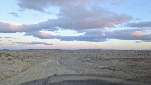
Part of my journey was on a trail that had been used since the 1700s and was later named the Great Overland Stage Route of 1849. Mark Twain described traveling along this route in a horse and carriage as "swinging and swaying cage" and "an imposing cradle on wheels." The section depicted below was hours north of the area described by Mr. Twain but as you can see it was flat and sandy for as far as my eyes were able to see. I found an area to bed down for the night between the Gas Domes and the Pumpkin Patch and woke up to a sandstorm. I drove for hours barely moving forward with my eyes straining to see what once was a road. Although Gaia GPS helped to keep me in the general area it was easy at times to wander off into the desert only to realize I was off the road.
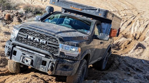
Here I am climbing up more rocky and narrow shelf roads that were in a somewhat tight and twisty section just north of Slot Canyon. I elected not to stop and hike the Slot Canyon since I plan to return to this location again at some point in the future. There were a few other memorable locations I skipped such as Wind Caves since I want to see these places for the first time when I return someday.
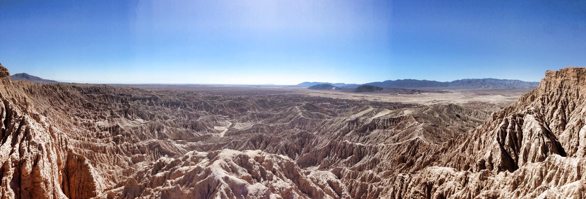
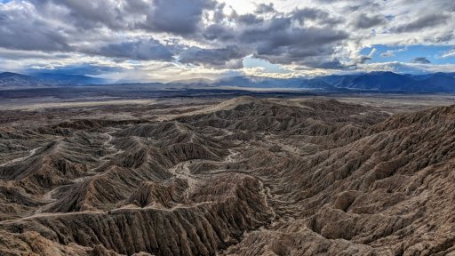
Earlier I mentioned that Sandstone Canyon was one of the most photographed locations in the park - well this is the most visited and photographed location: Fonts Point. "Fonts Point provides a spectacular 270 degree view of the badlands that surround it below. The badlands are especially impressive when as the sun rises from the east and sheds its light on the creases and crevices of barren landscape below." Next time I visit I plan to watch the sun rise, and set, at this very location. As I stood on the edge of the point I was speechless - it felt as if time stood still as I looked hundreds of feet below to the badlands.
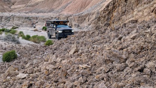
Here is an example of a 25+ foot mud wall that recently collapsed blocking the trail. After scouting the nearby area I located a safe go around. A day or two earlier, I encountered a massive chunk of a mud or rock wall that was larger than my vehicle and had broken off to block the trail. I guess the moral of the story is be prepared for the unexpected when passing trough areas such as this. A fallen tree or washed out shelf road back east is one thing, but mud slides and vehicle sized rocks blocking the trail are somewhat new to me.
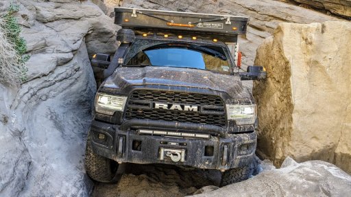
I figured I would save the money shot for the final picture in this report. This is me squeezing through an obstacle in Sandstone Canyon. Prior to attempting this I performed research and found many pictures and videos of Jeep and Toyotas passing through but I was unable to find any example of a full sized rig with a camper making it through. Yes, I it was necessary to fold my mirrors in for a bit and no, I was not able to open my doors more than a few inches once I was in there. After this picture was posted at another location, I discovered that there was another driver in a full size rig with a camper who has also squeezed through a year ago - I only wish I had know that going in since I would have felt a bit better knowing someone else has already successfully navigated this obstacle. Nonetheless, this was fun but I just can't express how much of a good time the overall adventure was. Happy trails!
The nearby Salton Sea, deserves it's own story since it was "formed in the early 1900s after a dam broke and flooded the Imperial Valley with water from the Colorado River." For the past five or so decades the area has been transformed into a post-apocalyptic wasteland as residents fled, and the sea filled with "nearby farm runoff, which includes fertilizer, heavy metals and toxins like arsenic and selenium." Here is an awesome 17 minute video telling the story about California's Miracle in the Desert. Just a few hours more and I rolled into Ocotillo, disappeared into the desert, and my adventure began!
After initially traveling for a few hours in the dark I found a place to bed down for the night along an abandoned rail line that winds through Goat Canyon. It rained most of the night and although the sun shined brightly, the gusting winds reminded me that conditions will be rough over the next few days. The Anza-Borrego State Park is at the northern end of the Sonoran Desert and contains over 600,000 acres and contains "washes, badlands, slot canyons, mud palisades and palm oases." After I crawled through this area I parked atop a hill and could see for many miles in every direction. No man-made objects were visible, only nature.
I took a break after successfully driving my AEV Prospector through the tight and twisty Piepkorn Slot and then played a bit at Diablo Drop Off. It is important to note that this trail is designed to be run from south to north since there are two one way sections, one of which is Diablo Drop Off. As you travel northbound, you will descend both drops so it is rather easy for most any 4x4 vehicle with a driver of average ability. Since it was during the week and no one else was using the area I wanted to test my ability to crawl up the 30° moguls which turned out to be rather easy.
One thing I really enjoyed about Anza-Borrego was the fact that as you move towards the north you pass through many different types of desert environments. Just hours ago I was in the mountains on rocky trails and now I find myself in washes with sandy bottoms and tall mud walls. Speaking of mud, I did take time to explore the Arroyo Tapiado Mud Caves although I urge you to be cautious since years ago a young man died in the them on Easter Sunday when the caves collapsed and trapped him.
Sandstone Canyon is reported to be one of the most photographed locations in the park so although it is an optional spur, I was unable to resist. This is a slot canyon that is unlike anything I have ever been able to drive into previously. This alone is worth the trip and as I drove through slowly I couldn't help stretching out my window and looking up. Although I was the only one in the canyon for the entire time I was there, I have read where this area becomes somewhat congested during the weekend. Maybe I'm selfish but I enjoyed having it all to myself for just a bit.
Part of my journey was on a trail that had been used since the 1700s and was later named the Great Overland Stage Route of 1849. Mark Twain described traveling along this route in a horse and carriage as "swinging and swaying cage" and "an imposing cradle on wheels." The section depicted below was hours north of the area described by Mr. Twain but as you can see it was flat and sandy for as far as my eyes were able to see. I found an area to bed down for the night between the Gas Domes and the Pumpkin Patch and woke up to a sandstorm. I drove for hours barely moving forward with my eyes straining to see what once was a road. Although Gaia GPS helped to keep me in the general area it was easy at times to wander off into the desert only to realize I was off the road.
Here I am climbing up more rocky and narrow shelf roads that were in a somewhat tight and twisty section just north of Slot Canyon. I elected not to stop and hike the Slot Canyon since I plan to return to this location again at some point in the future. There were a few other memorable locations I skipped such as Wind Caves since I want to see these places for the first time when I return someday.
Earlier I mentioned that Sandstone Canyon was one of the most photographed locations in the park - well this is the most visited and photographed location: Fonts Point. "Fonts Point provides a spectacular 270 degree view of the badlands that surround it below. The badlands are especially impressive when as the sun rises from the east and sheds its light on the creases and crevices of barren landscape below." Next time I visit I plan to watch the sun rise, and set, at this very location. As I stood on the edge of the point I was speechless - it felt as if time stood still as I looked hundreds of feet below to the badlands.
Here is an example of a 25+ foot mud wall that recently collapsed blocking the trail. After scouting the nearby area I located a safe go around. A day or two earlier, I encountered a massive chunk of a mud or rock wall that was larger than my vehicle and had broken off to block the trail. I guess the moral of the story is be prepared for the unexpected when passing trough areas such as this. A fallen tree or washed out shelf road back east is one thing, but mud slides and vehicle sized rocks blocking the trail are somewhat new to me.
I figured I would save the money shot for the final picture in this report. This is me squeezing through an obstacle in Sandstone Canyon. Prior to attempting this I performed research and found many pictures and videos of Jeep and Toyotas passing through but I was unable to find any example of a full sized rig with a camper making it through. Yes, I it was necessary to fold my mirrors in for a bit and no, I was not able to open my doors more than a few inches once I was in there. After this picture was posted at another location, I discovered that there was another driver in a full size rig with a camper who has also squeezed through a year ago - I only wish I had know that going in since I would have felt a bit better knowing someone else has already successfully navigated this obstacle. Nonetheless, this was fun but I just can't express how much of a good time the overall adventure was. Happy trails!