Benefactor
- 15,584
- First Name
- Michael
- Last Name
- Murguia
- Member #
-
0000
- Ham/GMRS Callsign
- KM6YSL
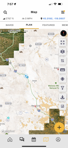
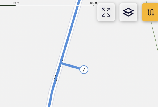
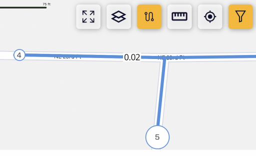
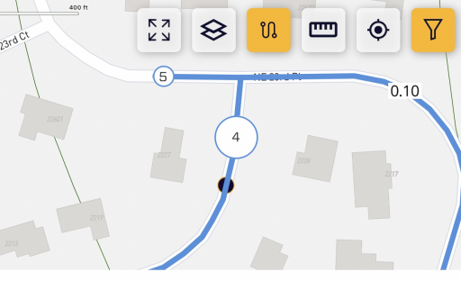
11.11.0 Ironhorse Release (@Firemom @Magic Mike ) - Route Planning with Route Snapping
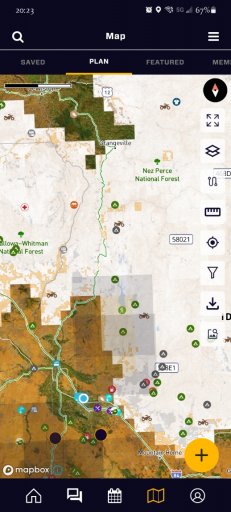
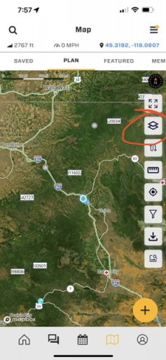
Overland Bound Members Mike and Deb aka Ironhorse Overland are full-time overlanders in their 4Runner. One of the must have features for Deb, and many overland travelers is route planning! Now we have it.
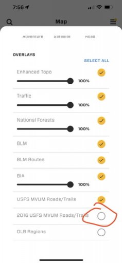
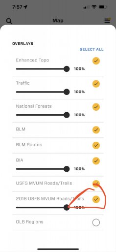
It wasn't enough to create just a route planner that snaps to the roads with multiple routing types, or to be able to change the color of your route for better visibility or organization, we also had to make routes shareable because Overland Bound is founded on community. Routes can also be exported as a GPX.
Release List:
Feature Route Planning
Feature Route sharing
Feature Save/Delete a route
Feature Add "never sleep" option to settings
Improvement Pop Up when selecting "Off-Road" routing mode - first time
Improvement Route Planning Intro Tutorial Pop-up
Improvement On Route Waypoint Edit, Show a Magnifying Glass
Improvement Route Planning: Ability to delete a waypoint that is in edit mode
Improvement Add waypoint numbers in route planner waypoints
Improvement Route line is under gpx tracks
Improvement Haptic vibrate on waypoint edit mode
Improvement Show waypoints on saved routes
Improvement Change Route banner color to blue
Improvement Edit Route Button
Improvement Disable share for quick saves
Improvement Share Route as GPX Button
Improvement Remove privacy for Routes - they are private by default
Improvement Privacy notification the first time a shared Route is opened by a user
Improvement Create "Delete Account" button in settings
Improvement Add Route Planning Icon to POI type
Improvement Filter Route location type client side to not show up in Add Location list
Improvement In the change color picker screen, change button text to “Change color”
Improvement Quick-Saves do not show saved trail color in Detail screen map
Improvement Clean up Map and GPX button spacing in POI location detail screens
Improvement Make the Route color swatch tappable to edit color
Improvement Allow app font icons to be used for information types
Improvement Disable (or hide) Reviews in Private Routes
TaskNew POI Location Type "Route"
Task Go Live: Marketing Website
Task Create Route Icon
Bug Bad Platform Redirect: Rally Point Announcement comments button
Bug w3w Lookup Crashing
Bug App is not "locking" conversations to replies on Rally Point invite conversations.
Bug Editing Rally Point Dates switches it to day of month rather than day of week.
Bug Dark mode mile and kilometer button font color
Bug Editing the start date of a rally point crashes the app iOS 15.5, Latest app ver
Bug fix default repeat mode when CREATING rally point
Bug Messages don't find user, event though they exist
Bug Sending message to user that is not found results in white screen
Bug Pasting a YouTube link hard crash in forums
Bug Opening the Member tab on the map crashes the app
Bug Tapping the Message Members button on the Member tab crashes app
Overland Bound Members Mike and Deb aka Ironhorse Overland are full-time overlanders in their 4Runner. One of the must have features for Deb, and many overland travelers is route planning! Now we have it.
It wasn't enough to create just a route planner that snaps to the roads with multiple routing types, or to be able to change the color of your route for better visibility or organization, we also had to make routes shareable because Overland Bound is founded on community. Routes can also be exported as a GPX.
Release List:
Feature Route Planning
Feature Route sharing
Feature Save/Delete a route
Feature Add "never sleep" option to settings
Improvement Pop Up when selecting "Off-Road" routing mode - first time
Improvement Route Planning Intro Tutorial Pop-up
Improvement On Route Waypoint Edit, Show a Magnifying Glass
Improvement Route Planning: Ability to delete a waypoint that is in edit mode
Improvement Add waypoint numbers in route planner waypoints
Improvement Route line is under gpx tracks
Improvement Haptic vibrate on waypoint edit mode
Improvement Show waypoints on saved routes
Improvement Change Route banner color to blue
Improvement Edit Route Button
Improvement Disable share for quick saves
Improvement Share Route as GPX Button
Improvement Remove privacy for Routes - they are private by default
Improvement Privacy notification the first time a shared Route is opened by a user
Improvement Create "Delete Account" button in settings
Improvement Add Route Planning Icon to POI type
Improvement Filter Route location type client side to not show up in Add Location list
Improvement In the change color picker screen, change button text to “Change color”
Improvement Quick-Saves do not show saved trail color in Detail screen map
Improvement Clean up Map and GPX button spacing in POI location detail screens
Improvement Make the Route color swatch tappable to edit color
Improvement Allow app font icons to be used for information types
Improvement Disable (or hide) Reviews in Private Routes
TaskNew POI Location Type "Route"
Task Go Live: Marketing Website
Task Create Route Icon
Bug Bad Platform Redirect: Rally Point Announcement comments button
Bug w3w Lookup Crashing
Bug App is not "locking" conversations to replies on Rally Point invite conversations.
Bug Editing Rally Point Dates switches it to day of month rather than day of week.
Bug Dark mode mile and kilometer button font color
Bug Editing the start date of a rally point crashes the app iOS 15.5, Latest app ver
Bug fix default repeat mode when CREATING rally point
Bug Messages don't find user, event though they exist
Bug Sending message to user that is not found results in white screen
Bug Pasting a YouTube link hard crash in forums
Bug Opening the Member tab on the map crashes the app
Bug Tapping the Message Members button on the Member tab crashes app