
All Going
Eldorado Range/Colorado River Overnight
-
START DATE
Saturday, December 19, 2020
10:00 AM Pacific Time (US & Canada)10:00 Hrs GMT -8:00 -
END DATE
Sunday, December 20, 2020
12:00 PM Pacific Time (US & Canada)12:00 Hrs GMT -8:00
 RALLY POINT EVENT
 OVERLAND BOUND REGION
US Southwest
 EVENT TYPE
Trip
 DIFFICULTY
3 - MODERATE 1
Rally Point Event

Terrain Type
- Dirt Road
- Sand

Recommended

Channel
- HAM 146.460
Rally Point Details:
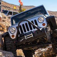
We are going to do an over night trip down into the Eldorado Range just south of Boulder City, NV.
We are going to explore around and hit some very scenic trails. Places we might/should hit up are... Keyhole Canyon (petroglyphs), Knob Hill, Powerline wash trail & down some washes to the river along Aztec Wash trail.
We plan to camp along the Colorado River as Fires are allowed along the river. (So bring Fire Wood!!!).
It will be cold overnight so be prepared!

 IV
IV
KadenVentures
Member# 23543

- Start Point: WB Conestoga before Nevada State, Henderson, NV 89002, USA GPS Coordinates: 35.99373, -114.93393 Notes: Shell Gas Station On WagonWheel Henderson, NV
This Rally Point location and route can be downloaded if the buttons are active. The “Launch Google Earth" option will allow you to review the location in 3D. Please keep in mind, actual terrain may vary greatly. This should be used for reference only.
Save KML Save GPX PDF Launch in Google Map Launch in Google Earth
Comments