Suggestions for secluded TRAILER camping locations NEAR MAX PATCH NC

  • HTML tutorial

Aaron Parker

Rank III
Member

Enthusiast III

875
Stem, NC
First Name
Aaron
Last Name
Parker
Member #

25398

Ham/GMRS Callsign
KK4WCJ
SOS!! Is there anyone out there?! COME IN NC OVERLANDERS!!

20200829_180158_HDR.jpg 20200829_204607_HDR.jpg

Sooo... I have looked and looked on all the tools I can find (Giagps, NFS, Google, etc) and I just can't seem to find the type of campsite I am hoping for. Looking for anyone with a good suggestion HELP! :D
After going out west... the east coast is simply smothering for an Overlanding spirit! Everything is either private property, illegal, or gated.. or all of the above.

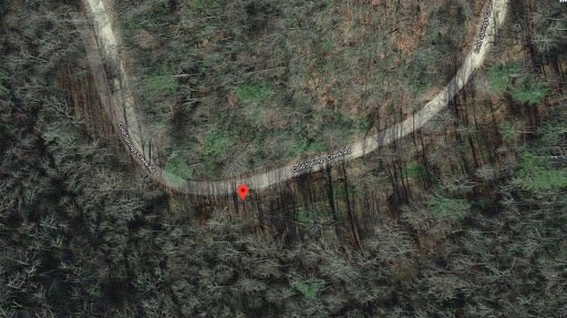
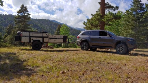
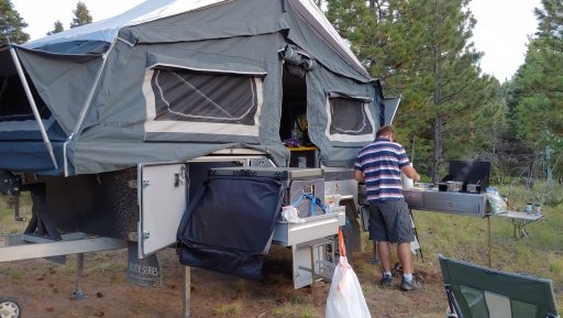
  1. Near Hurrican Creek/Max patch area (~10 miles in any direction or less than 30 min ideally)
  2. 2-3 days most likely
  3. As pretty and remote as is possible
  4. NOT near others... I.E. not a pay-to-play campground with someone 30 ft away making noise. If it was one of the few campgrounds that you honestly can't really see the other campers... I'd consider that.
  5. Ideally something similar to the attached pictures.
  6. Ideally able to have a small campfire
I just want to find a campsite to set up, then explore the area, drive some gravel and dirt, and come back at the end of the day to relax and get some food and sleep at the trailer. Any locals, or avid NC overlanders on the team... I'd LOVE to talk to you, feel free to reach out!!

Sincerely,
Desperate in the Carolinas
 

justjames

Rank V
Launch Member

Member III

2,306
Chapel Hill, North Carolina
Member #

9429

I'm not sure what you're looking for exists in that area. Partially from lack of flat ground and also it's proximity to the Appalachian Trail. If such a site exists, those who know about it probably won't share it on a public forum...........
My best suggestion is Round Mountain CG which is due north of Max Patch. You can find it on Google Maps.
 

Aaron Parker

Rank III
Member

Enthusiast III

875
Stem, NC
First Name
Aaron
Last Name
Parker
Member #

25398

Ham/GMRS Callsign
KK4WCJ
I'm not sure what you're looking for exists in that area. Partially from lack of flat ground and also it's proximity to the Appalachian Trail. If such a site exists, those who know about it probably won't share it on a public forum...........
My best suggestion is Round Mountain CG which is due north of Max Patch. You can find it on Google Maps.

Yeah... I told the wife tonight that we need to uproot and move west. It is just so 'cramped' on the east coast. Lived here my whole life... but it's just sad how little of it can be used. Like I mentioned in the post... it's all off-limits, illegal, or some other issue. Exploration or off-road travel is just nearly impossible to find in most areas on this coast. Too bad... sure is a ton of fun. :D

I'll look again at that CG... pretty sure I looked at that one too. THANKS!
 

justjames

Rank V
Launch Member

Member III

2,306
Chapel Hill, North Carolina
Member #

9429

Yeah... I told the wife tonight that we need to uproot and move west. It is just so 'cramped' on the east coast. Lived here my whole life... but it's just sad how little of it can be used. Like I mentioned in the post... it's all off-limits, illegal, or some other issue. Exploration or off-road travel is just nearly impossible to find in most areas on this coast. Too bad... sure is a ton of fun. :D

I'll look again at that CG... pretty sure I looked at that one too. THANKS!
Next best area that I'm aware of is not near Max Patch but is fun will be the area south of Blowing Rock. Look for a network of county gravel roads which leave Blowing Rock going due south on Globe Road. This area works west to the western side of Linville Gorge and Old Hwy 105 which is also gravel with some campsites on the lip of the gorge. These are first come first serve and primitive sites right along the road but they are still the best I can recommend. Hopefully more will chime in.
 
  • Like
Reactions: Aaron Parker

Sasquatch SC

Rank VI
Launch Member

Member III

3,782
Jefferson County, Colorado, United States
First Name
Trey
Last Name
Hayes
Member #

17253

Exit 7 off of I-40 is Harmon's Den. Head east and within the first 7 miles are dispersed sites scattered all along there. It is below Max Patch and those sites are used for equestrians as well so they are plenty big enough for a vehicle and trailer. Happy trails.
 
  • Like
Reactions: Aaron Parker

Aaron Parker

Rank III
Member

Enthusiast III

875
Stem, NC
First Name
Aaron
Last Name
Parker
Member #

25398

Ham/GMRS Callsign
KK4WCJ
Exit 7 off of I-40 is Harmon's Den. Head east and within the first 7 miles are dispersed sites scattered all along there. It is below Max Patch and those sites are used for equestrians as well so they are plenty big enough for a vehicle and trailer. Happy trails.
I had looked at that exit and even the Harmon den campground. Is there sites along cold springs creek road? Or are you saying near tje horse camp there are sites, not exactly part of the horse specific area?

I couldn't find an answer via google satellite images or other maps... Though I had looked pretty extensively.
 

Sasquatch SC

Rank VI
Launch Member

Member III

3,782
Jefferson County, Colorado, United States
First Name
Trey
Last Name
Hayes
Member #

17253

I had looked at that exit and even the Harmon den campground. Is there sites along cold springs creek road? Or are you saying near tje horse camp there are sites, not exactly part of the horse specific area?

I couldn't find an answer via google satellite images or other maps... Though I had looked pretty extensively.
Yeah that is Cold Springs. The sites are lower than the Harmon Den campground. There is one I've stayed at a few times pretty low down that has a nice little creek next to it, it is flat, and it's large enough we had 3 vehicles in there easy. It is at 35.75277, -82.99857. I have two others that I marked on that same trip but I never stayed there and don't recall how large they were: 35.76181, -82.99115 & 35.76410, -82.99500.

I remember seeing other sites but I didn't mark everything. I usually only save the sites that I may want to visit again. There are probably more that I didn't get to check out because of like a foot of snow along Brown Gap, Middle Road & Chestnut Ridge which are all off Cold Springs.
 

Aaron Parker

Rank III
Member

Enthusiast III

875
Stem, NC
First Name
Aaron
Last Name
Parker
Member #

25398

Ham/GMRS Callsign
KK4WCJ
I had looked at that exit and even the Harmon den campground. Is there sites along cold springs creek road? Or are you saying near tje horse camp there are sites, not exactly part of the horse specific area?

I couldn't find an answer via google satellite images or other maps... Though I had looked pretty extensively.
Yeah that is Cold Springs. The sites are lower than the Harmon Den campground. There is one I've stayed at a few times pretty low down that has a nice little creek next to it, it is flat, and it's large enough we had 3 vehicles in there easy. It is at 35.75277, -82.99857. I have two others that I marked on that same trip but I never stayed there and don't recall how large they were: 35.76181, -82.99115 & 35.76410, -82.99500.

I remember seeing other sites but I didn't mark everything. I usually only save the sites that I may want to visit again. There are probably more that I didn't get to check out because of like a foot of snow along Brown Gap, Middle Road & Chestnut Ridge which are all off Cold Springs.
Amazing info, thanks for the help and details!
 

Aaron Parker

Rank III
Member

Enthusiast III

875
Stem, NC
First Name
Aaron
Last Name
Parker
Member #

25398

Ham/GMRS Callsign
KK4WCJ
That's what Overland Bound is all about. Keep the shiny side up and the greasy side down!
Once again showing just how impossible it is to find this kind of detail without eyes on the soil... This is what Google maps show for that exact location (see pic) nothing about that would lead me to expect even a large shoulder to pull off on, let alone a full campsite space. I spent a LOOONG time on the maps 'walking' each road over and over hunting for what looked like pull-offs or cutouts that the forest service may have put in for this purpose... but it all just looks like woods and thin gravel as seen here.

Thanks again!

35_75277__-82_99857.JPG