Route and Trip Planning

  • HTML tutorial

jdunk

Rank VI
Founder 500
Member
Investor

Pathfinder II

4,387
King County, Washington, United States
First Name
Josh
Last Name
Duncan
Member #

0446

My wife and I are going on a 1,000+ trip in a couple weeks, and I was looking to put our planned routes into the Overland Bound One app and have everything about the trip loaded up into the (my wifes) iPad Pro for easy reference and tracking.

Historically, I've gone in to google maps, or my Garmin software created the routes and then just transfer them to my Garmin, Gaia, or whatever fancy tool I happen to be trying at the time. This has all ben done using the expansive monitor/desktop space of my desktop computer.

Now to get to my point, and please point me in the right direction.

It does seem that I can go into Google Maps, create my routes and export them as a KML/KMZ file. Then I will have to convert that to a GPX file, send that to my phone, and upload it to the app? (I'm assuming that once it's in the app, I will be able to sync the installed app on the iPad so everything is there).

Is that the only current method for route/trip planning? If so, is there any plan to bring some of the planning side of things to the website so that we can have more powerful resources to assist with the planning before pushing the data to the more portable and "on the road" type devices?

I get that most everything in this world needs to be "mobile first", but that doesn't make it any easier for my Commodore 64, Apple IIe brain to process.
 
  • Like
Reactions: OTH Overland

Ubiety

Rank VI
Member

Explorer I

5,221
Sammamish, WA, USA
First Name
Greg
Last Name
Ubiety
Member #

6193

Ham/GMRS Callsign
Ribs
I believe that planning via the web and syncing that to OB1 is on the list of TODOs. Reference this thread.
Yes, agreed. Very important feature ;)
 

M Rose

Local Expert
Mod Team
Member

Advocate III

5,584
Northeast Oregon, United States
First Name
Michael
Last Name
Rose
Member #

20990

Ham/GMRS Callsign
W7FSB
Service Branch
US ARMY Retired
KML/KMZ support is in the works as we speak. There is a rumor that the website is getting a major update soon, and then OB1 is getting overhauled to OB 2.0.

Before your trip, play around with the app in town… there’s are features which are kind of hidden at the moment… I will be post a few later tonight that I just learned how to do which will be really important when using the app to fallow your progress.
 

jdunk

Rank VI
Founder 500
Member
Investor

Pathfinder II

4,387
King County, Washington, United States
First Name
Josh
Last Name
Duncan
Member #

0446

KML/KMZ support is in the works as we speak. There is a rumor that the website is getting a major update soon, and then OB1 is getting overhauled to OB 2.0.

Before your trip, play around with the app in town… there’s are features which are kind of hidden at the moment… I will be post a few later tonight that I just learned how to do which will be really important when using the app to fallow your progress.
I’ve been playing with the app on the wife’s iPad for a little while now. It’s really nice for a lot of things. I especially like how smooth and responsive it is.

I will say that so far, if I want to read the forums, I find myself going back to the website.

That said, I see great potential and am very happy I invested in the project!

We’re definitely going to be playing with it on our next trip, even if it is not our primary navigation and research platform.
 

Michael

Rank IX
Staff member
Founder 500
Member

Benefactor

15,584
Livermore, California, United States
First Name
Michael
Last Name
Murguia
Member #

0000

Ham/GMRS Callsign
KM6YSL
Posting a preview of OB1 route planning here. This shows:

- Street planning
- Switching to secondary road planning (the walking dude) to tell route planning to consider unimproved roads while routing
- Switching to “as the crow flies” so you can route if/when there are no roads and then going back to unimproved road mode.
- Using map search while route planning and not losing your route :)
- Editing a point by dragging.

This is just about Alpha, and we’re planning to get MVP live in the next few weeks.


Ubiety

Rank VI
Member

Explorer I

5,221
Sammamish, WA, USA
First Name
Greg
Last Name
Ubiety
Member #

6193

Ham/GMRS Callsign
Ribs
Posting a preview of OB1 route planning here. This shows:

- Street planning
- Switching to secondary road planning (the walking dude) to tell route planning to consider unimproved roads while routing
- Switching to “as the crow flies” so you can route if/when there are no roads and then going back to unimproved road mode.
- Using map search while route planning and not losing your route :)
- Editing a point by dragging.

This is just about Alpha, and we’re planning to get MVP live in the next few weeks.

Very cool! Is internet access required to use the route planning feature? Have you considered a different icon for the "walking dude" - he kind of implies routing for a hike. Maybe some kind of offroady symbol for unimproved roads, like a gnarly mud tire or "4x4"? Will the "unimproved roads" follow "improved roads" as well? Assume that "as the crow flies" will never follow any kind of roads.

Awesome work!!!
 

Michael

Rank IX
Staff member
Founder 500
Member

Benefactor

15,584
Livermore, California, United States
First Name
Michael
Last Name
Murguia
Member #

0000

Ham/GMRS Callsign
KM6YSL
Very cool! Is internet access required to use the route planning feature? Have you considered a different icon for the "walking dude" - he kind of implies routing for a hike. Maybe some kind of offroady symbol for unimproved roads, like a gnarly mud tire or "4x4"? Will the "unimproved roads" follow "improved roads" as well? Assume that "as the crow flies" will never follow any kind of roads.

Awesome work!!!
Wow - internet access - fantastic question.

I would love your feedback on the walking dude - here is the way that is actually done:

Directions are optimized, and derived using a routing network, made up of "ways" that have attributes associate with them, like travel speed limit, has bike lane, secondary route. At some point, low speed limit routes break-over to be considered a trail. In the case of offroad navigation, because of the low speeds associated with certain "roads", they are not considered for high-speed route planning. We have to be careful, because we can't have our app suggesting that a walking path is suitable for off-road vehicles.

Perhaps the icon methodology should be highway, trail, bicycle, crow - with trail being generic enough to not indicate it is a road.

Walking dude definitely does go on main streets, but prefers secondary routes - so you wouldn't want to use it to go from San Francisco to Los Angeles. It would take FOREVER - it explicitly prefers to use everything but main roads.

As the crow flies will always be wherever you tap - not routing.

Happy to get feedback!
 
  • Like
Reactions: Ubiety and M Rose

kunstmilch

Rank V
Member

Advocate II

1,597
Pomona, CA, USA
First Name
Erich
Last Name
Wise
Member #

29953

Ham/GMRS Callsign
GMRS call sign: WRFL229
The main feature that no app seems to have (in any way I have found) is to be able to pick my location or start location, pick a destination (say a campsite or whatever) and have an editable route planned out with filters like "only unpaved paths" that would find the least paved path to my destination, then I can drag around the route to choose a different path if I didnt like what it generated. Also the ability to add routes or trails to the path. Possibly have it adjust on the fly like Apple Maps does if I go off course. This would make it the most useful app.
 

M Rose

Local Expert
Mod Team
Member

Advocate III

5,584
Northeast Oregon, United States
First Name
Michael
Last Name
Rose
Member #

20990

Ham/GMRS Callsign
W7FSB
Service Branch
US ARMY Retired
The main feature that no app seems to have (in any way I have found) is to be able to pick my location or start location, pick a destination (say a campsite or whatever) and have an editable route planned out with filters like "only unpaved paths" that would find the least paved path to my destination, then I can drag around the route to choose a different path if I didnt like what it generated. Also the ability to add routes or trails to the path. Possibly have it adjust on the fly like Apple Maps does if I go off course. This would make it the most useful app.
This is coming soon… in Expedition Tier and first to web, then it will be ported to the app.
 
  • Like
Reactions: Ubiety

Michael

Rank IX
Staff member
Founder 500
Member

Benefactor

15,584
Livermore, California, United States
First Name
Michael
Last Name
Murguia
Member #

0000

Ham/GMRS Callsign
KM6YSL
Hey guys - we are working on this right now. Here are some of the things you can do with our Route planning scheduled for the next release (~2 weeks).

- Choose how-to route (paved, secondary, walking, as the crow flies) for each waypoint.
- Edit these waypoints at any time by clicking them.
- Export the current version as a GPX for someone else to use (or to add to the app as a Offroad Trail POI
- Share your route privately to whoever you want.

You will be able to come back to your route at any time (after actually traveling it lets say) to modify it. All of this will be available with v1.0 of route planning, though we will want UI improvements in the future to make it more intuitive, but we really feel this is a good, polished MVP or Route Planning.

Looking forward to getting this in your hands!
 
  • Like
  • Love
Reactions: Ubiety and M Rose

zgfiredude

Rank VI
Member

Steward I

3,953
Silt, CO, USA
First Name
Brian
Last Name
Nichols
Member #

28938

Service Branch
Firefighter
Couldn't come at a better time as I am evaluating Gaia (my current format) vs. OnX. I haven't attempted any use of OB1 as it has been missing this functionality.
 
  • Love
Reactions: Michael

kunstmilch

Rank V
Member

Advocate II

1,597
Pomona, CA, USA
First Name
Erich
Last Name
Wise
Member #

29953

Ham/GMRS Callsign
GMRS call sign: WRFL229
So I made a route to a campsite from my house in Gaia as I still have no understanding if thats even possible in OB1 yet, but I cant find a way to download or upload or whatever the file into OB1, seeing as Gaia crashes on my iPad I thought this would be a good opportunity to trial OB1 on a small weekend trip. Is this even possible cause I cant figure it out. For some reason everything about OB1 is unintuitive.
 
  • Like
Reactions: Michael

Michael

Rank IX
Staff member
Founder 500
Member

Benefactor

15,584
Livermore, California, United States
First Name
Michael
Last Name
Murguia
Member #

0000

Ham/GMRS Callsign
KM6YSL
So I made a route to a campsite from my house in Gaia as I still have no understanding if thats even possible in OB1 yet, but I cant find a way to download or upload or whatever the file into OB1, seeing as Gaia crashes on my iPad I thought this would be a good opportunity to trial OB1 on a small weekend trip. Is this even possible cause I cant figure it out. For some reason everything about OB1 is unintuitive.
Simple answer is yes you can!

That means we have work to do on the UI. We spent so much time on UX - but it's all about making it easy so we will iterate until we get it right! Lets see if we can give you a couple pointers.

1. To import a GPX into OB1 - just tap on it in your OS, and select OB1 as the application to open the file in. This part is not an OB1 thing - this is a phone OS thing. When you do, it will open in OB1 and you will see "Quick Save" and "Add Details" as options - I'd just select Quick save because it is instant. If you want to, you can add a bunch of details and pictures.

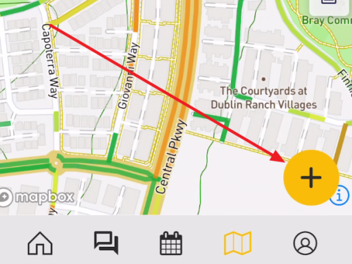
2. to Record a track in OB1, there is a bid yellow "+" on the map...

1659575865551.png

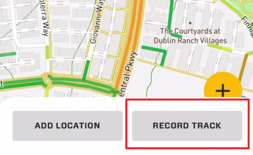
Click it.

1659575928282.png

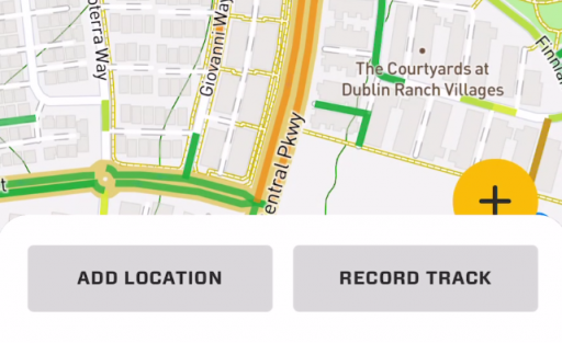
In your case, you would select "Record Track".

I'd love feedback on how we can make this easier! If its hard, it doesn't help our community!

Here are a couple tutorial videos to get you started - but I am also very happy to answer questions.


Attachments

kunstmilch

Rank V
Member

Advocate II

1,597
Pomona, CA, USA
First Name
Erich
Last Name
Wise
Member #

29953

Ham/GMRS Callsign
GMRS call sign: WRFL229
Thank you, once explained it worked as you suggested. I think I was expecting the "plus" sign to allow getting the tracks like how computers tend to work but I now get it.
 
  • Like
Reactions: Ubiety and M Rose

kunstmilch

Rank V
Member

Advocate II

1,597
Pomona, CA, USA
First Name
Erich
Last Name
Wise
Member #

29953

Ham/GMRS Callsign
GMRS call sign: WRFL229
LOL FML I shouldn't have made the track from my house, as I use it I'll obviously get better at this. Hahah Apple Maps wants to guide me to my driveway for OB1 to take over. Funny how that works but informative.
 

Michael

Rank IX
Staff member
Founder 500
Member

Benefactor

15,584
Livermore, California, United States
First Name
Michael
Last Name
Murguia
Member #

0000

Ham/GMRS Callsign
KM6YSL
Thank you, once explained it worked as you suggested. I think I was expecting the "plus" sign to allow getting the tracks like how computers tend to work but I now get it.
Excellent! That "+" button may be an area for improvement. It is context sensitive, so it does a different thing if you are on the Rally point tab, or the Member tab of the map. I can see how that could be confusing!

Please let us know if you have any further questions - writing documentation as fast as I can! :)

M
 

OTH Overland

Local Expert Washington, USA
Member
Investor

Trail Blazer III

4,847
Camano Island, WA, USA
First Name
Dave
Last Name
Ballard
Member #

20527

Ham/GMRS Callsign
N7XQP
Service Branch
Fire/EMS/SAR
I get that most everything in this world needs to be "mobile first", but that doesn't make it any easier for my Commodore 64, Apple IIe brain to process.
Alas, I am still working with a TRS-80 Computer brain...lol That was our first computer back in about 1979, came complete with a whopping 4k of Ram, and the optional external storage drive (a fancy cassete tape player) took forever to do anything on it. Never guessed back then we would be using such a device to pre-plot a trip across country via forest service roads, and then upload it to a magic display that speaks to you in a digitized voice telling you where to go as you drive!