Harrison to Pemberton FSR 11Aug2018 - (2019 update)

  • HTML tutorial

CR-Venturer

Rank VI
Launch Member

Traveler III

3,372
Ardrossan, AB, Canada
First Name
Jas
Last Name
Spr
Member #

16340

Hey BC Overlanders!

I'm really itching to do the Harrison - Pemberton FSR route on August 11th, but all my usual wheeling buddies have bailed on me or are tied up.

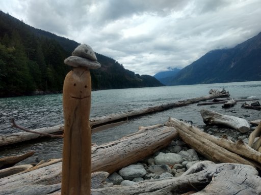
I know that there's a washout at 56km at the bridge over Bremner creek, but my research indicates that BC4WD association has found/created and used a water crossing to bypass the closure. I want to head up there and check it out, possibly attempt the water crossing. The creek was very high in the spring, but it's August now so the water should be way, way lower. Even if it's not possible to make it, I figure it's a fun day out driving the backroads and exploring the beauty of one of BC's most historic routes. If we do make it, we can be back country heroes!

I'm thinking of a fairly early start, perhaps 0800h meet at the turn off from Lougheed at the Sasquatch Inn.

Any takers? reply here or shoot me a PM and we'll make arrangements.
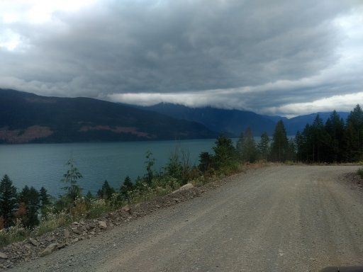
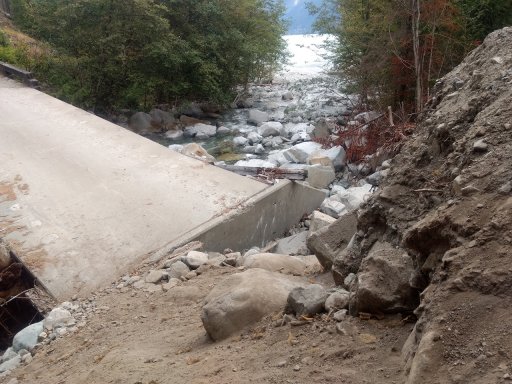
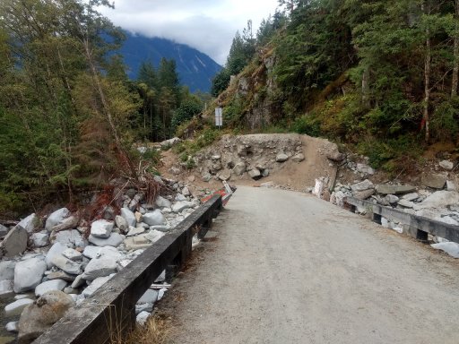
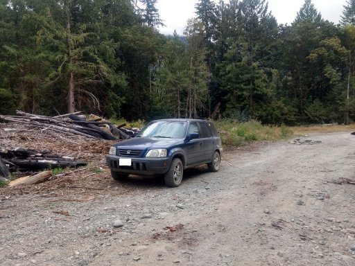
 
Last edited:

CR-Venturer

Rank VI
Launch Member

Traveler III

3,372
Ardrossan, AB, Canada
First Name
Jas
Last Name
Spr
Member #

16340

So I rolled today with my eldest daughter to scout the Harrison to Pemberton FSR route, specifically to scope out the water crossing around the washout at Bremner creek at 55kms (or 56 depending on what sign you believe). We ended up leaving home a bit late, around 10am, and we had a pretty leisurely drive out there. The FSR itself is very level and pretty well graded. Most of it could be driven by a 2wd. Some gorgeous views on the way.
IMG_20180811_143647835.jpg
The washout is pretty bad, but dual sport or dirt bikes can definitely make it through if they walk the bikes part of the way. In fact we met a pair of adventure bikers who had just come through from Pemberton.
IMG_20180811_123508337.jpg
IMG_20180811_134713711_HDR.jpg
Fortunately, down a side track before the washout, seen here disappearing into the woods behind/right of the V, there is a water crossing route.
IMG_20180811_123420122_HDR.jpg
The water crossing - I've highlighted in red the shallowest path through the water. I think with either a spotter willing to get wet, or a pre-plotted course marked with sticks jammed into the lake bed, I could drive this route in the V as it is now. I wouldn't necessarily want to try without a buddy with another vehicle present though.
crossing1.jpg
More to follow next post.
 

CR-Venturer

Rank VI
Launch Member

Traveler III

3,372
Ardrossan, AB, Canada
First Name
Jas
Last Name
Spr
Member #

16340

This shows the path along the bar and onto the beach. The circle indicates the exit point which I'll show more detail of later on:
crossing2.jpg
Once onto this little bar, I think it would be pretty easy. The water is very shallow here and the approach onto the beach is fairly gradual. There is a clear path across the beach toward the circle, and only a very shallow, short water crossing that's just out of sight in this pic.

The lower line, indicated with the arrow, is the highest water depth on the shallow pathway across the water crossing (I walked it a few times). The upper line is the deepest water point outside of this shallow path. The first water line is just below or just at the door seals of my V, and I think from what I've seen other guys do, it would be possible as it is without wrecking the vehicle.
IMG_20180811_134121453.jpg
However, as the previous pics show, the "shallow path" is a bit tricky to follow, as it curves out from the shore and does an almost 90 degree turn toward a little bar. It would be tough to stay on this shallow underwater "road" without either a good spotter standing in the water, or having pre-marked one edge of it with sticks stuck into the lake bed. Also, there are some very big boulders under there that you'd have to avoid in a vehicle like mine.

A vehicle with more lift than I have such as a jeep wrangler with big tires could just do this crossing without worrying about the shallowest path. Having said that, I've seen a video of a CRV doing a water crossing with water up to the plastic trim on the doors, but I frankly don't want to risk that depth without more mods lol.

The exit back to the FSR on the far side:
IMG_20180811_140511955_BURST000_COVER_TOP.jpg
We left a sentry to watch the route for us:
IMG_20180811_140300648_HDR.jpg Sadly, for today, we couldn't make the attempt even if I decided to risk it, as campers barred the way. The tent is basically sitting right where my vehicle would have to pass, and I didn't really want to ask them to move it and a bunch of their other stuff. On a different day, I could probably fashion a nice little ramp of the driftwood lying around and pass this easily:
IMG_20180811_133227980.jpg

All in all, we had a sucessful scouting mission and a grand adventure. We saw a coyote running along the middle of the road, which was cool, and we even saw some backwoods oddities. Beehives in the middle of nowhere (on crown land):
IMG_20180811_154516254.jpg
And this unfortunate vehicle - it was an old wreck, and I checked it out. I suspect the folks were relatively unharmed, judging by the state of the cabin. Bet it scared the crap out of them though.
IMG_20180811_145618797_HDR.jpg
We also picked up a bunch of trash and helped out a young guy who had a flat tire and was driving up in a Ford Transit Connect. Some Jeepers and a fellow in a sweet 4Runner also stopped to help, and between us all we had the guy fixed up in no time. We had him air down his tires a bit too, as he was running cheapo low profile street tires and full road pressure! Hopefully he got through his last 5 clicks unscathed and made it where he needed to go.

Sometime, I hope to return with my wheeling buddies and actually attempt the water crossing. There is another washout further up beyond this first one, but judging by the footage, the water is far shallower, and I suspect it would be no problem for the V. That remains to be seen though.
 
Last edited:
  • Like
Reactions: Railvan

Railvan

Rank III
Launch Member

Enthusiast II

814
Washington
Member #

14427

Does anyone know if there are plans to replace this bridge? I'm guessing yes, but they are waiting on the funding?
It looks like if the steep bluff at the end of the bridge was either dug out to create a lesser slope, or fill added on the bridge that this could be passed by most 4x4's. I doubt the province would like people doing this to the road and bridge. Too many liabilities. Too bad as I'd love to take this road and explore the area.
 

CR-Venturer

Rank VI
Launch Member

Traveler III

3,372
Ardrossan, AB, Canada
First Name
Jas
Last Name
Spr
Member #

16340

Hi Railvan,

I've heard that there are timber leases or somesuch thing invovled, and nobody is in a hurry to fix it. The bridge is impassable by 4x4 mostly due to two gigantic boulders they've stuck in the way, although motorbikes can pass.

Fortunately the water crossing is quite viable for most 4x4's. With proper prep, I'm pretty confident my CRV can make it. Someone with more clearance could do it pretty easily.
 

syncro_de_maya

Rank II
Launch Member

Enthusiast I

434
Vancouver BC Canada
First Name
Maya
Last Name
Roza
Member #

10387

Ham/GMRS Callsign
VA7LZR
Was this on the west or east side of Harrison? We made to the Clear Creek hotsprings back in early June, would be a shame if that was cutoff with a bridge out like that.
 

CR-Venturer

Rank VI
Launch Member

Traveler III

3,372
Ardrossan, AB, Canada
First Name
Jas
Last Name
Spr
Member #

16340

Was this on the west or east side of Harrison? We made to the Clear Creek hotsprings back in early June, would be a shame if that was cutoff with a bridge out like that.
This is on the FSR formerly known as Harrison West, about 56km up. There is also another washout further up from this one, which of course I wasn't able to reach on this trip.
 
  • Like
Reactions: John Hogewoning

CR-Venturer

Rank VI
Launch Member

Traveler III

3,372
Ardrossan, AB, Canada
First Name
Jas
Last Name
Spr
Member #

16340

The bridge is currently being replaced should be done in the spring after the snow melts, hope everything opens up by late spring
Outstanding news! Thanks for the update :D Maybe next summer, my bud's and I will do a trip up west Harrison and then do the Hurley to Carpenter lake. Would be an epic journey.
 
  • Like
Reactions: John Hogewoning

Tfeldtaco

Rank I
Launch Member

Traveler I

233
Edmonton, AB
First Name
Tn
Last Name
Feld.
Member #

13279

Depending when you guys do it I’d be willing to join if your open to another vehicle to the convoy!
 

Shaun Huth

Rank II
Launch Member

Enthusiast I

404
Edmonton, Alberta
First Name
Shaun
Last Name
Huth
Member #

11104

Hey there, any update on this? I'm wondering if this would be passible now with my Trailhawk and trailer. Great story so for by the way!!
 

CR-Venturer

Rank VI
Launch Member

Traveler III

3,372
Ardrossan, AB, Canada
First Name
Jas
Last Name
Spr
Member #

16340

Hey there, any update on this? I'm wondering if this would be passible now with my Trailhawk and trailer. Great story so for by the way!!
Hey there!

Yes, actually the old bridge has been cleared, new support beams have been laid, and apparently some road improvement work is being done on either side of the bridge. It seems like the bridge is coming soon. As for the water crossings, presently there's been a ton of rain, so I think the water level is about 2.5 to 3 feet deep and around 20 feet across. I got the intel from a FB group I follow regarding this road. I keep a close eye on it, because I'd absolutely love to run this trail from start to finish.

If I hear of the bridge getting finished, I'll post an update here.

Cheers!
 

Tfeldtaco

Rank I
Launch Member

Traveler I

233
Edmonton, AB
First Name
Tn
Last Name
Feld.
Member #

13279

Hey there!

Yes, actually the old bridge has been cleared, new support beams have been laid, and apparently some road improvement work is being done on either side of the bridge. It seems like the bridge is coming soon. As for the water crossings, presently there's been a ton of rain, so I think the water level is about 2.5 to 3 feet deep and around 20 feet across. I got the intel from a FB group I follow regarding this road. I keep a close eye on it, because I'd absolutely love to run this trail from start to finish.

If I hear of the bridge getting finished, I'll post an update here.

Cheers!
What FB group are you getting your info from? I'm planning to come down from Edmonton - Vancouver on primarily dirt roads so I was hoping to try the Harrison FSR going N-S.

My tentative route is on this link: Summer Trip
 

Tfeldtaco

Rank I
Launch Member

Traveler I

233
Edmonton, AB
First Name
Tn
Last Name
Feld.
Member #

13279

The group is In-Shuck-Ch Road Updates. When are you planning to be here?

I'm going to say sometime around next weekend. I plan to Leave Nordegg on Monday and slowly make my way there. I don't want to rush the trip so aiming for 5-7 days of driving before arriving in the lower mainland. Any chance you've been up to Clear Creek Hotsprings? Google reviews says its accessible by 4x4 so thinking about popping in there to check it out.
 

CR-Venturer

Rank VI
Launch Member

Traveler III

3,372
Ardrossan, AB, Canada
First Name
Jas
Last Name
Spr
Member #

16340

I'm going to say sometime around next weekend. I plan to Leave Nordegg on Monday and slowly make my way there. I don't want to rush the trip so aiming for 5-7 days of driving before arriving in the lower mainland. Any chance you've been up to Clear Creek Hotsprings? Google reviews says its accessible by 4x4 so thinking about popping in there to check it out.
I've never been to clear creek, no. What rig are you driving? I was thinking if you end up on West Harrison next Saturday, I might be able to pop up to meet you at Bremner Creek to try to help with the water crossing. I know two possible routes for it, and I could even potentially help tow/snatch you out if you got stuck.