Continental Divide and Colorado BDR

  • HTML tutorial

velo47

Rank VII
Launch Member

Member III

6,184
Albuquerque, NM, USA
First Name
Matt
Last Name
Harland
Member #

21731

Ham/GMRS Callsign
W3TAX
You're right that is mostly dirt.

I took Hwy 352 North just west of Pinedale proper. This turns into Green River Lakes Road. A little ways up you turn left onto Union Pass Road. About 45 miles from Pinedale, bear right to get on Forest Road 263. Continue about 20 miles and you'll T into Union Pass Road again. Go right onto Union Pass Road and follow it to US 26 - 287. Turn right and it's a quick hop into Dubois.

I am looking at GAIA on my computer so distances are approximate. Union Pass Road does not look like it goes through, hence the stint on Forest Road 263. Google maps, though, shows it as Union Pass Road all the way through.
 
  • Like
Reactions: Sparksalot

velo47

Rank VII
Launch Member

Member III

6,184
Albuquerque, NM, USA
First Name
Matt
Last Name
Harland
Member #

21731

Ham/GMRS Callsign
W3TAX
Day 24 – Granite Butte, MT to Columbia Falls, MT – 235 miles


This morning I woke up and started making coffee, the usual morning routine. The weather was really nice, so I had the sliding door open on the van.

I thought I hears something in the brush but wasn’t sure.

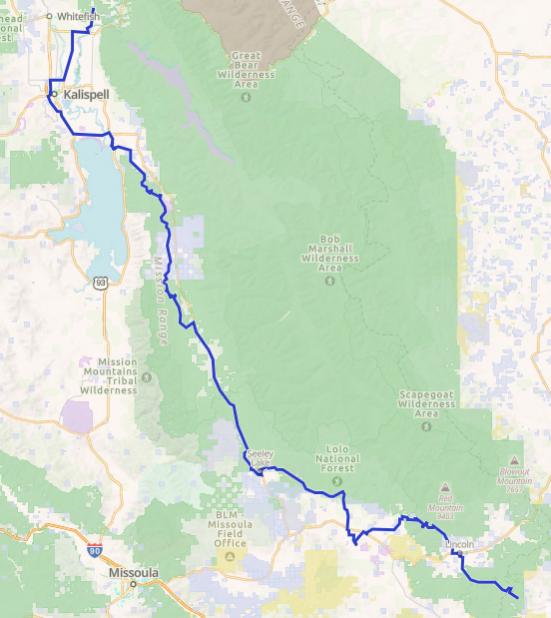
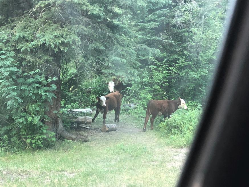
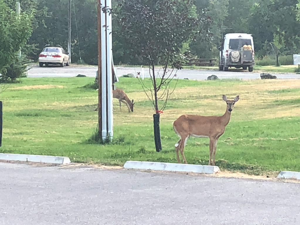
Spidey senses were up, and sure enough, there was something moving through the brush down by the creek. I kept looking and saw a flash of brown, light brown…

Then, soon enough, here comes mama with 2 young’uns up from the creek right into my camp. They circled around the van and finally wandered off down the stream to harass some other campers.


Stupid cows.

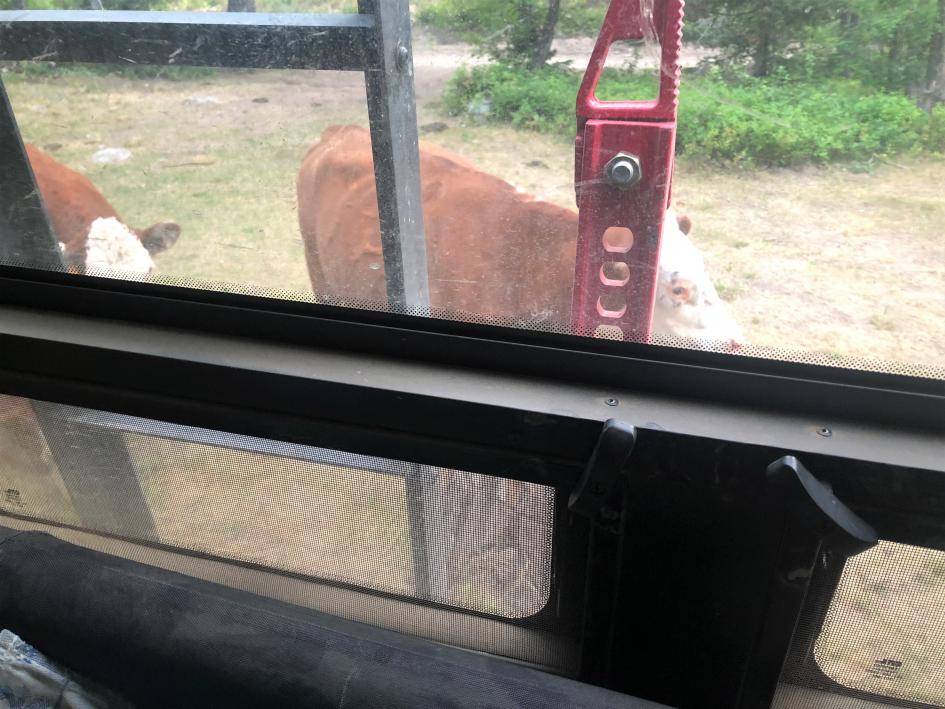
I started out northward, glad to be away from my tormenters. Up to Lincoln, over Huckleberry Pass, and on towards Ovando. A large portion of this area has been hit by wildfires, and is just starting to recover.


On the way, I decided to stop at the Harry Morgan access sight and do a little fishing on the Blackfoot River. This site is named not for Colonel Potter, but for an early pioneer and one of the first game wardens in the Blackfoot Valley.

I got to Hwy 200 and made not one but two wrong turns before I got to the fishing access. It was hot and fishing was slow (or maybe it’s just me?) and storm clouds were looming, so after an hour or so, I packed it up and went into Ovando.

When I was in Missoula a couple days ago, my stepdaughter told me about a fatal grizzly attack that had just happened near Ovando. That and all the grizzly warning signs along the route were definitely a factor in my early morning jumpiness!

It was still early and I thought I’d continue on and find camp around Seeley or Swan Lake. This area, although very touristy, is beautiful, with Highway 83 skirting the east side of both lakes before it finally dumps out right by the giant Flathead Lake. The route goes around the west side of Seeley Lake, and was so heavily wooded that you really don’t get the great lake views you would on the highway. Still, it was a nice drive.

Back onto Hwy 83 to go to Swan Lake, where I really wanted to camp. The route again takes off to the west side of the lake, and up into the mountains, with only glimpses of the lake. The terrain was steep and wooded. Beautiful drive, but very few campsites along the way. The route finally Ts into Highway 209 right by Bigfork on Flathead Lake.

By this evening hour, of course all the campgrounds were full to the gills, and with little public land in the area, I headed to Kalispell, where you can camp at the fairgrounds. Not ideal, but better than nothing. Well, camping was closed because of a livestock show.

On to Columbia Falls, where all the campgrounds and even RV parks were full.

Finally, around dark I found a spot in the National Forest not far off Highway 486. I went farther up into the Forest looking for a more secluded site, but a couple very sketchy looking, permanent looking, drug addict looking camps had me back near the highway. The site was actually very nice and quiet and worked out just fine.
 
  • Like
Reactions: Offroadnutz

velo47

Rank VII
Launch Member

Member III

6,184
Albuquerque, NM, USA
First Name
Matt
Last Name
Harland
Member #

21731

Ham/GMRS Callsign
W3TAX
Day 25 – Columbia Falls, MT to Eureka, MT – 135 miles


Although my vacation will continue for another couple weeks, today is the last day of my CDR adventure.

The Canada border is only about 135 miles away. I head to Whitefish and then up along the east edge of Whitefish Lake, by lots of expensive beautiful houses. Very affordable too. ;o)

Then the road narrows and turns to dirt. There is active logging in the area, and I wish I had a CB radio, as that is what the loggers use up here. With yet another radio to supplement the HAM, GMRS, SpotX, tablet, and phone, the cockpit will look like, well, a cockpit! Outside, the van will start to look like a pin cushion with so many antennae!


Maybe 40 miles from my camp lies tiny Upper Whitefish Lake, a beautiful site with a nice campground. I really wish I knew about this before I spent a bunch of time looking for a spot farther south down by Flathead.


I’d heard about Polebridge Mercantile several times, so when I got to North Fork Road, I detoured south to see it. I don’t know what I was expecting, but it was kinda underwhelming. Very touristy. They did have a fruit stand next door with a big sign for fresh local cherries. The Flathead area grows awesome cherries, so I thought I’d get some as a gift for my friends in Yakima. No such luck, cherry delivery was delayed until that afternoon. They did have pineapples, though, which, when quizzed, the vendor jokingly said they grew on the back 40.

The route continues north and west through the national forest until it finally T’s into US 93 just south of Eureka. I continued up US 93 to the Canada border at Roosville. The border was still closed except for some commercial traffic, it seemed.


Wow, that’s the end of the road!

I headed back down into Eureka and had a good late lunch at Café Jax. I toured the historic pioneer town (very cool) and decided to stay right in Eureka at the city park (suggested donation $10) right on the Tobacco River. I threw in a line, but didn’t catch anything, not that I tried very hard.
Walked up Main Street to Fire and Slice Pizza for beer and pies and AC, but the AC was lacking. The pizza and beer were good.

Eureka seems to be inhabited by more turkeys and whitetails than locals. I’ve never seen so many hens and poults in one place!


It’s a very friendly town where you can still get free air at the gas station when your compressor finally craps out! At least it was on the last day!

VanCompass in Post Falls, ID just got a shipment of ARB Duals in! Mark and Rob are the best, and their employees are very helpful. If you ever need something for a van, they’re the place!

Final thoughts and observations coming soon.

Thanks for following along!
 
  • Like
Reactions: Offroadnutz

velo47

Rank VII
Launch Member

Member III

6,184
Albuquerque, NM, USA
First Name
Matt
Last Name
Harland
Member #

21731

Ham/GMRS Callsign
W3TAX
Final Thoughts, in no particular order

The CDR and COBDR portion of the vacation was 25 days and about 4,250 miles from home in Albuquerque. That includes the trip down from Albuquerque down to the border, the detour to Glenwood Springs for tires, and the detour to Missoula for Walleye.

From Eureka, I drove to Yakima, WA to visit friends. Then to Missoula and Philipsburg, MT for a couple weeks relaxing with relatives. Then home to Albuquerque with my wife, stepson, and grandson. Total mileage for the 43 days was about 6,600 miles.

I thought I could get one last trip out of the front tires. This was a mistake, and I should have gotten new ones before I left.

I’m putting the new ARB twin compressor under the hood. The current single ARB is under the van and gets caked with mud. All the time. That can’t be good. Hopefully I can rebuild the single and put it in my Colorado.
Does anyone have any tips? The motor runs, it just doesn’t pump much if any air.

I’m glad I have a winch. I never used it. A pull-pal would be nice for the wide open areas in NM and WY.

I love having the SpotX. So much of this trip was out of cell service. It is layer of comfort for both me and my wife, and she and the grandson can follow my progress on the computer.

What fun it is to travel and meet new people and to travel with “old” friends! But going alone adds to the adventure, too. When I’m by myself I need to slow down and do more detours to see the sights. Or maybe just stop early and relax if I find a really nice campsite.

The van performed great. It’s big, but no longer or wider than a new full-size truck, really. It is tall, and you sit up high, so it feels even bigger. It’s got a lot of new pinstripes.

There was no instance where I was even close to getting stuck. Partly because I bypassed Fleecer Ridge in MT and some mud in NM. We didn’t do the “hard” passes in CO, but they were hard enough. There were a couple spots where I thought I was going to have a problem (like Hagerman where the Tundra was temporarily stuck in front of us), but the van handled it no problem. I only scraped the skids a few times.

Do I want to do more of the high mountain passes in CO? Not really, at least not in a big vehicle. I spent most of those days looking at the road, trying to anticipate the ever-present traffic, and a little stressed about what laid ahead. I didn’t really get to look around and see the sights except when we stopped.

Would I want to do the high mountain passes as a passenger? No way! I like being in control. Plus, you have the steering wheel to hold onto.

Traffic! Wow, there were a lot of vehicles on the passes in Colorado. It was just after 4th of July weekend, but still…

I’m more cautious by myself. I don’t want to spend a day digging out of mud by myself. Or trying to winch up or back down Fleecer Ridge. Even if I could.

It was kinda a let-down to finally get to the Canada border.

6 weeks is a long time to be away from home.

Am I glad I did it? HECK YA!

What’s next? Beats me, maybe the Mojave Road in the spring. Then the Idaho or Utah BDR. Maybe the Enchanted Rockies Trail. Maybe the Trans-America Trail? The Great Western Trail?

If anyone has any questions, comments, suggestions, fire away!
 

cgranier

Rank VI
Member

Trail Blazer II

3,340
Miami, FL, USA
First Name
Carlos
Last Name
Granier
Member #

30043

Still there two weeks ago when we did the COBDR!


Sorry for the hiatus, I had to go to DC to see my mom.
After I posted day 14, I was re-watching a couple of the videos that Larrie @Luinil Explorations posted that showed their CO BDR trip last September. Watching the Hagerman pass video, I noticed this car and immediately recognized it.


That same car was in the same place when we went over Hagerman in August of this year, almost a year later!


The car was very near the top of the pass, and kind of precariously parked it seemed. It's funny that Bill remembered the car from our trip, and so did Larrie from his. It wasn't in a spot you'd expect, so it stuck in our minds. According to GAIA and OnX, there is no private land inholding or mining claim there.

The car sure didn't look as though it had been there all winter, and didn't look damaged or abandoned, but it seems to be in the exact same place.

So, what do you think? There all year? Just coincidentally in the same place? Mushroom hunter? Pot grow? Who knows?
 

P8trit

Rank II

Enthusiast III

443
Montana
First Name
Travis
Last Name
Campbell
Wow that was fun and alot of great info to help with planning our CDT adventure. Thank you..