Connecting the forests in Central Pennsylvania

  • HTML tutorial

DevilDodge

Rank IV

Advocate I

1,135
Altoona, Pennsylvania, USA
First Name
David
Last Name
Spencer
Just wanted to brainstorm with my plan. I have been scouting out the area making sure I get plenty of time in the forests while I wait for the opportunity to make it a trip.


I always hear that Pennsylvania just doesn't offer the experiences the west does. But I noticed a lot of people assume Pennsylvanians live in Philadelphia or Pittsburgh. And it is completely overlooked that we have forests...


And I know alot of people like to follow a known route, like the MABDR or Appalachian By way. But these drive you right past some of the best off pavement travel on the east coast. Everything on this route will be public roadways. So no special group to join to access all there is to offer.


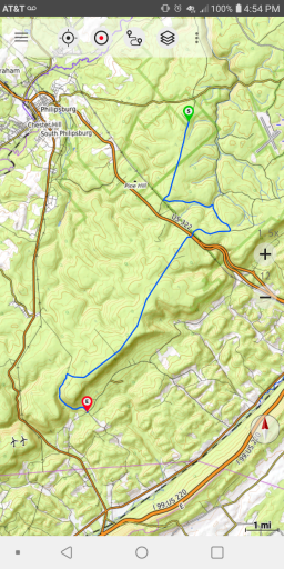
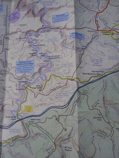
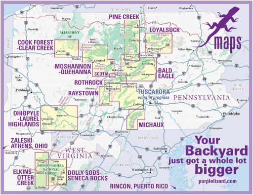
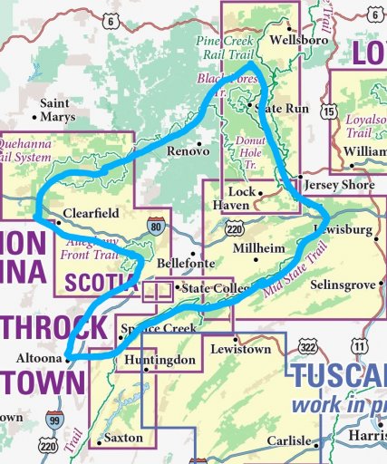
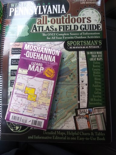
So. Onto my journey. I have been planning and scouting a trip around Central PA. I included a pic showing what is available in Central PA and then the overview route. I am just using paper maps and atlases and am so glad i found the Purple Lizard Maps . They have made exploring along this route so much more in depth.
2021_PLP_locator_August_v1_lettersize_copy_752c2435-d86c-48e1-8e32-f435e594f63e.jpg2021_PLP_locator_August_v1_lettersize_copy_752c2435-d86c-48e1-8e32-f435e594f63e~2.jpgScreenshot_20210817-134733~2.png2021_PLP_locator_August_v1_lettersize_copy_752c2435-d86c-48e1-8e32-f435e594f63e~3.jpg2021_PLP_locator_August_v1_lettersize_copy_752c2435-d86c-48e1-8e32-f435e594f63e~4.jpg20210306_101435~2.jpg


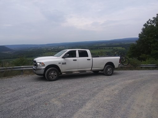
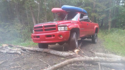
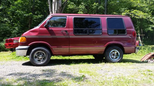
I have also pictured my 3 vehicles. My current vehicle is a 2015 RAM that has done the majority of the scouting and camping (also use our 2015 Cherokee) But I also have a 99 RAM that may be getting the dedicated treatment...and a 99 RAM Van that is on the back burner of a stealth camper project.
20200801_100443.jpg2018-09-15 18.38.18.jpg20160628_113336.jpg


I have expanded my route since learning about all the other state forests...but for this thread I will stick to the original.


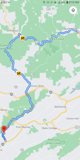
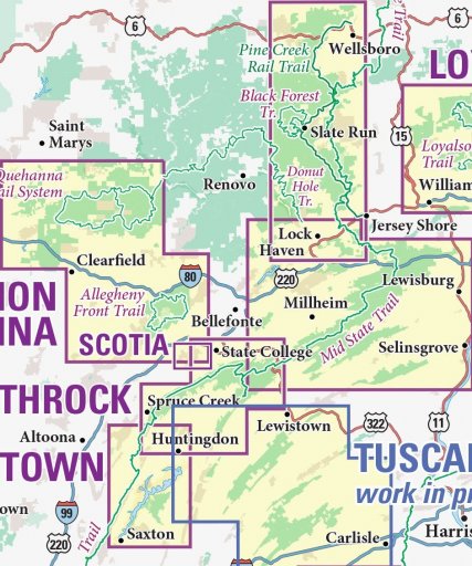
Leaving from home near Altoona I will head to Rothrock. Following forest roads and 4x4 High Clearance trails i will arrive in Bald Eagle. Then, making the best route I can incorporating dirt to the max, I will head to Tiadoghton. These 3 areas will be traveled using the lizard maps. Rothrock, Bald Eagle and Pine Creek. Then the journey will go through Sproul. This is the only area missing the purple lizard and I will be using the sportsman atlas and day use maps for this area. Then into Quehanna and Moshannon. Then a back road drive home.


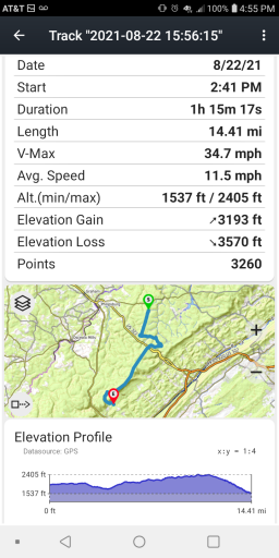
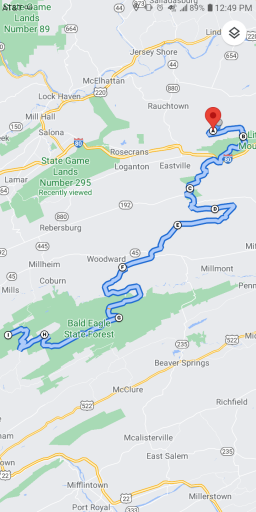
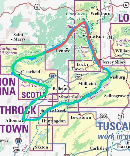
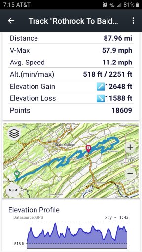
I included a screenshot of my travel from Rothrock to Bald Eagle. Even the most direct route is over 80 miles of dirt. I can easily zig zag through both forests, doubling that number of miles easily.
Screenshot_20200229-191521_US Topo Maps.jpg


So I got the route through Rothrock Bald Eagle and Moshannon scouted. I need to get to areas in the Pine Creek map and it has been a few years since i have been in Sproul.


So any thoughts, recommendations and info would be appreciated. The biggest issue right now is finding time. And deciding how many days I spend at each campsite. 3 works best for me...but that starts to make this a multiple week trip. 2 days may work...but one is not enough.


One of the things that shouldn't be of much concern is fuel and resupply. I have found 10 MPG to be a safe bet for overland travel for my rigs. I have 30 gallons of useable fuel on my rig. So 300 mile range. And being I have no special setup for food storage...i figure I will need to stop for the food more than the fuel. I plan to only use local stores, gas stations and the occasional diner. When I head from the dirt to the needed pavement will be when I make these stops.


The good thing is that this is all a short day trip away for scouting and I can run any section of it any time I get the opportunity. (I have started avoiding the hiways and travel to State College through Rothrock and Bald Eagle now.)


People in the group are always asking where they can go...right here in PA, are some great forests to explore.
 

DevilDodge

Rank IV

Advocate I

1,135
Altoona, Pennsylvania, USA
First Name
David
Last Name
Spencer
I have it all drawn on the maps I have. I will be using my US topo maps app to track me for informational purposes. Like I did in the screen shot.

Not sure if that will make gpx file or not. I only have the free version
 
  • Like
Reactions: Dusther210

DevilDodge

Rank IV

Advocate I

1,135
Altoona, Pennsylvania, USA
First Name
David
Last Name
Spencer
I drive sections of it once or twice a month...the Rothrock section sometimes weekly.

The whole shebang. Might be a year or so. I go to Moshannon quite often too. Getting to Pine Creek or Sproul is the real challenge.

I would appreciate a tag along. But unfortunately...it will not be for awhile. But I will for sure keep this thread posted with any plans and information.
 

DevilDodge

Rank IV

Advocate I

1,135
Altoona, Pennsylvania, USA
First Name
David
Last Name
Spencer
Also. I have already added Tuscarora(waiting on the Lizard map) Loyalsack and Cook's forest to the list of scouting areas. So I will be planning separate trips to these areas.

Buchannon is on my list for camping weekends...but will never be part of the Central PA forest tour lol.

Elk, Susquehannock and Tioga are on the scout list also.

And all these will incorporate a trip when retirement comes.

Most people want to go see new places. I want to see more of the places I know.
 

Dusther210

Rank VI
Member

Influencer I

4,765
Oakland, Bergen County, New Jersey, United States
First Name
Dustin
Last Name
Helms
Member #

24720

Ham/GMRS Callsign
KD2UNH
Also. I have already added Tuscarora(waiting on the Lizard map) Loyalsack and Cook's forest to the list of scouting areas. So I will be planning separate trips to these areas.

Buchannon is on my list for camping weekends...but will never be part of the Central PA forest tour lol.

Elk, Susquehannock and Tioga are on the scout list also.

And all these will incorporate a trip when retirement comes.

Most people want to go see new places. I want to see more of the places I know.
I’m finding each time I go back somewhere it’s different and I never have enough time to see or enjoy everything in one trip… you might be on to something
 

DevilDodge

Rank IV

Advocate I

1,135
Altoona, Pennsylvania, USA
First Name
David
Last Name
Spencer
I did scout a trail that will possibly be the starting or ending point on my journey.

This is the closest dirt to me on a lizard map and takes me right into Moshannon SF.

The gamelands road is packed gravel...but the road to/from it can get pretty rough after some weather.
Screenshot_20210822-165434.pngScreenshot_20210822-165526.png
There is a good bit of dirt connected to here and another 4x4 HC trail.

My son wants to do this section again soon...i let him drive. Pretty good for an 8 year old.
 

DevilDodge

Rank IV

Advocate I

1,135
Altoona, Pennsylvania, USA
First Name
David
Last Name
Spencer
Well Good news. Got the purple lizard maps overlayed into the sportsman atlas.

So I only have to stare at 2 pages in the atlas. And they are on the same fold out.

Pages 94 and 95 (or 106 and 107 if I go lower)

So I officially have the route laid out.

Looks like the intersection of route 872 and 120 is the set point for scouting here.

Maybe next weekend...
 

DevilDodge

Rank IV

Advocate I

1,135
Altoona, Pennsylvania, USA
First Name
David
Last Name
Spencer
Screenshot_20210824-171649.png
The route I will be scouting. Up to position F has been scouted. From F to G is an easy dirt route. From there on it is just a general route. Will add the dirt when I get to location G and enter into the leg i have not scouted.

From A to G is 99% dirt.

Now to make the time to go.
 
  • Like
Reactions: Dusther210

DevilDodge

Rank IV

Advocate I

1,135
Altoona, Pennsylvania, USA
First Name
David
Last Name
Spencer
Got the trip routed for scouting the Gap between the Map.

Not sure of the final plan though. I will be hitting a few new roads on the Moshannon map. I have a tentative route through the Gap...but I haven't decided if I am doing some extra exploring or just making the connection.

Once I get to the Pine Creek Map...i will probably just be taking a direct route to the Bald Eagle Map...so I have time to Get to Rothrock and get a decent track through the area.

If I find some interesting stuff in the GAP or show short on time...i may just skip BESF and Rothrock and explore til dark and take the main roads home.

Guess this is why it is an adventure. You do not always need a plan, just go.
 
  • Like
Reactions: Dusther210

DevilDodge

Rank IV

Advocate I

1,135
Altoona, Pennsylvania, USA
First Name
David
Last Name
Spencer
Decided to go through my State Forest day use map collection.

Sure enough...the Sproul SF Day use map covers this area in great detail.

So now I can adjust my route to better suite dirt.

So...the GAP is now covered with a proper use map.

Still debating the extent of my planned scouting trip. Half of me wants to try to do a quick and to the point route encompassing the whole route just to get a decent track. And the other half wants to explore the GAP.

Decisions.
 

DevilDodge

Rank IV

Advocate I

1,135
Altoona, Pennsylvania, USA
First Name
David
Last Name
Spencer
Interesting fact about the area of the GAP...with the different rivers...there are so many roads that go to the river...but only like 4 bridges.

So...pretry much have to make the trip through these bridges...or much further north.

Which is great for the trip...not so much for scouting.

And with the weather we are getting...some roads are going to be closed.

Looks like I may be leaning toward connecting the dots vs. Exploring the spots.

@Dusther210 thanks for the suggestion. So many ways to do this...input is appreciated.

I got the route plotted on google maps(hoping this selects passable roads) through Moshannon, the GAP and Pine Creek, and I already did from Bald Eagle to Rothrock.

Looking at 7 hours through the north section and should be less than that for the Southern.

So it is plenty doable in one day.

Wife's trip got cancelled...so not sure I can talk her into spending over 12 hours driving on Rocky roads...lol
 

Dusther210

Rank VI
Member

Influencer I

4,765
Oakland, Bergen County, New Jersey, United States
First Name
Dustin
Last Name
Helms
Member #

24720

Ham/GMRS Callsign
KD2UNH
Interesting fact about the area of the GAP...with the different rivers...there are so many roads that go to the river...but only like 4 bridges.

So...pretry much have to make the trip through these bridges...or much further north.

Which is great for the trip...not so much for scouting.

And with the weather we are getting...some roads are going to be closed.

Looks like I may be leaning toward connecting the dots vs. Exploring the spots.

@Dusther210 thanks for the suggestion. So many ways to do this...input is appreciated.

I got the route plotted on google maps(hoping this selects passable roads) through Moshannon, the GAP and Pine Creek, and I already did from Bald Eagle to Rothrock.

Looking at 7 hours through the north section and should be less than that for the Southern.

So it is plenty doable in one day.

Wife's trip got cancelled...so not sure I can talk her into spending over 12 hours driving on Rocky roads...lol
Sounds like you are going to have a great time any way you slice it
 
  • Like
Reactions: DevilDodge

DevilDodge

Rank IV

Advocate I

1,135
Altoona, Pennsylvania, USA
First Name
David
Last Name
Spencer
Using google maps as the time keeper and rounding up...looks like 16 hours to complete the loop.

This is pretty much a direct dirt route through Bald Eagle and Rothrock. Many of the campsites are right on it and a good many 4x4HC trails offshoot in the general direction...so I just would be so tempted to scout too much.

I know the family is not going to be interested in 16 hours bouncing through the forest in one day.

And since I already have done the Rothrock and Bald Eagle stretch many times.

I might be able to convince them to do the Northern Clockwise route through Moshannon, Quehanna, THE GAP, and Pine Creek.

Then another day run the southern Counterclockwise route to where I left off.

Just saw a member here say the sites are booked up...so, camping wasn't in the plan and seems to be out the weekend anyways.

Well, planning stage is done. Scouting is always ongoing.

Now to purgatory waiting for the time.
 

DevilDodge

Rank IV

Advocate I

1,135
Altoona, Pennsylvania, USA
First Name
David
Last Name
Spencer
Got the route done. Figured I would share a section in the most popular BESF.

This route starts on the shared area of the Pine Creek and Bald Eagle Purple Lizard Maps and goes to the motorized site 45 in BESF...setting up the connection to the Roothrock map.


Above is the link to the route and below is a screen shot of the route.Screenshot_20210902-124910.png

It connects all sections of BESF from North to South and takes you to many of the motorized sites.

It also takes you to alot of the 4x4 HC trails. And with a few tweaks you can spend days off pavement.

I got the rest of the route plotted. I have already run the Rothrock section and most of the Moshannon section.

THE GAP area and the Pine Creek route have not been scouted yet.

Let me know if anyone would like a preview of any other section.